 MineArchive
Brodsworth Colliery
| Location | Brodsworth, South Yorkshire — 53.5647, -1.2092 (exact) |
|---|---|
| Commodity | Coal |
| Type | Coal |
| Worked | October 1905 (sinking)–7 September 1990 |
| Maximum depth | Parkgate seam, 742 m |
| Operators | Brodsworth Main Colliery Company (1905–1937), Doncaster Amalgamated Collieries Ltd (1937–1947), National Coal Board (1947–1987), British Coal Corporation (1987–1990) |
Overview
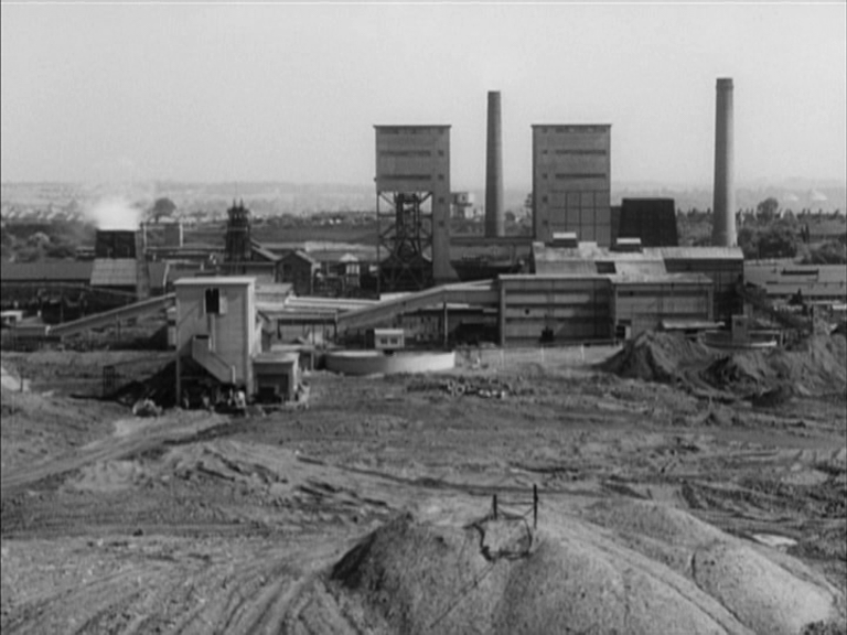
A major South Yorkshire colliery north-west of Doncaster, sunk in 1905-07 as a joint venture between the Hickleton Main Colliery Company and the Staveley Coal and Iron Company. A third shaft added in 1922-23 made it the largest colliery in Yorkshire and, at times, the highest-output three-shaft colliery in Britain. Its associated model village, Woodlands, designed by architect Percy Houfton, is considered one of the finest examples of the early twentieth-century garden-village movement applied to a mining community. The colliery closed in 1990 after 85 years of continuous working.
History
Sinking began on 23 October 1905, with two shafts of 6.25 m diameter sunk as a joint venture between the Hickleton Main Colliery Company and the Staveley Coal and Iron Company, trading as the Brodsworth Main Colliery Company. The Barnsley seam was reached in 1907 at a depth of around 541-595 m (accounts differ slightly) and was up to 9 feet thick; coal-getting from it began in 1908 and continued without a break until 1984. Further seams were worked at greater depths over the colliery's life, including the Dunsil, Parkgate and Thorncliffe seams. A third shaft, sunk in 1922-23, substantially increased capacity, taking the workforce from around 2,500 to 3,500 by 1925 and making Brodsworth the largest colliery in Yorkshire, with the highest recorded output of any three-shaft colliery in Britain. Alongside the colliery, the company built Woodlands, a model village for its workforce, designed by the architect Percy Houfton between 1907 and 1913 on garden-city principles associated with Ebenezer Howard — wide tree-lined avenues, generous open green space and a centrepiece, 'The Park', a 24-acre green ringed by around 120 cottages facing parkland rather than the street. All Saints Church, built for the village by the Thellusson family in 1913, remains its focal point; Woodlands is now a conservation area. Ownership passed to Doncaster Amalgamated Collieries Ltd in 1937 as part of wider industry rationalisation, then to the National Coal Board on nationalisation in 1947. An underground roadway connecting Brodsworth to the neighbouring Bullcroft Colliery was completed in June 1970, and rapid-loading bunkers were installed in 1971 to serve Merry-Go-Round block-train services. Brodsworth remained one of Britain's largest employers of miners into the 1980s, with around 2,800 workers on the books through that decade, before losses in the late 1980s led British Coal to close the colliery on 7 September 1990. Surface plant was demolished the following year.
Geology
Coal of the South Yorkshire field: the Barnsley seam, reached in 1907 at around 541 to 595 metres and up to 9 feet thick, with the Dunsil, Parkgate (about 742 metres) and Thorncliffe seams worked at greater depths later.
Workings
Three shafts ultimately served the colliery. The Barnsley seam was worked from 1908, with the Dunsil, Parkgate (reached at around 742 m) and Thorncliffe seams worked at various periods; BGS abandonment plans record workings in the Surface, Thorncliffe and Parkgate seams, most abandoned on 2 May 1986. An underground connection to Bullcroft Colliery, completed in 1970, allowed the two collieries' workings to be linked.
Closure
Closed by British Coal on 7 September 1990 after sustaining losses in the late 1980s; surface plant was demolished in 1991.
What remains
The colliery site itself has been cleared and its former spoil tip restored as community woodland, with parts of the wider site remediated for housing. The adjoining Woodlands model village survives largely intact as a conservation area.
Related mines
- Bullcroft Colliery — Physically connected underground in 1968 by a 550-yard drift and an 1,800-yard conveyor, after which Bullcroft's coal was raised and washed at Brodsworth rather than at its own shafts. The two merged formally in 1970, and because the last remaining seam could be reached from Brodsworth, the Bullcroft shafts were filled and capped. Both had also been constituents of Doncaster Amalgamated Collieries from 1940.
Nearby mines
- Bullcroft Colliery — 1.5 miles (2.4 km) NE
- Bentley Colliery — 2.8 miles (4.6 km) E
- Frickley Colliery — 3.4 miles (5.5 km) NW
- Barnburgh Main Colliery — 3.6 miles (5.8 km) SW
- Upton Colliery — 4.3 miles (6.9 km) NW, West Yorkshire
Straight-line distance, within 9 miles (15 km). Show on the map.
Culture
- Brodsworth Welfare F.C. (Sports)
The club was founded by the colliery's own sports and pastimes club in 1908 and has carried the pit's name, or its welfare's, ever since.
What's uncertain
Points where sources disagree or the record could not be settled; both accounts are kept. All open questions in the archive.
- The Barnsley seam, up to 9 feet thick, was reached in 1907. Wikipedia gives the depth as 595 yards; the Northern Mine Research Society gives 541 metres — the two figures are close but not identical and are recorded here as separate accounts rather than reconciled. (disputed) 1,2
Recorded claims
Individual factual claims, each attached to the source(s) that support it below. Where sources disagree, both are kept.
- Sinking began 23 October 1905 as a joint venture between the Hickleton Main Colliery Company and the Staveley Coal and Iron Company; ownership passed to Doncaster Amalgamated Collieries Ltd in 1937 and to the National Coal Board on nationalisation in 1947. 1,2
- The Barnsley seam, up to 9 feet thick, was reached in 1907. Wikipedia gives the depth as 595 yards; the Northern Mine Research Society gives 541 metres — the two figures are close but not identical and are recorded here as separate accounts rather than reconciled. (disputed) 1,2
- A third shaft, sunk 1922-23, increased the workforce from around 2,500 to 3,500 by 1925 and made Brodsworth the largest colliery in Yorkshire, with the highest recorded output of any three-shaft colliery in Britain. 1
- An underground connection to the neighbouring Bullcroft Colliery was completed in June 1970, and rapid-loading bunkers for Merry-Go-Round block-train services were installed in 1971. 2
- Brodsworth employed around 2,800 workers through the 1980s before British Coal closed the colliery on 7 September 1990 after it began making losses in the late 1980s; surface plant was demolished in 1991. 1,2
- The BGS/Mining Remediation Authority mine plans catalogue holds abandonment plans for Brodsworth covering the Surface, Thorncliffe and Parkgate seams, most dated 2 May 1986. 3
- The Brodsworth Main Colliery Company built Woodlands, a model village designed by architect Percy Houfton between 1907 and 1913 on garden-city principles, centred on 'The Park' — a 24-acre green surrounded by around 120 workers' cottages. All Saints Church, built by the Thellusson family in 1913, remains its focal point, and the village is now a conservation area. 4
- Located at about 53.565 N, 1.209 W. 1
Sources
- (secondary) Brodsworth Colliery — Wikipedia
- (secondary) Brodsworth Main Colliery — Northern Mine Research Society
- (primary) Mine plan: BRODSWORTH, South Yorkshire (feature 21847489) — Mining Remediation Authority / BGS mine plans catalogue
- (secondary) Woodlands, South Yorkshire — Wikipedia
Record created: 26 August 2026 · Last researched: 26 August 2026