 MineArchive
Brightling and Mountfield Gypsum Mines
| Also known as | Brightling Mine, Mountfield Mine, Sub-Wealden Gypsum Mines, Mountfield Gypsum Mine |
|---|---|
| Location | Brightling and Mountfield, near Battle, East Sussex — 50.9700, 0.3920 (approximate) |
| Commodities | Gypsum, Anhydrite |
| Type | Mineral |
| Worked | from 1876 (Mountfield) |
| Maximum depth | About 300 m at the deepest workings in Brightling Mine |
| Operators | Sub-Wealden Gypsum Company Limited (1876–1903), Gypsum Mines Limited (1903–1936), British Plaster Board Limited (1936–2005), British Gypsum (2005–?) |
Overview
A mining industry founded on a failed experiment: a borehole sunk in the 1870s to test what lay under the Weald found no coal but four seams of gypsum, and the mines that followed are still working today — Brightling so carefully hidden in its wooded valley, and so strictly barred from using the local roads, that its output leaves by one of the longest conveyor belts in Britain.
History
At the 1872 Brighton meeting of the British Association for the Advancement of Science, geologists resolved to sink a borehole as deep as could be managed through the oldest rocks exposed in south-east England — the Purbeck Beds at Limekiln Wood near Mountfield. The subscription that funded it almost certainly carried a commercial hope alongside the scientific question, since coal might conceivably lie beneath. Drilled by the Diamond Rock Boring Company at Counsellors Wood, the hole reached 1,905 ft before the rods broke in 1876 and the work stopped. There was no coal. What the £6,000 had bought instead was the discovery of several thick gypsum seams at between 130 and 160 ft. The Sub-Wealden Gypsum Company Limited was formed on 10 May 1876 under the local chemist William Joel Kemp, and a shaft was sunk about 60 yards from the borehole. Progress was slow in so isolated a spot until a railway link was built to the London to Hastings main line south of Robertsbridge. By the 1880s the mine was raising some 8,000 tons a year; through the 1890s its workforce grew from 15 to 27 underground and from 22 to 60 at surface. In 1903 the business amalgamated with the Kingston Gypsum Company of Nottingham to form Gypsum Mines Limited, both works selling plaster under the name Sirapite — an anagram of Paris, after plaster of Paris. The post-war building booms drove both expansions: 26 kilns and the opening of the no. 4 seam after the First World War, and after the Second a new inclined drift with endless rope haulage and new surface plant. British Plaster Board acquired the business in 1936, and it passed in time to British Gypsum, now part of Saint-Gobain. As Mountfield's reserves ran down, Brightling Mine was opened in 1963 to work the same seams in the neighbouring inlier; Mountfield itself closed in the 1990s, and Brightling has supplied the Robertsbridge works ever since.
Geology
The gypsum lies in the Lulworth Formation of the Late Jurassic Purbeck Limestone Beds, laid down around 140 million years ago in the northern part of the Wealden Basin. The setting was an inter-tidal shelf margin, and the sulphate beds are read as subaerial sabkha deposits — salt flats formed in spells of low humidity and high salinity, alternating with cycles of calcareous mudstone and stromatolite. Four seams are thick enough to be worked and are numbered from the oldest, no. 4, upward. No. 4 is the thickest and is taken at working heights over 3 m; no. 1 is thinner at around 2.5 m but has been worked more extensively because its gypsum content is higher. It is worth being clear about depth here: these evaporites formed at the surface, in the open air, and the 300 m of cover at the deep end of Brightling is the result of later burial and of faulting, not of the conditions the mineral needed to form. The structure was long assumed to be the eroded core of the Wealden Anticlinorium, but several hundred exploration boreholes point instead to a set of east-south-east trending normal faults, mostly throwing southward and occasionally by as much as 100 m, probably reflecting older structures in the Palaeozoic basement that also helped control where the sediments were laid down. It is those elevated fault blocks that carry the best gypsum and put it within reach. The evaporites are nowhere exposed at outcrop, because they simply dissolve where groundwater can reach them.
Geological setting: Evaporite Deposits (well documented example), Faults and Fractures (well documented example)
Workings
Mountfield began as shaft work: an 1881 account describes the no. 1 seam standing 6 to 7 ft high, with headings of about the same width driven by drilling and blasting and a network of underground rails bringing the gypsum to the shaft bottom, where a steam winding engine hoisted it. The Woodland Shaft, some 45 m deep, raised the output. Regular room-and-pillar working came in around 1936. Brightling, opened in 1963, is instead entered by twin drifts driven west at 1 in 6 from a low point near the Dudwell valley to intersect the no. 1 and no. 4 seams, and the workings have since advanced more than 3 km westward along the axis of the anticline to a maximum depth of about 300 m; two large-diameter ventilation shafts were sunk in 1979 to cope with the distance. Extraction is square-set duplex room-and-pillar, rooms 6.5 m wide on 14 m centres with 8 m pillars left standing — an extraction ratio of 68 to 70 per cent, and pillars strong enough that no artificial roof support is needed. A production face runs 15 to 20 headings wide, drilled by two electro-hydraulic rigs, blasted, scaled down, then mucked out by load-haul-dump machine to a crusher and taken out by conveyor. Because some of the shale associated with the gypsum beds is unusually carbon-rich, the mine gives off small quantities of methane, and after a minor gas ignition in the late 1960s it was placed under flame safety lamp status — an unexpected borrowing from coal-mining practice in a plaster mine.
Closure
Mountfield closed as its reserves were effectively worked out, though sources differ on exactly when: the fullest account puts it in the early 1990s, after a heavy media separation plant had for some years allowed anhydrite-contaminated ground to be taken that would otherwise have been left, while trade reporting gives 1998. In its last years Mountfield also sold the Portland Sandstone exposed by working the no. 4 seam as road stone, with a small coating plant on site from the 1960s until 2007. Brightling has not closed. Its output has fallen a long way from a peak approaching a million tonnes a year to around 150,000 tonnes, largely because most plasterboard gypsum now comes from flue-gas desulphurisation at coal-fired power stations rather than out of the ground; what Brightling raises goes mainly as an anhydrite and gypsum blend to the cement industry.
What remains
Brightling remains a working mine and is not accessible — which is also why no exploration account of it exists. Its most striking feature from outside is how little there is to see: the mine sits within the High Weald National Landscape and was deliberately sited to be concealed among the wooded valleys.
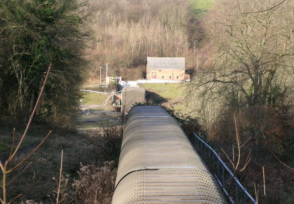
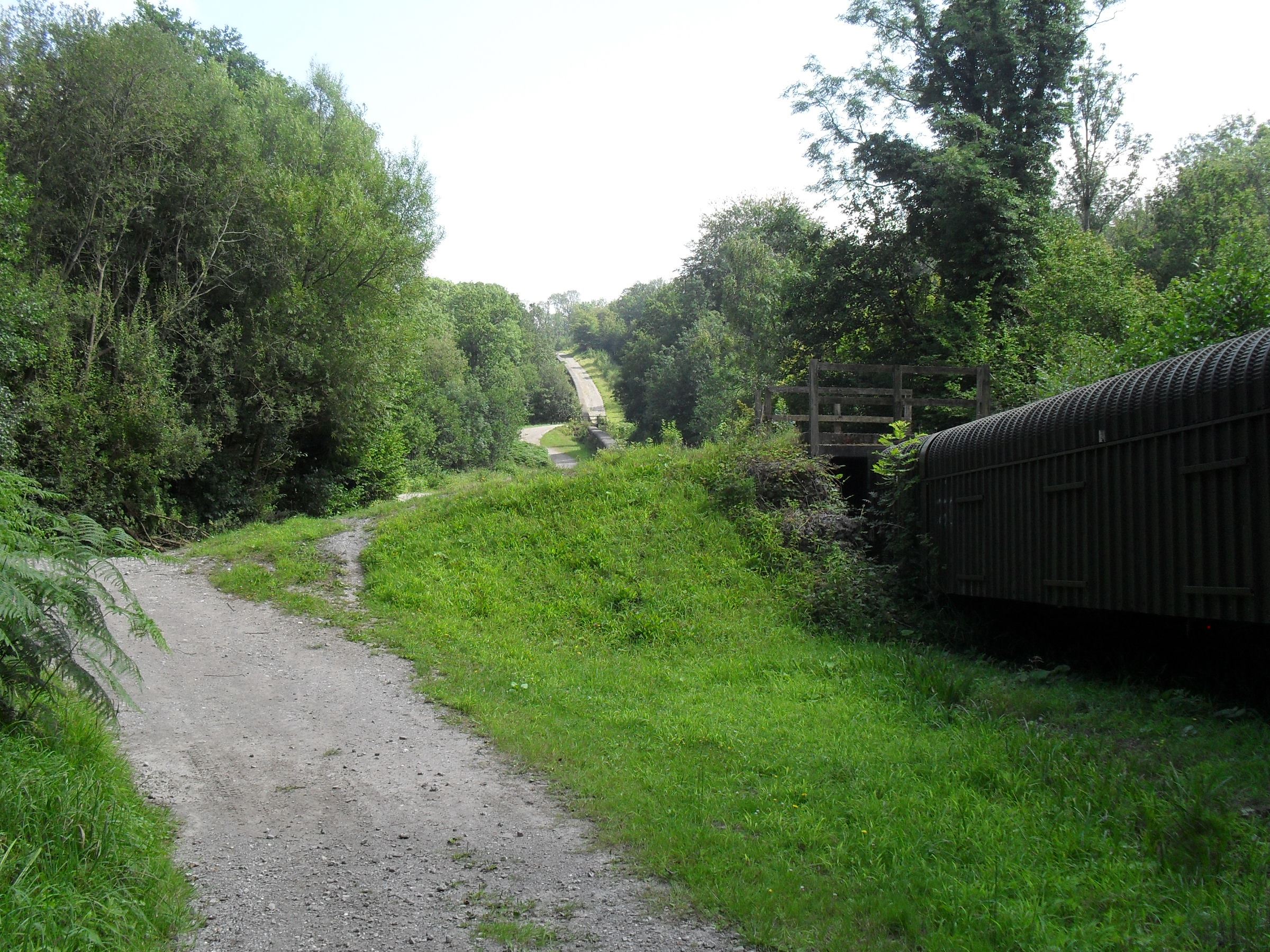
At Brightling, a modest cluster of buildings at the drift mouth and the conveyor running away north-west. Planning conditions forbid moving any material out by road, the local lanes having been built for farm traffic, so the mine's entire output has always travelled overhead: first by a 3.5-mile aerial ropeway to the Mountfield works, routed through woodland and partly hidden in tunnels so it would seldom be seen, and since 1986 by a curved conveyor belt that is among the longest single conveyors in the United Kingdom.
Redevelopment
The Mountfield mine and its Sirapite works have gone, but the site did not go quiet: the Robertsbridge plasterboard works in the valley of the River Line still takes Brightling's output at the end of the conveyor.
Related mines
- Long Meg Mine — Both were worked by British Plaster Board Limited, which bought the Long Meg concern in 1939 and held the Sussex gypsum mines as well — the same company working calcium sulphate at opposite ends of the country, from the Permo-Triassic evaporites of the Eden valley and from the Purbeck beds of the Weald.
Nearby mines
- Ashburnham Furnace — 2.9 miles (4.6 km) S
- Robertsbridge Furnace — 3.4 miles (5.5 km) E
- Beauport Park Roman Iron Mine — 7.9 miles (12.8 km) SE
- Gloucester Furnace, Lamberhurst — 9.0 miles (14.5 km) N, Kent
Straight-line distance, within 9 miles (15 km). Show on the map.
What's uncertain
Points where sources disagree or the record could not be settled; both accounts are kept. All open questions in the archive.
- Brightling is reported as accessed by a 420 m drift at a 1:8 decline, with working depths from about 100 m to 350 m. (uncertain) 2
- Mountfield Mine closed in the early 1990s with its reserves virtually exhausted, having latterly used a heavy media separation plant to work anhydrite-contaminated gypsum. (disputed) 1
- Mountfield Mine is reported to have closed in 1998. (disputed) 2
Recorded claims
Individual factual claims, each attached to the source(s) that support it below. Where sources disagree, both are kept.
- The Sub-Wealden borehole, agreed at the 1872 Brighton meeting of the British Association for the Advancement of Science and drilled at Counsellors Wood by the Diamond Rock Boring Company, reached 1,905 ft before the rods broke in 1876. No coal was found, but several thick gypsum seams were proved at between 130 and 160 ft. 1
- The Sub-Wealden Gypsum Company Limited was formed on 10 May 1876 and sank its first shaft about 60 yards from the borehole. 1
- An 1881 account describes the no. 1 seam worked 6 to 7 ft high by drilling and blasting, with underground rails to the shaft bottom and a steam winding engine; the Woodland Shaft was about 45 m deep. 1
- During the 1880s Mountfield raised about 8,000 tons a year, worth some £9,000 at the mine. 1
- Through the 1890s the workforce rose from 15 to 27 underground and from 22 to 60 at surface. 1
- The company amalgamated with the Kingston Gypsum Company of Nottingham in 1903 to form Gypsum Mines Limited; British Plaster Board acquired the business in 1936, at about which time working changed to regular room-and-pillar. 1
- Both Mountfield and Kingston sold anhydrous plaster under the name Sirapite, an anagram of 'Paris'. 1
- Brightling Mine was opened in 1963 to work the no. 1 seam in the Brightling inlier as Mountfield's reserves ran down, entered by twin drifts driven west at 1 in 6. 1
- Brightling is reported as accessed by a 420 m drift at a 1:8 decline, with working depths from about 100 m to 350 m. (uncertain) 2
- Extraction is square-set duplex room-and-pillar: rooms 6.5 m wide on 14 m centres with 8 m pillars, an extraction ratio of 68 to 70 per cent, and no artificial roof support required. 1
- The workings have advanced over 3 km west along the axis of the anticline to a maximum depth of about 300 m; two large-diameter ventilation shafts were sunk in 1979. 1
- Carbon-rich shale associated with the gypsum beds releases small amounts of methane, and the mine was given flame safety lamp status after a small gas ignition in the late 1960s. 1
- Planning conditions prohibit exporting material from Brightling by road. Output went first by a 3.5-mile aerial ropeway to Mountfield, partly hidden in tunnels, replaced in 1986 by a curved conveyor that is among the longest single conveyors in the UK. 1
- The evaporites lie in the Lulworth Formation of the Purbeck Limestone Beds (about 140 Ma) and are interpreted as subaerial sabkha deposits; they are nowhere exposed at surface because they dissolve in groundwater. 1
- Several hundred exploration boreholes indicate the dominant structures are east-south-east trending normal faults with southward throws of up to about 100 m, rather than the Wealden Anticlinorium folding long assumed; these elevated fault blocks carry the workable gypsum. 1
- Mountfield Mine closed in the early 1990s with its reserves virtually exhausted, having latterly used a heavy media separation plant to work anhydrite-contaminated gypsum. (disputed) 1
- Mountfield Mine is reported to have closed in 1998. (disputed) 2
- Brightling's output once approached 1 million tonnes a year but had fallen to about 150,000 tonnes, all from the no. 4 seam, supplied mainly as an anhydrite and gypsum blend to the cement industry. 1
Photographs & further reading
Archive photographs of the mines, the Sirapite kilns and the works, set out as a slideshow.
View sourceFootage of the modern working mine — about as close to an underground look as this site allows, since it has never been open to explorers.
View sourceSources
- (primary) A Visitor's Guide to Brightling Mine (C. R. Thomas; geology by Noel Worley, 2010) — East Sussex County Council planning register
- (secondary) British Gypsum: Brightling gypsum mine — Global Gypsum Magazine
- (primary) Mine plans KP3804, KP3885, KP3906-KP3910: Brightling Mine, No. 1, No. 2 and No. 4 seams — British Geological Survey / Mining Remediation Authority mine plans catalogue
- (primary) Mine plans KP3911-KP3914 and OM17906: Mountfield Mine, No. 1, No. 3 and No. 4 seams — British Geological Survey / Mining Remediation Authority mine plans catalogue
- (primary) Mountfield Gypsum Mines (archive collection AMS7292) — The Keep, East Sussex Record Office
- (secondary) Brightling Mine, Rother, East Sussex — Mindat
Record created: 24 August 2026 · Last researched: 24 August 2026