 MineArchive
Braysdown Colliery
| Location | Braysdown, Peasedown St John, near Radstock, Somerset — 51.3109, -2.4253 (approximate) |
|---|---|
| Commodity | Coal |
| Type | Coal |
| Worked | 1845–29 October 1959 |
| Maximum depth | 1,834 ft (559 m); the shaft was 10 ft in diameter |
| Operators | Daubeny and Scobell (?–1900), Braysdown Colliery Company (1908–1947), National Coal Board (1947–1959) |
Overview
Braysdown was sunk in 1845 on the Somerset coalfield south of Bath, and the village of Peasedown St John grew up around it. Its single shaft, ten feet in diameter, eventually reached 1,834 feet — deep for a coalfield whose seams were thin, steeply disturbed and expensive to work at any depth. It was owned by Daubeny and Scobell in the later nineteenth century and by the Braysdown Colliery Company from the early twentieth, was joined underground to Camerton New Pit in 1928, and was still producing 37,250 tons at nationalisation. It closed in 1959, one of the last group of Somerset pits to go.
History
Before 1845 there was no village here to speak of. The scattering of buildings at the top of the hill was known as The Red Post, after the public house, and in 1841 there was still nothing that could be called a settlement beyond a few cottages and some building along what became the Bath Road. The sinking of Braysdown that year meant accommodation had to be built for the workforce, and the expansion of Peasedown became inevitable; by the second half of the twentieth century there were at least six collieries within a mile and a half of the village.
The official 1880 list of collieries at work returns the pit simply as "Braysdown, Radstock, Daubeny and Scobell", and the same owners appear in 1896. By 1908 it was in the hands of the Braysdown Colliery Company, which Grace’s Guide’s transcription of the 1922 list of colliery undertakings still records at Braysdown Colliery, Peasedown St John. In 1928 the workings were joined underground to the New Pit at Camerton, two miles north-west. At nationalisation in 1947 Braysdown was producing 37,250 tons a year. New pithead baths opened in August 1956, and coal winding at Braysdown ceased almost immediately afterwards; the colliery closed completely on 29 October 1959.
Geology
The Somerset coalfield produced coal of a very good grade, but in thin seams that were folded and faulted by the Variscan earth movements and correspondingly difficult and expensive to work. That combination governs the whole field: shafts had to go deep for comparatively little coal, and Braysdown’s 1,834 feet — over 550 metres for a pit raising a few tens of thousands of tons a year by the 1940s — is a fair illustration of it. The coalfield had thirty pits at the start of the twentieth century, fourteen by the mid-1930s, twelve at nationalisation, five by 1959 and none after 1973.
Geological setting: Sedimentary Beds and Seams (well documented example)
Workings
A single shaft ten feet in diameter, deepened over the colliery’s life to a maximum of 1,834 feet. From 1928 the workings connected underground with Camerton New Pit. In the colliery’s last years coal traffic from Braysdown, Writhlington and Lower Writhlington ran out over the Somerset and Dorset line through Radstock; after that railway’s closure was decided in 1966 a connection was retained to keep the coal moving to Portishead power station.
Closure
Braysdown was among the five pits still working in the Somerset coalfield in 1959, at the end of a long contraction from thirty at the start of the century. New pithead baths had been opened in August 1956 and coal winding stopped almost at once; the colliery closed completely on 29 October 1959. Mining in the coalfield as a whole ended in 1973.
What remains
The colliery is gone and the ground reclaimed. Its spoil heap — a batch, in the Somerset word — was planted with conifers and is now known as Braysdown Hill. Peasedown St John, the village the pit created, has long since become a commuter settlement for Bath and Bristol.
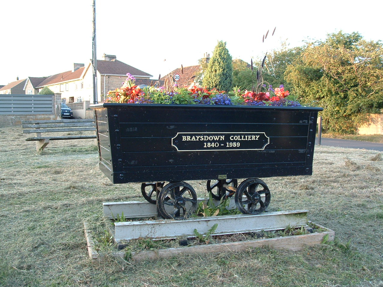
Braysdown Hill, the planted colliery batch, and Braysdown Lane, which still carries the name. A mine tub has been set up in Peasedown St John as a memorial to the colliery and planted as a flower bed.
Related mines
- Camerton Colliery — Joined underground in 1928: a roadway driven through from Braysdown replaced the disused Camerton Old Pit shaft as the New Pit’s second means of escape and airway.
Nearby mines
- Camerton Colliery — 1.2 miles (1.9 km) NW
- Tyning Colliery — 1.3 miles (2.1 km) S
- Clandown Colliery — 1.5 miles (2.4 km) W
- Old Pit Radstock — 1.6 miles (2.5 km) SW
- Dunkerton Colliery — 1.7 miles (2.8 km) NE
Straight-line distance, within 9 miles (15 km). Show on the map.
What's uncertain
Points where sources disagree or the record could not be settled; both accounts are kept. All open questions in the archive.
- The BGS mine-plans catalogue holds a Mining Remediation Authority abandonment plan titled 'Braysdown' (catalogue SWR258, Top Little Vein & Radstock Group, dated 1910); the catalogue gives no location and the plan's details do not clearly tie it to this working, so it may belong to another of the same name. (uncertain) 4
Recorded claims
Individual factual claims, each attached to the source(s) that support it below. Where sources disagree, both are kept.
- Braysdown was sunk in 1845, and the accommodation built for its workforce turned Peasedown St John from a scatter of cottages round the Red Post into a village. 1,2
- The shaft was 10 ft in diameter and reached a maximum depth of 1,834 ft (559 m). 1
- The colliery was owned by Daubeny and Scobell in 1896 — the same partners returned in the official 1880 list of collieries at work — and by the Braysdown Colliery Company by 1908, which Grace’s Guide still records there in 1922. 3,1
- In 1928 Braysdown was joined underground to Camerton New Pit. 1
- At nationalisation in 1947 Braysdown was producing 37,250 tons; it closed in 1959, by which time only five pits were left in the Somerset coalfield. 1
- The Braysdown spoil heap was planted with conifers and is now known as Braysdown Hill. 1
- The BGS mine-plans catalogue holds a Mining Remediation Authority abandonment plan titled 'Braysdown' (catalogue SWR258, Top Little Vein & Radstock Group, dated 1910); the catalogue gives no location and the plan's details do not clearly tie it to this working, so it may belong to another of the same name. (uncertain) 4
Photographs & further reading
The fullest available summary of the field Braysdown belonged to, with a pit-by-pit table of the Writhlington group — opening and closing dates, shaft diameters and maximum depths — compiled from Down and Warrington’s history of the coalfield.
View sourceThe parish council’s own account of how the village came into being: no settlement to speak of in 1841, the sinking of Braysdown in 1845, and six collieries within three kilometres by the mid-twentieth century.
View sourceSources
- (secondary) Somerset Coalfield — Wikipedia
- (secondary) Village History — Peasedown St John — Peasedown St John Parish Council
- (primary) 1922 Colliery Undertakings — Grace’s Guide to British Industrial History
- (primary) BGS / Mining Remediation Authority mine plans: BRAYSDOWN — British Geological Survey / Mining Remediation Authority
Record created: 6 September 2026 · Last researched: 6 September 2026