 MineArchive
Beldi Hill Mine
| Location | Muker, Swaledale, North Yorkshire — 54.4021, -2.1517 (exact) |
|---|---|
| Commodity | Lead |
| Type | Metal |
| Worked | early 1700s–1883 |
| Maximum depth | Unknown. Worked through numerous levels driven from several directions by competing groups of adventurers. |
| Operators | Thomas Smith (1738–?), Thompson & Company |
Overview
An ancient lead mine at the western end of Swaledale, most active from the early 1700s to the late 1800s, whose ownership was contested in a legal dispute so bitter it was only resolved by the House of Lords.
History
Lead had been worked on a small scale at Beldi Hill for centuries before sustained mining began in earnest in the early 1700s, continuing into the late 19th century. The mine is a genuinely complex site, with different groups of 'adventurers' driving levels from several directions to reach ore veins running roughly east-west through the hill, served by three separate mills -- two for ore-dressing and one for smelting. Ownership of the lead itself became bitterly contested after 1738, when the Trustees of the Duke of Wharton sold the manors of Healaugh and Muker to Thomas Smith in an agreement that left lead rights under unenclosed land ambiguous; Lord Pomfret, who held mineral rights elsewhere on the same land, disputed Smith's claim. The argument ran for over three decades before being settled in Smith's favour in the early 1770s, but only after Pomfret carried his appeal all the way to the House of Lords, with trials running from 1769 to 1772. Vindicated, Smith abandoned his earlier smelt mills at Barney Beck and Spout Gill and built a new one at Beldi Hill in Swinner Gill in 1771, initially with a single ore hearth; later lessees, Thompson & Company, added a second hearth and a roasting furnace to increase output. Duty records from 1854-62 document the mine's lead output through its later working life. By 1882 the mill was described in the Mining Journal as a shadow of its former self, and it smelted its last batch of ore the following year, in 1883.
Geology
Lead veins running roughly east-west through the hill above Swinner Gill, reached by levels driven from several directions by competing groups of adventurers.
Workings
Numerous levels driven from several directions by competing groups of adventurers to reach lead veins running roughly east-west through the hill; ore was processed at two dressing mills and smelted at a third, dedicated smelt mill.
Closure
The smelt mill, by then already in decline, smelted its final batch of ore in 1883.
What remains
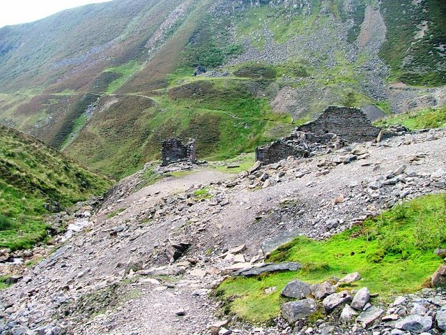
The ruins of the smelt mill survive in Swinner Gill, set into the hillside below a waterfall.
The ruined Beldi Hill smelt mill in Swinner Gill, along with associated mining remains across the hill.
Related mines
- Swinnergill Mine — Both mines were shaped by the same Smith-Pomfret mineral rights dispute; Swinnergill's owners were the losing side, while the ruling produced Beldi Hill's own smelt mill.
Nearby mines
- Swinnergill Mine — 0.6 miles (0.9 km) NE
- Arn Gill Mine — 2.1 miles (3.3 km) SE
- West Stonesdale Mine — 2.1 miles (3.3 km) NW
- Crackpot Moor Mine — 2.1 miles (3.4 km) S
- Sun Hush Mine — 2.2 miles (3.5 km) E
Straight-line distance, within 9 miles (15 km). Show on the map.
Recorded claims
Individual factual claims, each attached to the source(s) that support it below. Where sources disagree, both are kept.
- A dispute over lead rights under Beldi Hill's unenclosed land, arising from an ambiguous 1738 sale of the manors of Healaugh and Muker to Thomas Smith, ran for over three decades between Smith and Lord Pomfret before being settled in Smith's favour in the early 1770s, only after an appeal to the House of Lords with trials running 1769-1772. 1
- Thomas Smith built the Beldi Hill smelt mill in Swinner Gill in 1771 with a single ore hearth; later lessees Thompson & Company added a second hearth and a roasting furnace, and the mill smelted its final batch of ore in 1883. 1
- The mine was worked by different groups of adventurers driving levels from several directions to reach lead veins running roughly east-west through the hill, served by three mills -- two for ore-dressing and one for smelting. 2
Photographs & further reading
A walking-route guide describing the surviving mine and mill remains at Beldi Hill.
View sourceSources
- (secondary) Beldi Hill Smelt Mill — Out & About
- (secondary) Beldi Hill Lead Mine Walk — Yorkshire Dales National Park
- (observational) Swinner Gill Lead Mine Buildings — Geograph Britain and Ireland (Mick Garratt)

Record created: 30 August 2026 · Last researched: 30 August 2026