 MineArchive
Crackpot Moor Mine
| Location | Crackpot, near Keld, North Yorkshire — 54.3730, -2.1670 (approximate) |
|---|---|
| Commodity | Lead |
| Type | Metal |
| Worked | Worked from the early 18th century–Late 19th century |
| Maximum depth | Unknown. |
Overview
A lead mine on Crackpot Moor above Swaledale, worked from the early 18th century to the late 19th, whose mining company used the nearby Crackpot Hall as its office until subsidence from the mine's own workings eventually made the building uninhabitable.
History
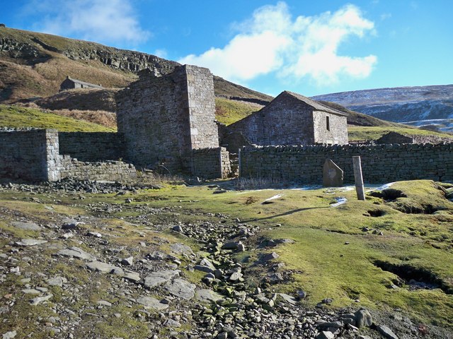
Crackpot Moor Mine was worked from the early 18th century, when Swaledale -- previously a mainly agricultural dale -- was transformed into a hive of industry as lead mining attracted thousands of workers hoping to make their fortune from the galena veins running through the local limestone. The mine's company used Crackpot Hall, a farmhouse built on the site of an earlier royal-forest hunting lodge, as its office right up until the late 19th century. A water-powered crushing mill and ore bins survive at the mine site, and bottles and sticks of dynamite left behind by the miners have been found nearby. Crackpot Hall itself later reverted to agricultural use once mining ceased, but subsidence caused by the mine's own underground workings eventually undermined the building, rendering it uninhabitable by the 1950s; it has stood derelict ever since, and is now cared for by the Gunnerside estate in partnership with the Yorkshire Dales Millennium Trust.
Geology
Galena veins in the limestone of Swaledale.
Workings
Worked from galena veins in the local limestone; ore was processed at a water-powered crushing mill, with surviving ore bins on site.
Closure
Worked until the late 19th century.
What remains
A water-powered crushing mill and ore bins survive at the mine site; the associated Crackpot Hall stands derelict nearby, undermined by subsidence from the mine's own workings, and is now cared for by the Gunnerside estate in partnership with the Yorkshire Dales Millennium Trust.
A water-powered crushing mill and ore bins; the derelict Crackpot Hall nearby.
Nearby mines
- Lover Gill Mine — 1.2 miles (1.9 km) SW
- Stockdale Colliery — 1.7 miles (2.8 km) W
- Arn Gill Mine — 2.1 miles (3.3 km) E
- Beldi Hill Mine — 2.1 miles (3.4 km) N
- Swinnergill Mine — 2.6 miles (4.2 km) NE
Straight-line distance, within 9 miles (15 km). Show on the map.
Recorded claims
Individual factual claims, each attached to the source(s) that support it below. Where sources disagree, both are kept.
- The mine's company used Crackpot Hall, a farmhouse built on the site of an earlier royal-forest hunting lodge, as its office right up until the late 19th century. 1
- A water-powered crushing mill and ore bins survive at the mine site; Crackpot Hall itself, after reverting to agricultural use, was later undermined by subsidence from the mine's own workings, rendering it uninhabitable by the 1950s. 1
- Swaledale, previously a mainly agricultural dale, was transformed into a hive of industry from the early 18th century as lead mining attracted thousands of workers hoping to make their fortune. 2
Photographs & further reading
The wider Swaledale lead-mining context within which Crackpot Moor Mine and Crackpot Hall sit.
View sourceSources
- (secondary) The mysteries of Crackpot Hall - the stories behind the name — Real Yorkshire
- (secondary) Lead Mining in Swaledale — Yorkshire Dales National Park
Record created: 30 August 2026 · Last researched: 31 August 2026