 MineArchive
Swinnergill Mine
| Location | Swinner Gill, Swaledale, near Keld, North Yorkshire — 54.4071, -2.1402 (approximate) |
|---|---|
| Commodity | Lead |
| Type | Metal |
| Worked | Late 1740s–Mid-1830s |
| Maximum depth | Unknown. |
| Operators | Thomas Hopper & Co. (1807–1819), London Lead Company |
Overview
A lead mine established in Swinner Gill, upper Swaledale, in the late 1740s and worked until the mid-1830s, whose owners -- the losing side of the same Smith-Pomfret mineral rights dispute that shaped the neighbouring Beldi Hill Mine -- built their own smelt mill beside a waterfall on the beck.
History
Swinnergill Mine was established in the late 1740s where East Grain Beck drops by a waterfall into Swinner Gill, a tributary valley of Swaledale near Keld, extracting galena (lead ore) by shaft and later by an adit, Parkes Level, driven from lower in the valley in the mid-1740s. The mine had earlier belonged to the London Lead Company before passing to Lord Pomfret and Peter Denys, whose grouping of workings became known as the 'A.D. Mines' -- the same Lord Pomfret who spent over three decades disputing Thomas Smith's mineral rights over Healaugh and Muker manor, immediately across the valley, in the fight that eventually produced the neighbouring Beldi Hill Mine's own smelt mill after the House of Lords found against Pomfret in the early 1770s. Thomas Hopper & Co. leased Swinnergill and built its smelt mill, which was operational by 1807 but is recorded as already disused on an 1850s map; a lead-duty record survives showing no returns for duty lead -- the tax paid on lead production -- after 1819, suggesting the mine's main working life had ended by then even though sporadic activity is recorded into the mid-1830s. By 1832, cumulative production from the mine had reached over 1,964 tons of ore. Later prospectors made unsuccessful attempts to reopen workings in the 1860s and 1870s, but the mine never returned to significant production.
Geology
Lead of the Swaledale orefield, worked where East Grain Beck drops by a waterfall into Swinner Gill.
Workings
Lead ore worked originally by shaft and later via Parkes Level, an adit driven in the mid-1740s from lower in the valley; ore was smelted at the mine's own mill beside the Swinner Gill waterfall, operational by 1807.
Closure
No lead-duty returns survive after 1819, suggesting the mine's substantial working life had ended by then, though some activity continued into the mid-1830s; later 1860s-70s reopening attempts failed.
What remains
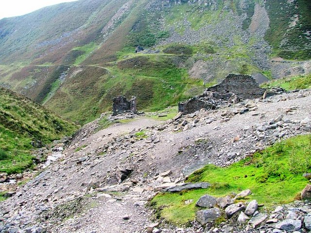
Ruinous mine buildings and spoil heaps survive beside the smelt mill ruins at the Swinner Gill waterfall.
Ruined smelt mill, mine buildings and spoil heaps beside the waterfall where East Grain Beck drops into Swinner Gill.
Related mines
- Beldi Hill Mine — Both mines were shaped by the same Smith-Pomfret mineral rights dispute; Swinnergill's owners were the losing side, while the ruling produced Beldi Hill's own smelt mill.
Nearby mines
- Beldi Hill Mine — 0.6 miles (0.9 km) SW
- Sun Hush Mine — 1.7 miles (2.7 km) E
- West Stonesdale Mine — 2.1 miles (3.3 km) NW
- Arn Gill Mine — 2.1 miles (3.4 km) SE
- William Gill Colliery — 2.5 miles (4.0 km) N
Straight-line distance, within 9 miles (15 km). Show on the map.
Recorded claims
Individual factual claims, each attached to the source(s) that support it below. Where sources disagree, both are kept.
- Swinnergill passed from the London Lead Company to Lord Pomfret and Peter Denys, whose grouping of workings became known as the 'A.D. Mines'; Pomfret was the losing party in a mineral-rights dispute with Thomas Smith over the neighbouring manors of Healaugh and Muker, settled against him by the House of Lords in the early 1770s. 1
- By 1832 the mine had produced over 1,964 tons of ore; no returns survive for duty lead (the tax paid on lead production) after 1819, though the mine remained active on some scale until the mid-1830s, and later 1860s-70s attempts to reopen it failed. 1
- By 1832 over 1,964 tons of ore had been raised; production ceased in the mid-1830s, with attempts at mining again in the 1860s and 1870s. 1
- The Mining Remediation Authority's abandonment plan OM2040, two sheets at two chains to the inch, covers Swinnergill with Beldi Hill, Coates, Crackpot Hall, Crow Beds, Hutchinson's, Landy Low, Milners, New Raws, White and Wallace. 2
- SWAAG's photographic record of June 2010 places the Swinnergill mines at NY 910 013, 466 metres up. 3
Sources
- (secondary) Swinner Gill Lead Mine In Richmond — Fabulous North
- (primary) Beldi Hill, Swinnergill and other mines: abandonment plan OM2040 (BGS mine plans catalogue) — British Geological Survey / Mining Remediation Authority
- (secondary) SWAAG database: mining-related records (Mining 1) — Swaledale and Arkengarthdale Archaeology Group (SWAAG)
- (observational) Swinner Gill Lead Mine Buildings — Geograph Britain and Ireland (Mick Garratt)

Record created: 30 August 2026 · Last researched: 24 September 2026