 MineArchive
Askern Main Colliery
| Location | Askern, South Yorkshire — 53.6250, -1.1500 (approximate) |
|---|---|
| Commodity | Coal |
| Type | Coal |
| Worked | April 1911–20 December 1991 |
| Maximum depth | 656.5 metres (Flockton seam) |
| Operators | Askern Coal & Iron Co. Ltd (1911–1947), National Coal Board (1947–?) |
Overview
A Doncaster-area colliery sunk from 1911 with the largest winding engines installed anywhere in Britain, whose adjacent Coalite smokeless-fuel plant closed five years before the colliery itself.
History
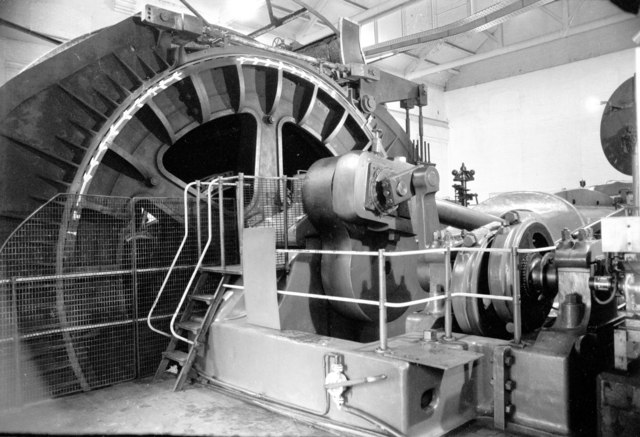
Askern Main Colliery was sunk by the Askern Coal & Iron Co. Ltd, work beginning in April 1911 on two 6.55-metre-diameter shafts, which were taken through waterlogged ground using tubbing. The Barnsley seam horizon was reached at 515 metres, though here the seam was diminished, worked as a combination of the Top Softs and Rider coal known locally as the Warren House seam; the shafts were later extended to the Flockton seam at 656.5 metres, worked from 1913 to 1928 and again by the NCB from 1951 to 1969, but the Warren House seam supplied most of the colliery's coal throughout. Mining was further complicated by the proximity of the Morley Campsall Fault Belt. Two winding engines installed in 1912, built by Yates and Thom Ltd of Blackburn, were the largest of their kind installed anywhere in Britain; identical to the engine at Astley Green in Lancashire, they were demolished around 1981, while Astley Green's survives. The colliery was connected to the London Midland & Scottish Railway's Askern Branch, and from the late 1920s a Coalite smokeless-fuel plant was built next door, taking part of Askern's output; the Coalite plant continued operating until 1986, five years before the colliery itself closed. Ownership passed to the National Coal Board at nationalisation in 1947 and to British Coal Corporation from 1987. Employment peaked at around 2,650 in the 1930s, and in 1967 1,750 men were producing 700,000 tons a year. Falling coal prices led to serious financial losses in Askern's final years, and the colliery closed on 20 December 1991.
Geology
The colliery stood on the Permian limestone ridge above Askern, over the concealed Yorkshire coalfield. At 515 metres the Barnsley seam was much thinned, and only its top part, where the Top Softs and Rider coals combine as the Warren House seam, was worked; the Flockton seam at 656.5 metres carried 0.9 metres of bright coal, and the Morley Campsall Fault Belt nearby disrupted working.
Geological setting: Sedimentary Beds and Seams (well documented example)
Workings
Two shafts sunk from 1911, reaching the Warren House seam (a combination of Top Softs and Rider coal) at 515 metres and later extended to the Flockton seam at 656.5 metres; the High Hazel (Kent's Thick) seam was also worked between 1933 and 1937. The Flockton seam, 0.9 metres of bright coal, was worked in 1913-28 and 1951-69; ventilation was by a Walker fan 6.4 metres across.
Closure
Closed 20 December 1991; falling coal prices had led to serious financial losses in the colliery's final years.
What remains
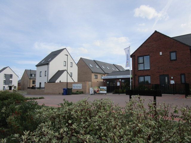
The colliery has gone: by 2018 new housing, The Springs, had been built on its site, and tracks crossed the ground of its former spoil heaps.
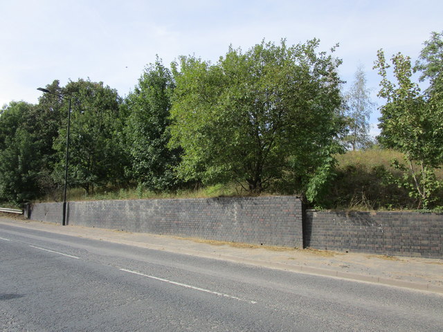
A former railway bridge abutment on Campsall Road, which carried the tracks linking parts of the colliery, survived in 2018.
Nearby mines
- Bullcroft Colliery — 3.3 miles (5.4 km) SW
- Bentley Colliery — 4.1 miles (6.6 km) S
- Brodsworth Colliery — 4.8 miles (7.8 km) SW
- Upton Colliery — 5.1 miles (8.2 km) W, West Yorkshire
- Frickley Colliery — 5.4 miles (8.7 km) W
Straight-line distance, within 9 miles (15 km). Show on the map.
Recorded claims
Individual factual claims, each attached to the source(s) that support it below. Where sources disagree, both are kept.
- Sinking of two 6.55-metre-diameter shafts began in April 1911, reaching the Barnsley seam horizon (worked as the Warren House seam) at 515 metres. 1
- Two winding engines installed in 1912, built by Yates and Thom Ltd of Blackburn, were the largest of their kind installed anywhere in Britain. 1
- The colliery closed on 20 December 1991 after low coal prices caused serious financial losses. 1,2
- The Durham Mining Museum's own summary explicitly states no disaster of five or more deaths is recorded for this colliery. 2
- A Coalite smokeless-fuel plant, built next to the colliery from the late 1920s and taking part of its output, closed in 1986, five years before the colliery itself closed in 1991. 1,3
- The shafts were sunk through waterlogged ground using tubbing; ventilation was by a Walker fan 6.4 metres in diameter. 1
- The 1912 Yates and Thom winding engines, identical to the one at Astley Green in Lancashire, were demolished around 1981 while Astley Green's survives; a photographer who recorded them in 1980 says the pair were scrapped in 1981 and 1982. 1,4,5
- The Flockton seam was worked from 1913 to 1928 and again by the NCB from 1951 to 1969, and the High Hazel from 1933 to 1937, but most of the coal throughout the mine's life came from the Warren House seam. 1
- Output was 409,000 tons in 1947; in 1967 1,750 men produced 700,000 tons a year from the Warren House seam at 566 yards. 2
- By 2018 new housing, The Springs, stood on the site of the colliery, and a former railway bridge abutment on Campsall Road marked the line that linked its parts. 6,7
Photographs & further reading
A history of the shafts, seams, record-sized winding engines and the neighbouring Coalite plant, to closure in 1991.
View sourceOwners, output and employment by year, and the names of men known to have died at the colliery.
View sourceSources
- (secondary) Askern Main Colliery — Northern Mine Research Society
- (primary) Durham Mining Museum - Askern Main Colliery — Durham Mining Museum
- (secondary) Coalite — oldminer.co.uk
- (observational) Askern Colliery - winding engine (Geograph photo 4204176, Chris Allen, 1980) — Geograph Britain and Ireland
- (observational) Enormous winding engine, Askern Main Colliery (Geograph photo 1751867, Chris Allen, 1980) — Geograph Britain and Ireland
- (observational) The Springs, Askern (Geograph photo 5889275, Jonathan Thacker, 2018) — Geograph Britain and Ireland
- (observational) Former bridge abutment, Campsall Road (Geograph photo 5895181, Jonathan Thacker, 2018) — Geograph Britain and Ireland
- (primary) Askern Main 1 & 2 (BGS mine plans catalogue, item 21904814) — British Geological Survey
Record created: 27 August 2026 · Last researched: 18 September 2026