 MineArchive
Wye Valley Mine
| Also known as | West Wye Valley Mine, Nantygwrdy Mine, Dolminers Mine, West Nanty Mine, New Wye Valley Mine |
|---|---|
| Location | Upper Wye valley, about a mile south of Nantiago, Llangurig, Powys — 52.4513, -3.7282 (exact) |
| Commodities | Lead, Zinc |
| Type | Metal |
| Worked | 1863–1884 |
| Maximum depth | About 80 fathoms (Dolminers, about 146 m) |
| Operators | John Taylor & Sons (1863–1867, manager) — Managing the eastern mine in July 1863: engine shaft, adit cross-cut and a 30-foot wheel. The mine was for sale in 1867. Wye Lead Mining Company (1868–1872) — Began the western mine: Murchison's shaft and a 40-foot waterwheel. Wye Valley Company (1874–1879) — Reworked the eastern mine, installed self-acting dressing machinery and sank a new shaft; dissolved in 1879. West Wye Valley Lead Mining Company (1875–1880) — Reworked the western mine, sank Brooke's shaft and built the cottages. |
The Wye Valley mines were two lead mines facing each other across the upper Wye, a mile south of Nantiago and twelve miles by road from Llanidloes. The eastern mine, also called Nantygwrdy or West Nanty, was opened in 1863 under John Taylor and Sons and revived in 1874; the western, Dolminers or West Wye Valley, began in 1868. Both failed in depth. The eastern mine returned 1,904 tons of lead ore and the western 360.
Location
Recorded location. The large pin is this mine; the small round markers are the nearest mines on record. Click one for its page. View on full map
History
In 1846 the lode in the Nantygwrdy ravine was admired by visiting mining men and, it seems, barely touched. Work began in earnest in July 1863, when John Taylor and Sons were sinking an engine shaft, driving an adit cross-cut and preparing for a 30-foot waterwheel. By 1866 ore was coming from five stopes above the adit, though the 10-fathom level found the lode badly disordered by a cross-course. In 1867, at a 34-fathom level, the mine was put up for sale together with Nanty.
A revival came in 1874. After a false start under the name North Van Mines, the Wye Valley Company was formed with Ross and Kitto among its managers, on an assurance that the mine was on the Van lode. The Taylors had missed some good ore: almost at once the adit was giving 30 tons a month and the company paying dividends of ten per cent. Self-acting dressing machinery was put in and a new shaft sunk to the east. A winze below the 10 struck a splendid run of ore in 1876, and after that it went downhill. The company was dissolved in 1879. Kitto and his son carried on, sinking the new shaft to a 46-fathom level in a lode that looked masterly and held next to nothing, until the mine faded away in the mid 1880s.
Across the river the Wye Lead Mining Company, a promotion of John Henry Murchison, started in 1868. Murchison's shaft was sunk under Captain John Paull, and a 40-foot wheel fed by a mile-long leat from the Cyff brook began pumping and winding in 1869. A 40-fathom level reached in 1872 showed very little ore, an attempt to refloat the mine as New Van found no backers, and work stopped. Kitto and Co., encouraged by their luck on the other bank, formed the West Wye Valley Lead Mining Company in 1875, sank Brooke's shaft, laid out dressing floors, put up a new wheel that also drove a sawmill, and built four cottages meant to sleep 32 men beside the tenants. The lode failed in depth here too. Mining ended in 1880.
Geology
The eastern mine is on a branch lode that dips south at about 85 degrees and shows in the Nantygwrdy ravine as a mass of breccia and brown sugary quartz 12 to 15 feet wide; in places underground it measured 10 fathoms across. The western mine appears to lie on the eastward continuation of the Castell lode of Cardiganshire, which is believed to be the same as the Van lode, and the ore there may have come from the junction of the two. Both are in the Gwestyn shales, near the anticline and the cross-course that pass through Nantiago.
Geological setting: Veins and Lodes (well documented example)
Workings
The eastern mine was worked from two shafts on the lode and drained by an adit at about 1,550 feet above sea level, with heavy stoping above the adit; a second shaft was sunk to the east in the 1870s, and four shafts and the adit are recorded on the ground. A reservoir on Nant y Gwrdy drove the dressing floors. The western mine, Dolminers, was worked from Murchison's shaft and from Brooke's shaft, 77 fathoms east of it, with an adit and levels at 14, 26 and 40 fathoms; a vertical shaft there is put at about 80 fathoms deep.
Closure
The western mine stopped in 1880. The eastern mine made its last returns, as New Wye Valley, from 1880 to 1884.
What remains
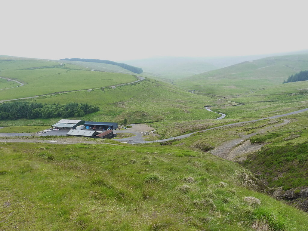
Most of both mines has been destroyed. The eastern dressing floors were cleared for farm buildings and parking, and a rally school has since used the ground; modern sheds stood on the site in 2025. The western workings are partly lost in trees.
On the east, two shafts, two levels, a dam and a possible reservoir. On the west, an ore bin and a shaft, with the footings of the cottages, an office and a smithy or carpenter's shop at foundation level.
Redevelopment
The eastern dressing floors were cleared for farm buildings and parking.
Related mines
- Nanty Mine — The eastern Wye Valley mine was first worked as West Nanty, a company of that name sharing a director and secretary with the Nanty company in 1863, and the two mines were offered for sale together in 1867.
Nearby mines
- Nantiago Mine — 0.7 miles (1.2 km) N
- Plynlimmon Mine — 0.7 miles (1.2 km) N, Ceredigion
- Nant yr Eira Mine — 1.4 miles (2.2 km) N
- Cwm Ricket Mine — 1.9 miles (3.1 km) NE
- Nanty Mine — 2.5 miles (4.0 km) SE
Straight-line distance, within 9 miles (15 km). Show on the map.
Further reading
The archaeological trust's survey of the eastern mine, with a 2003 note on how much has been destroyed.
View sourceThe archaeological trust's survey of the western mine: shafts, adit, wheel, leat and cottages.
View sourceSources
- (primary) Lead and Zinc: The Mining District of North Cardiganshire and West Montgomeryshire (Special Reports on the Mineral Resources of Great Britain, vol. XX), O. T. Jones, 1922 — Memoirs of the Geological Survey
- (secondary) The Wye Valley and Nantiago mines: historical account in Cambrian Archaeological Projects report 424 (archive document cap424_071) — Coflein, Royal Commission on the Ancient and Historical Monuments of Wales
- (secondary) Powys Metal Mines Survey: Wye Valley (HER 18979) — Clwyd-Powys Archaeological Trust, Powys Metal Mines Survey
- (secondary) Powys Metal Mines Survey: West Wye Valley (HER 8474) — Clwyd-Powys Archaeological Trust, Powys Metal Mines Survey
- (observational) Modern buildings on the site of the Wye Valley Mine (Geograph photograph 8135239, 2025) — Geograph
Record created: 18 November 2026 · Last researched: 18 November 2026