 MineArchive
Nant yr Eira Mine
| Also known as | Snowbrook Mine, Nantyreira Mine, Snow Brook Mine, Nant-yr-Eira Mine |
|---|---|
| Location | Nant yr Eira, on the north-east side of Pumlumon Fawr, Llangurig, Powys — 52.4710, -3.7282 (exact) |
| Commodities | Lead, Copper |
| Type | Metal |
| Worked | Bronze Age–1883 |
Nant yr Eira, known in English as Snowbrook, is a mine at about 500 metres on the north-east side of Pumlumon, three-quarters of a mile north of Nantiago. Its deep opencut along the stream was first dug in the Bronze Age, apparently for copper, and has given stone tools, charcoal and radiocarbon dates to prove it. The cut was found again in 1858 and worked for lead until 1883, though it returned only 161 tons of ore. It is a scheduled monument.
Location
Recorded location. The large pin is this mine; the small round markers are the nearest mines on record. Click one for its page. View on full map
History
The lode here is a north-south fissure carrying galena, silver and some copper pyrites, and the oldest working on it is an opencut some 90 metres long that follows the course of the stream. Excavation in its waste has turned up stone mining tools, ore and charcoal, and the charcoal has been radiocarbon-dated to the Bronze Age.
The Victorians found the cut when it was cleared out in 1858 and 1859. At 50 feet down the men came on two or three small picks and wedges, which were sent to Sir Hugh Williams of Bodelwyddan and given by him to the Duke of Northumberland. Three pieces were later to be seen at Alnwick Castle: an iron pick with a wooden handle, a broken piece of stag's horn worn smooth at one end, and a round, smooth stone ball between three and four inches across. The finds were put down to the Romans at the time, though there is no other sign of Romans in the district. The waste also holds a great deal of charcoal and burnt stone.
As a lead mine it never amounted to much. Ore was returned in 1859 and 1860 and again in 1879, 1880, 1882 and 1883, the best year being 37 tons in 1880, and the whole output was 161 tons. A waterwheel fed from a reservoir up the valley drove the crusher. The neighbouring Hore workings were later counted as part of the same mine.
Geology
A nearly vertical north-south fissure cuts the upper grit beds of the Lower Van formation, west of the anticline on which Nantiago lies. Narrow strings of galena show in the joints of the grits, and the lode also carries chalcopyrite in a quartz gangue.
Geological setting: Veins and Lodes (well documented example)
Workings
The prehistoric opencut lies on the lode north of the dressing floors, with a nineteenth-century shaft sunk through its floor at the south end. The stream was once turned round the head of the cut in a leat and now falls into it. The main shaft is east of the dressing floors, another stands near the source of the stream to the north-west, and there are many trials on the hillside to the east. In a separate area to the north are a reservoir with a stone dam, two adits, a trial adit and a rock-cut level.
Closure
Mining resumed in 1858 and ended in 1883, the last year for which ore was returned.
What remains
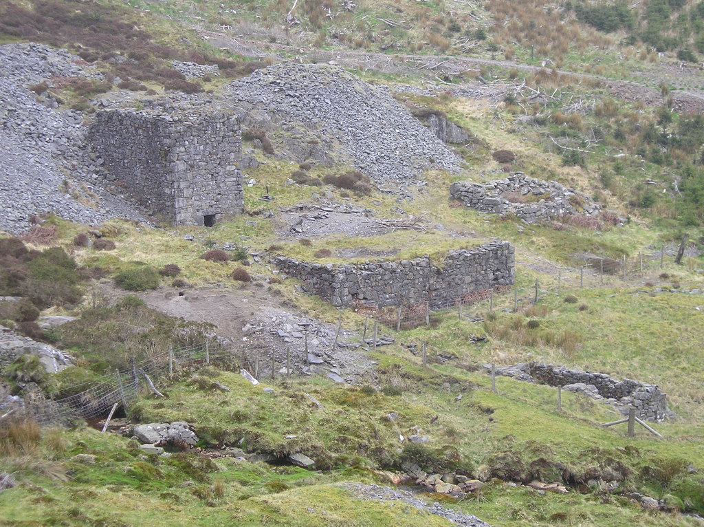
The site lies on the edge of forestry and is scheduled in two areas. The crusher house stood to its full height in 2010, with the dry-stone walls of the dressing floor and banks of waste around it.
A crusher house and its wheelpit, a second wheelpit, two round buddles, ore bins with a picking platform, the low walls of a square building that was an office or a smithy, two tramway banks, a leat, a magazine on the hillside to the south-east, large waste tips, and the reservoir and dam to the north.
Nearby mines
- Nantiago Mine — 0.6 miles (1.0 km) S
- Plynlimmon Mine — 0.6 miles (1.0 km) S, Ceredigion
- Wye Valley Mine — 1.4 miles (2.2 km) S
- Cwm Ricket Mine — 1.7 miles (2.7 km) E
- Nantmelin Mine — 2.1 miles (3.3 km) E
Straight-line distance, within 9 miles (15 km). Show on the map.
Further reading
The Royal Commission's site record, describing the two areas of remains and the excavated opencut.
View sourceThe archaeological trust's field survey of 1992-93, with grid references for the opencut, shafts, wheelpits and magazine.
View sourceSources
- (primary) Nant-yr-Eira Mine; Snow Brook Mine; Hore Mine (NPRN 34005) — Coflein, Royal Commission on the Ancient and Historical Monuments of Wales
- (primary) Scheduled Monument MG226: Nant yr Eira Prehistoric Copper Mines and 19th Century Lead Mine — Cadw
- (secondary) Powys Metal Mines Survey: introduction — Clwyd-Powys Archaeological Trust, Powys Metal Mines Survey
- (primary) Lead and Zinc: The Mining District of North Cardiganshire and West Montgomeryshire (Special Reports on the Mineral Resources of Great Britain, vol. XX), O. T. Jones, 1922 — Memoirs of the Geological Survey
- (secondary) Powys Metal Mines Survey: Nant yr Eira (HER 725) — Clwyd-Powys Archaeological Trust, Powys Metal Mines Survey
- (primary) Hore Mine, Workings (NPRN 33999) — Coflein, Royal Commission on the Ancient and Historical Monuments of Wales
- (observational) Nant yr Eira Mine (Geograph photograph 1899693, 2010) — Geograph
Record created: 18 November 2026 · Last researched: 18 November 2026