 MineArchive
Wheal Peevor
| Location | Scorrier, near Redruth, Cornwall — 50.2533, -5.2167 (exact) |
|---|---|
| Commodities | Tin, Copper, Tungsten |
| Type | Metal |
| Worked | c. 1701–1950s |
| Maximum depth | c. 100 metres (Great County Adit) |
| Operators | St Aubyn family (1701–?) |
Overview
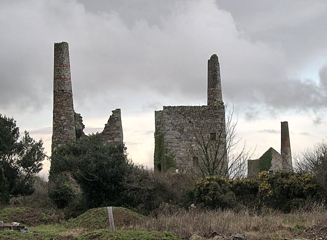
Wheal Peevor, on the edge of Redruth, is one of Cornwall's most photographed mining sites — a rare surviving three-engine-house arrangement, one engine each for pumping, hauling and crushing, on a single compact site.
History
Wheal Peevor's first mining sett was granted around 1701 on land owned by the St Aubyn family, and the mine was worked from the mid-18th century for copper at shallow depths, proving troublesomely wet and requiring three Newcomen-type engines to keep it drained. When copper prices collapsed after 1788 the mine turned to tin, found at greater depth, and the deep Great County Adit, reaching around 100 metres, was driven to help drain the workings. Wheal Peevor's most productive period came after it was separated from the neighbouring Great North Downs mine in 1872: rebuilt with modern engines, it became, in the words of one contemporary account, 'the surprise of Cornish mining', remaining profitable through the 1870s and 1880s while many neighbouring mines struggled, and employing up to 300 miners at its 1880 peak. Between 1872 and 1889 the mine produced around 3,280 tons of black tin alongside smaller quantities of copper ore, pyrite and arsenopyrite. A collapse in tin prices caused by new discoveries in the Far East brought about closure in 1889. A company reopened the mine in 1911-12, working it for tin and tungsten, but this too closed by 1918, and further attempts to revive the mine in 1938 and the 1950s also failed. The output that earned the mine its reputation was, by Dines's figures, 3,280 tons of black tin between 1872 and 1889 with only 5 tons of copper ore, 7 tons of pyrite and 12 tons of arsenopyrite beside it; the 1912-18 reopening added 14 tons of black tin and a little wolfram. Kerrier Council acquired the site in 2005, and the abandonment plans of Wheal Peevor and West Peevor were lost in transit on British Rail in 1969, so that the surviving record of the workings is a scanned Scorrier district plan and two shaft sections at West Peevor.
Geology
The mine worked copper and tin lodes of the Camborne-Redruth mining district, part of the granite-related hydrothermal mineralisation of central Cornwall, worked first at shallow depth for copper and later, once the Great County Adit had improved drainage, for tin found deeper in the same lode system.
Geological setting: Hydrothermal Deposits (well documented example), Veins and Lodes (well documented example)
Workings
The mine's three surviving engine houses each served a different function — pumping, hauling (winching) and ore crushing (stamping) — a rare case of a complete set of mine engine functions preserved together on one compact site; the deep Great County Adit, reaching around 100 metres, provided drainage that allowed the transition from shallow copper working to deeper tin extraction.
Closure
A collapse in tin prices, driven by new Far Eastern discoveries, closed the mine in 1889; reopening attempts in 1911-12 (closing 1918), 1938 and the 1950s all subsequently failed.
What remains
Since 2003 more than £800,000 has been invested in restoring the site, which opened to the public in January 2008 and now forms part of the Cornwall and West Devon Mining Landscape UNESCO World Heritage Site, with a multi-use trail around the surviving engine houses.
Three engine houses survive together on the site — housing a 72-inch pumping engine, a winching engine, and a 32-inch Californian stamps engine — one of Cornwall's most complete and most photographed surviving mine engine-house groups.
Related mines
- Great County Adit — The Great County Adit was driven to help drain Wheal Peevor's workings, reaching around 100 metres deep.
- North Downs Mine — The two mines shared the Peevor lode and were worked jointly in Great North Downs' later years.
Nearby mines
- North Downs Mine — 0.5 miles (0.8 km) E
- Treskerby Mine — 0.6 miles (1.0 km) SE
- Wheal Harmony — 0.7 miles (1.2 km) SW
- Hallenbeagle Mine — 1.2 miles (1.9 km) E
- Wheal Grambler — 1.3 miles (2.1 km) SE
Straight-line distance, within 9 miles (15 km). Show on the map.
Recorded claims
Individual factual claims, each attached to the source(s) that support it below. Where sources disagree, both are kept.
- Between 1872 and 1889 the mine produced around 3,280 tons of black tin, employing up to 300 miners at its 1880 peak. 1
- Three engine houses survive on the site, housing a 72-inch pumping engine, a winching engine, and a 32-inch Californian stamps engine. 1,2
- Wheal Peevor was worked for copper at shallow depth from 1790 as part of its eastern neighbour Great North Downs; between 1872 and 1889 it returned 3,280 tons of black tin, 5 tons of 4% copper ore, 7 tons of pyrite and 12 tons of arsenopyrite, and in 1912-17 5 tons of black tin with mixed wolfram concentrates, then 9 tons of black tin and 3.5 cwt of wolfram in 1918, the figures from Dines (1956). Kerrier Council acquired the site in 2005 with a grant to preserve the buildings. 3
- In 1911 a company acquired the mine property hoping to reopen it, planning to work the surface ground first and then unwater the mine; only a small amount of tin and tungsten was produced before closure in 1918. Since 2003 more than £800,000 has been spent preserving the buildings, and the site opened to the public in January 2008. 1
- The British Geological Survey's catalogue records the Wheal Peevor and Wheal Peevor West abandonment plans (tin and copper ores, OM3059) as lost in transit with British Rail on 2 June 1969, and holds a scanned Scorrier district plan of West Peevor Mine (MP23619) and transverse sections through Michell's and Sir Frederick's engine shafts at West Peevor (MP24853, MP24854). 4
- Located at about 50.253 N, 5.217 W. 1
Sources
- (secondary) Wheal Peevor — Wikipedia
- (primary) Part of the mining complex at Wheal Peevor, Redruth — Historic England (Scheduled Monument record)
- (secondary) Wheal Peevor Mine, Redruth, Cornwall (Cornwall Calling) — Cornwall Calling
- (primary) Wheal Peevor and Wheal Peevor West mine plans — British Geological Survey / The Coal Authority
Record created: 24 August 2026 · Last researched: 24 September 2026