 MineArchive
Wenvoe Quarry
| Also known as | Alps Quarry |
|---|---|
| Location | The Alps, between Wenvoe, Culverhouse Cross and Caerau, Vale of Glamorgan — 51.4590, -3.2480 (exact) |
| Commodity | Limestone |
| Type | Quarry |
| Worked | 1880s–2023 (an earlier phase ended by 1915) |
| Maximum depth | Unknown. |
| Operators | Amalgamated Aggregates (1976–?), Breedon Group (?–2023) |
Overview
Wenvoe Quarry, long known as Alps Quarry, worked Carboniferous limestone from a ridge on the eastern edge of the Vale of Glamorgan, some five kilometres south-west of Cardiff. It has had two working lives. The first began in the 1880s, supplying stone for the building of Barry Docks and employing around two hundred men at its height, and had finished by 1915. The second began in 1976 and ran continuously under a succession of owners until production ceased at the end of 2023.
History
An Ordnance Survey six-inch map surveyed in 1878–79 shows only small quarry workings and a lime kiln alongside what became Alps Quarry Road. Commercial-scale operations began in the 1880s, and the quarry became an important source of stone for construction in the area — most notably for the building of No. 1 Dock at Barry Docks, the works that made Barry a coal port. By 1889 the quarry employed some two hundred men. In August of that year three of them were killed by a single fall of stone.
A revision of the same Ordnance Survey sheet in 1898 shows the workings much expanded, with several tramways inside the quarry. Stone went down an inclined tramway to be loaded onto wagons of the Barry Railway near the southern portal of the Wenvoe Tunnel, and waste rock was tipped on ground on several sides of the quarry. That first working life did not last: the 1915 revision of the map records simply "Alps Quarry (disused)".
Commercial quarrying was resumed in 1976 by Amalgamated Aggregates, which developed a new extraction area at the eastern margin of the site. Working continued without a break from then, under a succession of operating companies, until production ceased at the end of 2023. The quarry is managed by the Breedon Group; the mineral rights belong to the Wenvoe Castle Estate.
The modern working cost the site some of its older history. Coed-y-Cymdda, an earthwork hill-slope enclosure of the late Bronze Age on the south-west flank of the same ridge, was excavated ahead of its destruction by quarrying in 1978–80; the finds indicated activity on the site into the Roman period. In 1979 the quarry broke into the underground workings of the small Wenvoe iron ore mine on the north-east flank of the ridge, which had worked haematite intermittently in the middle and later nineteenth century by both opencast and underground methods.
Geology
The quarry worked Carboniferous limestone of the Friar's Point Limestone Formation, which lies towards the upper boundary of the Black Rock Limestone Subgroup within the Pembroke Limestone Group, and was deposited between about 358.9 and 344.5 million years ago. The worked ground is an inlier — a window of older rock surrounded by the younger Mercia Mudstone Group — whose eastern edge is bounded by the Penarth Fault.
The formation is around 265 metres thick here and dips at roughly thirty degrees to the west. Because the limestone is more durable than the surrounding mudstone, and because of that westward dip against the sharp fault boundary to the east, it stands out as a prominent ridge running roughly north-north-west to south-south-east, rising as much as sixty metres above the ground around it, with a moderately steep escarpment along its eastern edge. Within the quarry boundary the limestone is covered by as little as five centimetres of soil. Water off the ridge drains east to the Bullcroft Brook and west to the headwaters of the Wrinstone Brook, which join downstream as the Cadoxton River and reach the Bristol Channel at The Bendricks near Barry.
Geological setting: Faults and Fractures (well documented example), Strike and Dip (well documented example)
Workings
An open quarry on the flank and crest of the limestone ridge, worked in two areas connected by a tunnel. The most recent extraction was at the eastern margin; the older workings at the western margin were latterly used for processing rock and stockpiling aggregate. In the nineteenth-century phase the quarry was served by internal tramways, with an incline carrying stone down to the Barry Railway near the southern portal of the Wenvoe Tunnel, and waste tipped on ground around the site. The shallow soil cover — as little as five centimetres over the limestone — made the rock unusually easy to get at.
Closure
The quarry has not been in production since the end of 2023. No source states a reason, and no restoration scheme was found. This is the second time the site has stopped: the first working life, begun in the 1880s, was over by 1915, when the Ordnance Survey recorded the quarry as disused, and it stood idle for some sixty years before quarrying resumed in 1976.
What remains
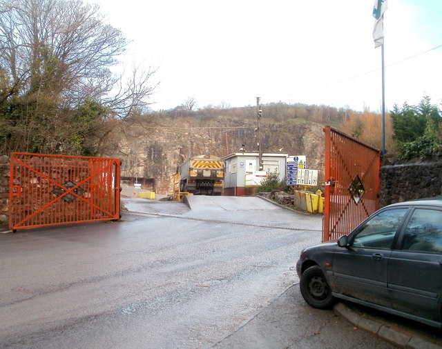
The quarry is out of production but not abandoned in the derelict sense: it remains managed by the Breedon Group, and the processing and stockpiling areas at the western margin are part of a working industrial site. It is bounded on all sides by agricultural fields and dense woodland, and photographs from the lanes around it — including one taken in November 2010 — show the workings largely screened by trees. A pair of lime kilns, presumably those recorded on the 1885 map, stand next to the quarry entrance; their draw arches have been re-faced and built into the quarry wall, though the chambers have partly collapsed.
A pair of lime kilns beside the quarry entrance, their draw arches re-faced and incorporated into the quarry wall and their chambers partly collapsed. Nearby, though not part of the quarry, the southern portal and bore of the Wenvoe Tunnel survive from the Barry Railway that the quarry's incline once fed.
Related mines
- Wenvoe Iron Mine — In 1979 the advancing Alps Quarry broke directly into the old underground workings of the Wenvoe iron ore mine on the north-east flank of the same limestone ridge — a physical connection between the two, not merely a shared location.
Nearby mines
- Wenvoe Iron Mine — 0.1 miles (0.1 km) NE
- Penylan Quarry — 4.9 miles (7.9 km) NE, Cardiff
- Little Garth Mine — 5.2 miles (8.4 km) N, Cardiff
- Lan Colliery — 5.9 miles (9.4 km) N, Cardiff
- Rumney Quarry — 5.8 miles (9.4 km) NE, Cardiff
Straight-line distance, within 9 miles (15 km). Show on the map.
Disasters & major incidents
-
Alps Quarry Fall of Stone, 1889
15 August 1889 · Collapse / Roof Fall · 3 fatalities
At around midday on 15 August 1889 three men were killed at Alps Quarry, Wenvoe, while boring a shot hole about ten feet from the quarry face. Large boulders came down on them and they fell some sixty feet to the quarry bottom, where they were crushed. The inquest at Cardiff returned a verdict of accidental death.
Recorded claims
Individual factual claims, each attached to the source(s) that support it below. Where sources disagree, both are kept.
- An Ordnance Survey six-inch map surveyed in 1878-79 shows only small quarry workings and a lime kiln beside what became Alps Quarry Road; commercial-scale operations began in the 1880s. 1
- The quarry was an important source of stone for construction projects including the building of No. 1 Dock at Barry Docks. 1
- In 1889 the quarry employed some 200 men. 1
- A revised Ordnance Survey map of 1915 records the site as "Alps Quarry (disused)". 1
- Commercial quarrying was resumed by Amalgamated Aggregates in 1976 with the development of the eastern extraction area, and continued under various operating companies until production ceased at the end of 2023. 1
- The quarry worked the Friar's Point Limestone Formation, near the top of the Black Rock Limestone Subgroup of the Pembroke Limestone Group, about 265 m thick here and dipping some 30 degrees to the west, exposed as an inlier bounded on its eastern side by the Penarth Fault. 1
- In 1979, as quarrying progressed, the Alps Quarry broke into the underground workings of the Wenvoe iron ore mine, which had worked haematite intermittently in the mid to late 1800s by both opencast and underground methods. 1
- Coed-y-Cymdda, a late Bronze Age earthwork hill-slope enclosure on the ridge, was excavated ahead of its destruction by quarrying in 1978-80; the finds indicated activity on the site until the Roman period. 1
- A photograph taken from the lanes north of the quarry in November 2010 shows the workings screened almost entirely by the belt of woodland around them. 2
- Three men were killed by a fall of stone at the quarry on 15 August 1889; the inquest at Cardiff returned a verdict of accidental death. 1,3
Photographs & further reading
A November 2010 photograph looking towards the quarry from the lanes around it, showing how completely the workings are screened by the surrounding woodland.
View sourceSources
- (secondary) Wenvoe Quarry — Wikipedia
- (observational) Wenvoe Quarry (photograph, November 2010) — Geograph Britain and Ireland
- (secondary) Wales — newspaper accounts of nineteenth-century accidental deaths — Death On My Doorstep
Record created: 4 September 2026 · Last researched: 5 September 2026