 MineArchive
Thrislington Colliery
| Also known as | West Cornforth Colliery |
|---|---|
| Location | West Cornforth, County Durham — 54.6991, -1.5225 (approximate) |
| Commodity | Coal |
| Type | Coal |
| Worked | From 1835–4 March 1967 |
| Maximum depth | 948 feet at the Jane Pit (1867 sinking log) |
| Operators | Rosedale and Ferryhill Iron Company (1867–1879), Thrislington Coal Company (1879–1914), North Bitchburn Coal Company (1914–1932), Henry Stobart & Co. Ltd (1932–1947), National Coal Board (1947–1967) |
Overview
A County Durham colliery between Ferryhill and Cornforth, bored from 1835, sunk from 1840 and worked until March 1967. Known equally as West Cornforth Colliery, it was the reason the village of West Cornforth exists. The Jane Pit of 1867 was sunk through 948 feet of strata to the Brockwell seam. Ownership passed through the Rosedale and Ferryhill Iron Company, the Thrislington Coal Company, the North Bitchburn Coal Company and Henry Stobart & Co. before nationalisation, and employment peaked at 1,155 in 1947. The site is now Thrislington Quarry.
History
Boring began from the surface at Thrislington in 1835 and proved the sequence down to the Bottom Hutton seam. Sinking followed from 15 April 1840, reaching the Main Coal, and a seam was won in 1844. A borehole of 1851 put down to the Harvey seam proved the Old Main Coal already worked out. The Mary Pit and the Jane Pit were both sunk in 1867, the Jane going down to the Brockwell.
The Rosedale and Ferryhill Iron Company held the colliery from 1867, the Thrislington Coal Company from 1879, the North Bitchburn Coal Company from 1914 and Henry Stobart & Co. Ltd from 1932, before it passed to the National Coal Board in 1947. Whellan's 1894 Directory of County Durham found the Harvey the only seam then worked, four feet thick at a depth of 103 fathoms, producing about 450 tons a day of which a quarter was made into coke, and employing 450 men and boys. Most of the heapstead was destroyed by fire in 1911.
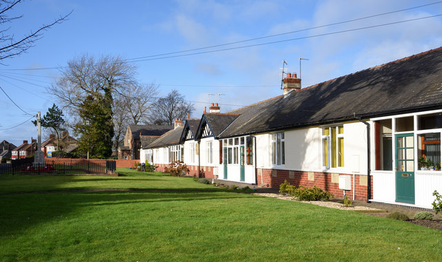
The workforce grew steadily — 322 in 1894, 741 in 1910, 951 in 1925 — and peaked at 1,155 in 1947, of whom 867 worked below ground. The village of West Cornforth, dating from 1857, grew with the colliery and shrank after it. In 1925 the company built a row of retirement bungalows for its miners at Cornforth, which still stand beside the village war memorial. At least 89 men are known by name to have died from their work at the colliery; falls of stone account for most of them, and several died months or years later of injuries or of illness the coroner found had been accelerated by their work underground.
Geology
The colliery worked the Coal Measures of east Durham beneath the Magnesian Limestone escarpment. The 1867 sinking log for the Jane Pit, from a surface about 410 feet above Ordnance datum, runs through 948 feet of strata to reach the Brockwell. Whellan's 1894 Directory records the Harvey seam four feet thick at 103 fathoms, with the Low Main at two feet six inches, the Hutton at one foot ten inches and the Brockwell also present. For most of its life the colliery worked just the Busty and the Harvey; only after nationalisation do the returns widen to the Brockwell, Five Quarter, Hutton, Low Main, Main Coal, Top Busty and Yard as well. The limestone above the coalfield is what the site is worked for now.
Geological setting: Sedimentary Beds and Seams (well documented example)
Workings
Two named pits, the Mary and the Jane, both sunk in 1867, alongside the original 1840 shaft to the Main Coal. The Jane Pit's sinking log records 948 feet of strata. Coal was hewn at the face and drawn by set and rope; the inspectors' accounts of deaths describe stone falling from between converging slips in the blue shale directly over the Harvey seam, men caught by sets on the roads, and putters crushed by tubs. About a quarter of the output was made into coke on site in the 1890s. Most of the heapstead burned down in 1911. The Five Quarter seam was discontinued in 1950.
Closure
The Five Quarter seam was discontinued in 1950. The colliery closed on 4 March 1967, with 427 people employed, and salvage work continued into 1968. West Cornforth lost the industry it had grown up around; its railway station had already closed in 1952.
What remains
Much of the colliery take is now occupied by Tarmac's Thrislington Quarry and concrete works, which extract the Magnesian Limestone above the old coal workings; south of the quarry lies Thrislington Plantation National Nature Reserve, an area of limestone grassland and an SSSI. In the village, the row of miners' retirement bungalows the colliery provided in 1925 survives on the green beside the Cornforth war memorial, identified by a pale plaque at the centre of the terrace; a photograph of February 2020 shows them white-rendered above red brick, lived in and well kept.
No colliery structures. The 1925 miners' retirement bungalows at Cornforth survive in use, and the colliery ground itself is worked as Thrislington Quarry.
Redevelopment
The site became Thrislington Quarry, a working limestone quarry and concrete works, with Thrislington Plantation National Nature Reserve immediately to its south.
Related mines
- Chilton Colliery — Both were worked by Henry Stobart & Co. Ltd, which took Thrislington over in 1932.
- Fishburn Colliery — Both were worked by Henry Stobart & Co. Ltd, which took Thrislington over in 1932.
Nearby mines
- East Howle Colliery — 1.1 miles (1.7 km) W
- Metal Bridge Drift — 1.3 miles (2.2 km) NW
- Tursdale Colliery — 1.4 miles (2.2 km) N
- Dean and Chapter Colliery — 1.4 miles (2.3 km) SW
- Mainsforth Colliery — 1.4 miles (2.3 km) S
Straight-line distance, within 9 miles (15 km). Show on the map.
Recorded claims
Individual factual claims, each attached to the source(s) that support it below. Where sources disagree, both are kept.
- Boring began from the surface at Thrislington in 1835, proving down to the Bottom Hutton seam; sinking to the Main Coal followed from 15 April 1840. 1
- The Jane Pit, sunk in 1867 from a surface about 410 feet above Ordnance datum, was logged through 948 feet of strata to the Brockwell seam. 2
- The colliery passed from the Rosedale and Ferryhill Iron Co. (1867) to the Thrislington Coal Co. (1879), the North Bitchburn Coal Co. (1914), Henry Stobart & Co. Ltd (1932) and the National Coal Board (1947). 1
- Whellan's 1894 Directory records the Harvey as the only seam then worked, four feet thick at 103 fathoms, producing about 450 tons a day, a quarter of it made into coke, and employing 450 men and boys. 1
- Employment peaked at 1,155 in 1947, 867 of them below ground, and had fallen to 427 by the closure in 1967. 1,3
- Most of the heapstead was destroyed by fire in 1911. 1
- A plaque at the centre of a run of bungalows on the green at Cornforth records that the homes were provided by Thrislington Colliery in 1925; they were still in use when photographed in February 2020. 4
- Much of the area is now used by Tarmac's Thrislington Quarry and concrete works, with Thrislington Plantation National Nature Reserve, an SSSI of limestone grassland, to the south. 3,5
- The BGS mine-plans catalogue holds a Mining Remediation Authority abandonment plan titled 'Thrislington' (catalogue D1148, Bottom Hutton 'L2', dated 1967). 6
Photographs & further reading
Pits, owners, seams and employment returns from 1883 to 1968, Whellan's 1894 account of the colliery, and the museum's list of men killed there with the inspectors' notes.
View sourceA short history of the township and its colliery, with the quarry and nature reserve that occupy the ground today and links to local photographs.
View sourceThe full sinking log of the Jane Pit, bed by bed through 948 feet to the Brockwell seam, from the Institute's Borings and Sinkings volumes.
View sourceSources
- (primary) Thrislington Colliery — Durham Mining Museum
- (primary) Strata sunk through at the Jane Pit, Thrislington Colliery, 1867 (An Account of the strata of Northumberland & Durham as proved by Borings & Sinkings, Volume S-T, 1894, sinking no. 1996) — North of England Institute of Mining & Mechanical Engineers, via the Durham Mining Museum
- (secondary) Thrislington — Co-Curate, Newcastle University
- (observational) Miners' retirement homes, Cornforth (photograph, 1 February 2020) — Geograph Britain and Ireland
- (secondary) West Cornforth — Wikipedia
- (primary) BGS / Mining Remediation Authority mine plans: THRISLINGTON — British Geological Survey / Mining Remediation Authority
Record created: 3 September 2026 · Last researched: 4 September 2026