 MineArchive
Tursdale Colliery
| Location | Tursdale, near Cornforth and Bowburn, County Durham — 54.7176, -1.5335 (approximate) |
|---|---|
| Commodity | Coal |
| Type | Coal |
| Worked | 1854 (boring)–May 1966 |
| Maximum depth | About 672 feet (Brockwell seam, 1859 section) |
| Operators | Bell Brothers (1859–1923), Dorman, Long & Co. Ltd. (1923–1947), National Coal Board (1947–1966) |
Overview
A Bell Brothers colliery near Cornforth, sunk to the Busty seam in 1859 with its own coke ovens, merged with Bowburn in 1931 and closed as the Tursdale End of Bowburn in 1966.
History
Tursdale Colliery stood at Tursdale, in the township of Cassop-cum-Quarrington about four and a half miles south-south-east of Durham. Boring on the Tursdale estate proved the Busty seam in 1854, the year local histories give for the colliery's opening, and the shaft was sunk from the surface to the Busty in 1859. A staple sunk below the Busty in 1867 proved the lower coals. Bell Brothers owned it from the 1860s, with W. Ramsay as manager in the 1880s and 1890s and John Ramsay after him.
In 1894 about 700 men and boys worked the Busty seam at 100 fathoms. The daily output averaged about 760 tons, and half of it was made into coke in 211 ovens on the spot. The coal went mainly to industry. Employment rose from 413 in 1883 to 883 in 1905.
Dorman, Long and Co. took over in April 1923, when they also owned the neighbouring Bowburn Colliery, and employment reached 993 in 1925. In 1931 Tursdale was merged with Bowburn and its shaft kept as a man-riding shaft for the combined colliery. The National Coal Board took over in 1947. The Board announced on 10 March 1966 that the whole Tursdale End would close in the week ending 21 May 1966; Bowburn itself drew its last coal on 20 July 1967. The Durham Mining Museum gives 1968 for Tursdale's closure, the year the downcast headgear came down.
The houses of Tursdale, other than the farms, were built for the colliery's miners.
Geology
Durham Coal Measures. The shaft section of 1859 reached the Harvey seam at about 408 feet, the Busty, 5 feet 6 inches, at about 549 feet and the Brockwell, 4 feet, at about 672 feet, beneath clay, sand and gravel with water. In 1894 the Busty averaged four feet with an ironstone band and a sagger band; the Main coal, Harvey, Busty and Brockwell were all worked, with fireclay. Part of the royalty lay north of the Hett Whin Dyke.
Geological setting: Dykes and Sills (historical documentary reference)
Workings
A shaft sunk in 1859 to the Busty seam, with a staple sunk below it in 1867, and a bank of 211 coke ovens by 1894. The Main seam workings at Hett Gill were abandoned on 31 January 1909. After the 1931 merger the shaft served Bowburn for man-riding, and the Tursdale districts, the Tursdale Harvey and the Pastures, were worked as part of Bowburn Colliery.
Closure
The National Coal Board closed the Tursdale End of Bowburn Colliery in the week ending 21 May 1966. Bowburn followed in July 1967, and demolition of the Tursdale downcast headgear began on 27 February 1968.
What remains
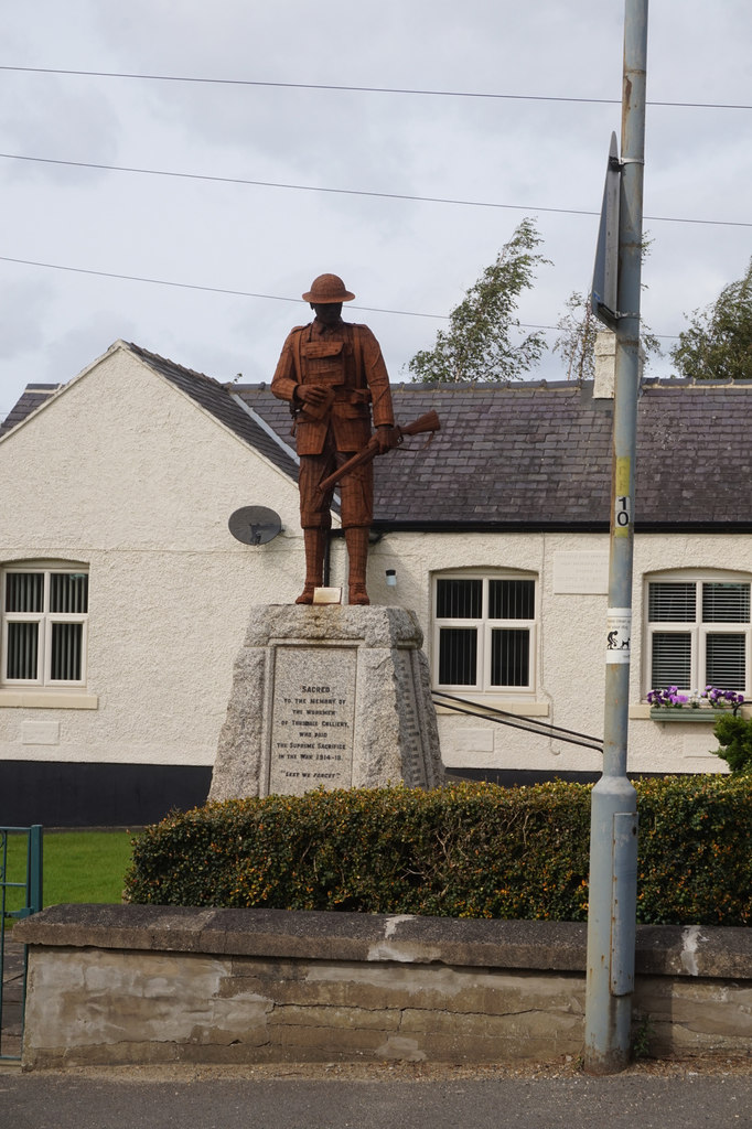
The colliery site is an industrial estate, and the road that once led to it is now a short cul-de-sac off Thinford Road. The colliery's First World War memorial, a figure of a soldier on a stone plinth, stands on Thinford Road.
Redevelopment
After closure the National Coal Board's Tursdale Workshops on the site served first the region and then the whole Board until 1994. The colliery and workshop site had been redeveloped as an industrial estate by 2006.
Related mines
- Bowburn Colliery — Merged with Bowburn in 1931; Tursdale's shaft became Bowburn's man-riding shaft and its districts were worked as the Tursdale End until 1966. Both were Dorman, Long collieries from 1923.
Nearby mines
- Bowburn Colliery — 1.2 miles (2.0 km) N
- Thrislington Colliery — 1.4 miles (2.2 km) S
- Tudhoe Whinstone Mine — 1.8 miles (2.9 km) W
- Tudhoe Colliery — 2.0 miles (3.2 km) W
- Dean and Chapter Colliery — 2.1 miles (3.4 km) S
Straight-line distance, within 9 miles (15 km). Show on the map.
What's uncertain
Points where sources disagree or the record could not be settled; both accounts are kept. All open questions in the archive.
- Tursdale Colliery was opened in 1854 and produced coal until 1968, employing over 800 men at its height. (uncertain) 3
- Tursdale Colliery closed in 1968. (disputed) 1
Recorded claims
Individual factual claims, each attached to the source(s) that support it below. Where sources disagree, both are kept.
- Boring from the surface on the Tursdale estate proved the Busty seam in 1854, and the colliery was sunk to the Busty in 1859. 1,2
- Tursdale Colliery was opened in 1854 and produced coal until 1968, employing over 800 men at its height. (uncertain) 3
- Bell Brothers owned the colliery from the 1860s, and Dorman, Long and Co. from April 1923 until nationalisation in 1947. 1,2
- In 1894 about 700 men and boys worked the Busty seam at 100 fathoms, raising about 760 tons a day, half of it coked in 211 ovens on site. 1
- The 1859 section of strata reached the Busty seam at 548 feet 9 inches and the Brockwell at 671 feet 9 inches. 4
- Employment was 413 in 1883, 883 in 1905 and 993 in 1925. 1
- The Main seam at Hett Gill, Tursdale, was abandoned on 31 January 1909. 5,6
- Tursdale Colliery was merged with Bowburn Colliery in 1931. 7,8
- The NCB announced on 10 March 1966 that the whole Tursdale End of Bowburn Colliery would close with effect from the week ending 21 May 1966. 7
- Tursdale Colliery closed in 1968. (disputed) 1
- Demolition of the Tursdale downcast pit gear began on 27 February 1968. 7
- After Bowburn closed in 1967 the NCB Tursdale Workshops served the region and then the whole Board until they closed in 1994. 8
- W. Ramsay was manager from the 1880s to 1902 with J. Ramsay as under-manager, and John Ramsay was manager from 1905. 9
- The road that once led to Tursdale Colliery is now about 75 metres long. 10
Photographs & further reading
Photographs from 2020 of the colliery's First World War memorial on Thinford Road.
View sourceOwners, output, employment and seams from 1860 to 1930, the 1894 directory description and the names of those killed.
View sourceA long history of Bowburn Colliery that covers the Tursdale merger of 1931 and the closure of the Tursdale End in 1966.
View sourceThe record office's colliery entry, with its owners and the directories and inspectors' reports that list it.
View sourceSources
- (primary) Durham Mining Museum - Tursdale Colliery — Durham Mining Museum
- (secondary) Durham Collieries: Tursdale Colliery — Durham County Record Office
- (secondary) Keys to the Past: Tursdale (County Durham), D6899 — Durham County Council and Northumberland County Council
- (primary) Durham Mining Museum - Tursdale Colliery: section of strata, 1859 — Durham Mining Museum
- (primary) Durham Mining Museum - Catalogue of plans of abandoned mines for Tursdale Colliery — Durham Mining Museum
- (primary) BGS mine plans: Tursdale (Main seam, abandoned 1909) — British Geological Survey / Mining Remediation Authority
- (secondary) A history of Bowburn Colliery - Bowburn Local History — Bowburn Local History
- (secondary) Tursdale — Wikipedia
- (primary) Durham Mining Museum - Tursdale Colliery: colliery management — Durham Mining Museum
- (observational) Cul-de-sac from Thinford Road (Geograph, Derek Harper, 2019) — Geograph
Record created: 1 October 2026 · Last researched: 1 October 2026