 MineArchive
Threlkeld Quarry and Mine
| Location | Threlkeld, three miles east of Keswick, Cumbria — 54.6131, -3.0469 (approximate) |
|---|---|
| Commodities | Granite, Barite, Lead, Zinc |
| Type | Stone |
| Worked | 1870–1982 |
| Operators | H. Harkewitz / Threlkeld Granite Company (1870–1936), Keswick Granite Company (1936–1982) |
Overview
Threlkeld, three miles east of Keswick, was worked for over a century as a microgranite quarry — and, on the same hillside, for lead and zinc since the 17th century — before closing in 1982 and reopening as the Lake District's mining museum.
History
The granite quarry was founded in the 1870s by H. Harkewitz, an entrepreneur of German descent, to supply railway ballast for the Penrith-Keswick line; output grew from a few hundred tons a year to 80,000 tons by 1894, as the stone found further markets supplying Manchester Corporation Waterworks' Thirlmere scheme, the Crewe-Carlisle railway, and roadstone and dressed facing stone for buildings across the north of England. Harkewitz formed the Threlkeld Granite Company in 1892 and also built a precast concrete works producing the ‘Threlkeld’ flagstones used in many northern towns. In 1936 the company merged with the Cumberland Granite Company of Embleton to form the Keswick Granite Company, and Threlkeld closed the following year as the less profitable of the two sites. It reopened in 1949 after modernisation for what proved its final phase of working; the internal railway was later dismantled in favour of trucks and excavators, and daily output reached 500 tons in the 1950s. The quarry, by then owned by ARC Ltd, finally closed in 1982. On the same hillside, Gategill and Woodend mines — together usually known as Threlkeld mine — had been worked separately for lead, and later also zinc and barytes, between 1661 and 1928.
Geology
Two quite different things are worked on the same hillside, and the difference is geological. The quarry took the Threlkeld microgranite, a laccolithic intrusion of the older, Ordovician part of the Lake District batholith, which crops out on Low Rigg, Threlkeld Knotts, Bramcrag and around White Pike and can be seen at Bramcrag Quarry cutting both the Skiddaw Group and the lowest part of the Borrowdale Volcanic Group. It is made of plagioclase with subordinate alkali feldspar, garnet and quartz phenocrysts in a groundmass of quartz, plagioclase, chlorite and iron oxide, with zircon and apatite; xenoliths torn from the country rock occur near its margins. A rubidium–strontium isochron gave 438 ± 6 million years, recalculated as 445 ± 15. The rock is hard, close-grained and — unlike the pink Shap granite — not suitable for polishing, which is why it went into ballast, roadstone, kerbs and dressed facing rather than ornamental work. The lead and zinc came from epigenetic mineral veins cutting the same Lower Palaeozoic rocks. Threlkeld is one of the major concentrations of lead–zinc mineralisation the British Geological Survey identifies in the Keswick district, alongside Newlands, Brandlehow, Greenside and Force Crag. Such veins carry galena and sphalerite with minor chalcopyrite and silver as an important impurity, in a gangue of quartz, baryte, calcite and dolomite, and are assigned an Early Carboniferous age; the mineralisation is attributed to hydrothermal activity generated by the granite batholith beneath. Lead–zinc veins in the district run roughly north–south, where the copper veins run east–west.
Geological setting: Hydrothermal Deposits (well documented example), Veins and Lodes (well documented example)
Workings
The quarry and the mines were separate undertakings on one hillside. The granite quarry, opened in the 1870s, was worked from benches served by an internal railway, later dismantled in favour of tipper trucks that carried stone up a ramp to a crushing plant inside the original quarry; output reached 500 tons a day in the 1950s. A precast concrete works beside it made the Threlkeld flagstones. The lead and zinc workings on Blencathra are two mines: the older and higher Gategill, worked mainly for lead, and the lower Woodend, worked for lead and zinc and some barytes. Gategill was opened by a High, Middle and Low level, with a shaft connecting the Low Level to the workings above and an opencut section along the vein where it crosses the fellside; a tramway ran to the Middle Level and an incline came down from the Gategill levels, now mostly washed away. Woodend has a High or Smithy Level and a Low or Horse Level. The museum’s underground tour is a reconstruction, not one of these workings.
Closure
The granite quarry closed twice. In 1936 the Threlkeld Granite Company amalgamated with the Cumberland Granite Company of Embleton to form the Keswick Granite Company, and Threlkeld was shut the following year as the less profitable of the two; it reopened in 1949 after modernisation and worked until 1982, by then owned by ARC Ltd. The lead and zinc mines on the fell above had stopped much earlier, in 1928, after working on and off since 1661.
What remains
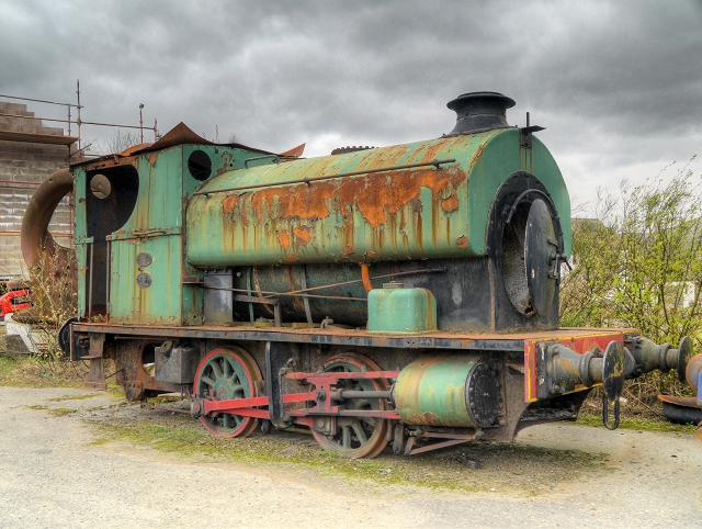
The Lakeland Mines and Quarries Trust negotiated a lease in 1992 and, working with volunteers, restored buildings, cleared old plant foundations and landscaped the site to open the Threlkeld Quarry and Mining Museum, which now displays vintage excavators, cranes and locomotives, runs a narrow-gauge railway and an underground simulated mine tour, and holds a geological and mining museum covering the district's granite, lead, zinc, tungsten, graphite, barytes and fluorite workings. The mines on the fell above the museum are a separate matter: a visit reported in August 2022 found the Gategill levels open and followable, with a shaft coming down from above into the Low Level and worked-out ground beyond a junction that eventually fizzles out, while at Woodend the High (Smithy) Level was blocked and the Low (Horse) Level, though accessible, carried heavily polluted water that the visitor deliberately left undisturbed.
The quarry itself, with restored buildings, cleared plant foundations and the museum’s collection of excavators, cranes and locomotives on the floor of it, and a narrow-gauge railway. On Blencathra above, the Gategill levels survive with an opencut along the vein, a length of rail still projecting at the foot of it, the top of the shaft that connects the Low Level to the workings above, the line of the tramway to the Middle Level, the remains of an incline and a dam. Woodend’s High or Smithy Level is blocked; its Low or Horse Level is open and carries one of the most polluting mine-water discharges in the country.
Related mines
- Bramcrag Quarry — Bramcrag is one of the seven quarries working the same Threlkeld microgranite around Threlkeld Knotts, and was reached by an extension of the Threlkeld quarry railway.
Nearby mines
- Bramcrag Quarry — 1.3 miles (2.0 km) SE
- Thornthwaite Mine — 4.9 miles (7.9 km) W
- Carrock Fell Mine — 5.1 miles (8.2 km) N
- Greenside Mine — 5.2 miles (8.3 km) SE
- Brandelhow Mine — 5.6 miles (9.0 km) SW
Straight-line distance, within 9 miles (15 km). Show on the map.
What's uncertain
Points where sources disagree or the record could not be settled; both accounts are kept. All open questions in the archive.
- A March 2020 permission-visit report describes a steam-powered Ruston Bucyrus excavator surviving in deteriorating condition among the museum's collection, alongside restoration work by Lakeland Mines and Quarries Trust volunteers since 1992 to repair buildings and clear old plant foundations. (uncertain) 3
Recorded claims
Individual factual claims, each attached to the source(s) that support it below. Where sources disagree, both are kept.
- Threlkeld's granite output grew from a few hundred tons a year at opening in the 1870s to 80,000 tons by 1894, as demand grew from railway ballast, roadstone and the Manchester Corporation Waterworks' Thirlmere scheme. 1
- Threlkeld closed in 1937 after its 1936 merger with the Cumberland Granite Company of Embleton, being judged the less profitable of the two sites, before reopening in 1949 for its final 33 years of operation. 1
- Nearby Gategill and Woodend mines, together known as Threlkeld mine, were worked for lead — and later also zinc and barytes — between 1661 and 1928. 2
- A March 2020 permission-visit report describes a steam-powered Ruston Bucyrus excavator surviving in deteriorating condition among the museum's collection, alongside restoration work by Lakeland Mines and Quarries Trust volunteers since 1992 to repair buildings and clear old plant foundations. (uncertain) 3
- The Threlkeld microgranite is a laccolithic intrusion cropping out on Low Rigg, Threlkeld Knotts, Bramcrag and around White Pike, intruding both the Skiddaw Group and the lowest part of the Borrowdale Volcanic Group; it is composed of plagioclase, subordinate alkali feldspar, garnet and quartz phenocrysts in a groundmass of quartz, plagioclase, chlorite and iron oxide, and has been dated by rubidium–strontium isochron to 438 ± 6 million years, recalculated as 445 ± 15. 4
- Threlkeld is one of the major concentrations of lead–zinc mineralisation in the Keswick district. Such veins carry galena and sphalerite with minor chalcopyrite and silver as an important impurity, in a gangue of quartz, baryte, calcite and dolomite; they are assigned an Early Carboniferous age and attributed to hydrothermal activity generated by the Lake District batholith. 4
- Gategill, the older and higher, was worked mainly for lead, and Woodend, the lower, for both lead and zinc as well as some barytes; the two together are usually called the Threlkeld mine and were worked between 1661 and 1928. 5
- A visit in August 2022 found the Gategill levels open, with a shaft coming down from above into the Low Level, while Woodend’s High (Smithy) Level was blocked and its Low (Horse) Level, though accessible, carried one of the most polluting mine-water discharges in the country. 5
Photographs & further reading
A permission-visit report covering the museum's crushing plant, railway infrastructure and vintage excavator collection.
View sourceThe survey account of the ground the quarry and the mines both sit in: the Threlkeld microgranite’s form, composition and age, and the district’s lead–zinc vein mineralisation.
View sourceAn underground visit to the Gategill levels, with the state of the Woodend levels and the surviving tramway, incline and dam on the fellside.
View sourceSources
- (secondary) History — Threlkeld Quarry and Mining Museum
- (secondary) Threlkeld Quarry and Mining Museum — Wikipedia
- (observational) Threlkeld Mining Museum, Cumbria — March 2020 (permission visit) — 28DaysLater
- (primary) Geology of the Keswick district: sheet description, 1:50 000 sheet 29 — British Geological Survey
- (observational) Threlkeld lead and zinc mine, Cumbria — August 2022 — 28DaysLater
- (primary) BGS mine plans catalogue: THRELKELD LEAD MINE — British Geological Survey
Record created: 20 August 2026 · Last researched: 6 September 2026