 MineArchive
Tankersley Colliery
| Location | Westwood, near High Green, between Sheffield and Barnsley, South Yorkshire — 53.4862, -1.4883 (approximate) |
|---|---|
| Commodity | Coal |
| Type | Coal |
| Worked | By 1867–1927 |
| Maximum depth | Unknown. |
| Operators | Newton, Chambers and Co. Ltd (1867–1947) |
Overview
A Newton, Chambers colliery at Westwood near High Green, worked from the 1860s until 1927 and then kept as a pumping shaft for Thorncliffe Colliery.
History
Tankersley Colliery lay at Westwood, near High Green, five miles south of Barnsley, and belonged to Newton, Chambers and Co., the ironmasters of Thorncliffe. It was at work by 1867, and the Northern Mine Research Society records a sinking there in 1873. The colliery stood north of Westwood station on the South Yorkshire Railway's Blackburn Valley line, to which it was joined by an industrial spur. Two colliers, Thomas Dickinson and William Shepherd, were killed by an explosion of gas on 25 November 1871.
The pit raised coking and household coal, and gas coal from 1905. Employment grew from 254 in 1894 to 462 in 1900 and 728 in 1910, and stood at 693 in 1923. It worked the Fenton seam in 1910, and the Fenton, Parkgate, Silkstone and Whinmoor seams by 1915.
Coal working ended in 1927. From 1928 the shaft was kept as a pumping station, still in use in 1947; in 1946 it was one of the three pumping shafts of Newton, Chambers' Thorncliffe Colliery, with Barley Hall and Skiers Spring. Part of the colliery's spoil heaps survives on the Barnsley boundary above High Green.
Geology
Coal Measures of the South Yorkshire coalfield. The Fenton seam was worked in 1910, and the Fenton, Parkgate, Silkstone and Whinmoor seams in 1915.
Workings
A shaft colliery north of Westwood station, linked to the Blackburn Valley line by an industrial spur. After coal working ended in 1927 the shaft was kept as a pumping station, and in 1946 it was one of the three pumping shafts serving Thorncliffe Colliery.
Closure
Coal production ended in 1927. The shaft was kept as a pumping station from 1928 and was still pumping in 1947.
What remains
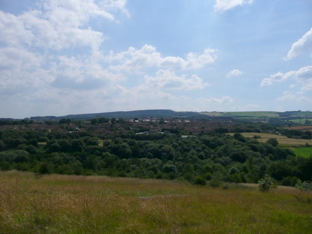
A 2008 photograph from the Barnsley Boundary Walk shows the highest remaining point of the former colliery spoil heaps, looking over High Green.
Part of the colliery spoil heaps (2008).
Redevelopment
Unknown.
Related mines
- Rockingham Colliery — Both Newton, Chambers and Co. collieries on the Thorncliffe company's coalfield south of Barnsley.
- Thorncliffe Colliery — Both Newton, Chambers pits; after coal working ended Tankersley's shaft was one of the three pumping shafts of Thorncliffe Colliery (1946).
Nearby mines
- Wharncliffe Silkstone Colliery — 0.6 miles (0.9 km) NW
- Thorncliffe Colliery — 1.1 miles (1.7 km) SE
- Rockingham Colliery — 1.4 miles (2.3 km) NE
- Hoyland Silkstone Colliery — 2.4 miles (3.8 km) NE
- Wharncliffe Wood Ganister Mines — 2.6 miles (4.2 km) S
Straight-line distance, within 9 miles (15 km). Show on the map.
Recorded claims
Individual factual claims, each attached to the source(s) that support it below. Where sources disagree, both are kept.
- Tankersley Colliery at Thorncliffe is listed from 1867 to 1927, sunk in 1873, and used as a pumping station in 1928 and 1947. 1
- The colliery employed 254 in 1894, 728 in 1910 and 693 in 1923. 2
- The Fenton seam was worked in 1910, and the Fenton, Parkgate, Silkstone and Whinmoor in 1915. 2
- Tankersley colliery lay north of Westwood station and was connected to the Blackburn Valley line by an industrial spur. 3
- In 1946 Thorncliffe Colliery had three pumping shafts, at Tankersley, Barley Hall and Skiers Spring. 4
- Thomas Dickinson (31) and William Shepherd (21), colliers, were killed by an explosion of gas on 25 November 1871. 2
- A plan of the Whinmoor seam at Tankersley Colliery is held in the national abandoned-mine plan catalogue. 5
- A 2008 photograph shows the highest remaining point of the former Tankersley Colliery spoil heaps. 6
Photographs & further reading
A 2008 photograph from the top of the surviving Tankersley Colliery spoil heaps.
View sourceOwners, output, employment and seams from 1894 to 1923, and the names of those killed at the colliery.
View sourceSources
- (secondary) Coal Mines in Yorkshire 1854 onwards (T) - Northern Mine Research Society — Northern Mine Research Society
- (primary) Durham Mining Museum - Tankersley Colliery (UK) — Durham Mining Museum
- (secondary) Westwood railway station — Wikipedia
- (secondary) Thorncliffe Colliery - Northern Mine Research Society — Northern Mine Research Society
- (primary) BGS mine plans: Tankersley Colliery (Whinmoor seam) — British Geological Survey / Mining Remediation Authority
- (observational) View over High Green (Geograph, Wendy North, 2008) — Geograph
Record created: 1 October 2026 · Last researched: 1 October 2026