 MineArchive
South Tamar Consols
| Location | Cleave, south of Weir Quay, Bere Alston peninsula, Bere Ferrers parish, Devon — 50.4599, -4.2055 (exact) |
|---|---|
| Commodities | Lead, Silver |
| Type | Metal |
| Worked | 1820–1856 |
| Maximum depth | 120 fathoms (219 m) in 1856 |
Overview
A silver-lead mine on the Bere Alston peninsula that followed its lode under the River Tamar, paid £20,250 in dividends in three years, and was destroyed in five minutes one Sunday evening in 1856 when the river burst into the workings.
History
The ground at Cleave, south of Weir Quay, was the 'Mouth of the Silver Mines' on a map of 1737, part of the old Bere Ferrers silver mines. The Beer Ferrers mine returned 76,000 ounces of silver and 1,400 tons of lead ore in the seven years to 1795, and in 1820 the Birch and Cleave lode was merged with South Hooe as South Tamar Consols. In 1846 the South Tamar United Mining Company took a 21-year lease from Earl Mount Edgcumbe, with ground under the Tamar held from the Duchy, and in 1847 put a 60-inch engine on Cowie's Shaft. The South Tamar Consols Mining Company formed in July 1848 and sold its first ore a year later.
In 1854 and 1855 the mine reached its peak, averaging about 1,400 tons of ore, 840 tons of lead and 60,689 ounces of silver a year; in 1854 it employed 301 people and made £20,125 profit, and its dividends in 1852-54 came to £20,250. Its workings ran 120 fathoms deep, the shallowest level only 30 fathoms under the river bed. One Sunday evening in 1856 a soft 'slide' in the river bed gave way and the Tamar poured in, filling the mine within five minutes; the rush of air blew the hatches off the shafts. Bere Alston was soon almost deserted, with miners leaving for Chile, New Zealand and America. Some £30,000 of machinery was lost, the surface engines were auctioned that December, and the mine was never reworked; from 1849 to 1860 it had raised 7,140 tons of lead ore and from 1852 to 1860 262,470 ounces of silver.
Geology
The central north-south silver-lead lode of the Bere peninsula, rich in silver near the surface, with fluorspar.
Workings
Cowie's Shaft on the river bank, 90 fathoms by 1846, with a 60-inch pumping engine; levels ran under the Tamar, the shallowest 30 fathoms below the river bed; surface engines for winding, pumping, stamping and crushing.
Closure
The mine flooded from the River Tamar in 1856 and was abandoned; its machinery was auctioned and it was never reworked.
What remains
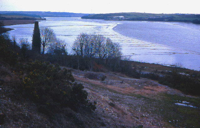
Spoil heaps, terraces and tailings ponds survive on the hillside above the river; two chimneys were shown on the 1883 Ordnance Survey map.
A chimney, spoil heaps, terraces and the sites of tailings ponds.
Redevelopment
Unknown.
Related mines
- Bere Alston Silver-Lead Mines — The mine worked the same lode as the medieval royal silver mines of Bere Ferrers.
- South Hooe Mine — In 1820 the Birch and Cleave lode was merged with South Hooe to form South Tamar Consols.
Nearby mines
- South Hooe Mine — 0.7 miles (1.1 km) NW
- Bere Alston Silver-Lead Mines — 1.8 miles (2.9 km) N
- Okeltor Mine — 2.8 miles (4.5 km) N, Cornwall
- Gawton Mine — 2.9 miles (4.6 km) N
- Danescombe Mine — 3.0 miles (4.9 km) N, Cornwall
Straight-line distance, within 9 miles (15 km). Show on the map.
Recorded claims
Individual factual claims, each attached to the source(s) that support it below. Where sources disagree, both are kept.
- South Tamar Consols paid dividends of £20,250, or £2 5s. a share, in 1852-1854. 1
- In 1854-55 the mine averaged about 1,400 tons of ore, 840 tons of lead and 60,689 ounces of silver a year, and in 1854 employed 301 people. 2
- In 1856 the River Tamar broke through a soft 'slide' in its bed and flooded the 120-fathom workings within five minutes. 2
- After the flood Bere Alston was almost deserted, with miners leaving for Chile, New Zealand and America; the machinery lost was put at £30,000. 2
- From 1849 to 1860 the mine raised 7,140 tons of lead ore, and from 1852 to 1860 262,470 ounces of silver. 2
- In 1856 the machinery on the mine was said to be worth £15,000. 1,2
Sources
- (secondary) 1856 Mines in Devon and Cornwall — Grace's Guide
- (secondary) Buck, C. South Tamar Consols, Bere Alston, Devon: Archaeological Assessment (Report 2010R042, Historic Environment Projects, Cornwall Council) — Archaeology Data Service
Record created: 19 October 2026 · Last researched: 19 October 2026