 MineArchive
Bere Alston Silver-Lead Mines
| Also known as | Bere Ferrers Silver Mines |
|---|---|
| Location | Bere Alston, on the Tamar, Devon — 50.4860, -4.2000 (approximate) |
| Commodities | Silver, Lead |
| Type | Metal |
| Worked | 1292–mid-16th century |
| Operators | Queen Isabella, John of Gaunt |
Overview
The royal silver mines around Bere Alston and Bere Ferrers, on the west bank of the Tamar, were an industrial-scale medieval operation unmatched anywhere else in England — and not equalled in continental Europe until at least the 17th century.
History
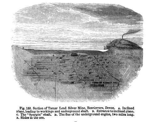
Silver mining at Bere Ferrers began in 1292 under the direct management of Crown officers, continuing under royal control until 1349, after which the mines were operated by Crown lessees -- generally leased collectively alongside the Crown's other silver-mining interest at Combe Martin. The scale of the operation was unprecedented for its time and has no parallel in the late medieval English economy: the mines provided work for up to 400 men on wages and piecework, many of them immigrants and some pressed into service and moved to Devon from other English mining fields such as Derbyshire and the Lake District. In 1296-97 alone, fifteen per cent of all the silver reaching the London mint came from Bere Ferrers, silver that helped fund Edward I's wars. The mines' most remarkable surviving engineering achievement is the Lumburn leat, built in the 15th century and running some 16 kilometres from west of Tavistock, near Millhill, into the mines south-west of Bere Alston, including rock-cut tunnels and cuttings on the western side of the Tavy to power pumping equipment. The establishment of the borough of Bere Alston followed directly from the mines, with a market operating from 1295 to supply the growing workforce. The mines were finally abandoned by the mid-16th century. After the Black Death, the Crown increasingly leased the mines to nobles and merchants rather than working them directly; recorded lessees included Queen Isabella and John of Gaunt, and the mines were also the subject of a dispute involving Sir Roger Champernowne.
Geology
Silver-bearing lead of the Tamar valley; the veins worked are not named on the record.
Workings
The 15th-century Lumburn leat carried water some 16 kilometres to power pumping equipment at the mines, including rock-cut tunnels and cuttings on the western side of the River Tavy.
Closure
The mines were finally abandoned by the mid-16th century.
What remains
Medieval mine earthworks survive amongst the near-continuous linear earthworks running from Lockridge Hill south to Cleave Wood, though later 18th- and 19th-century mining debris overlies and partly obscures the medieval workings in places.
Nearby mines
- Okeltor Mine — 1.0 miles (1.6 km) N, Cornwall
- Gawton Mine — 1.2 miles (1.9 km) NE
- George and Charlotte Copper Mine — 1.4 miles (2.3 km) N
- South Hooe Mine — 1.5 miles (2.4 km) SW
- Danescombe Mine — 1.6 miles (2.5 km) NW, Cornwall
Straight-line distance, within 9 miles (15 km). Show on the map.
Recorded claims
Individual factual claims, each attached to the source(s) that support it below. Where sources disagree, both are kept.
- In 1296–97 alone, fifteen per cent of all the silver reaching the London mint came from Bere Ferrers. 1
- Over 300 men were employed on wages and piecework at Bere Ferrers, many pressed into service and moved to Devon from other English mining fields such as Derbyshire and the Lake District — a scale of operation not matched in continental Europe until at least the 17th century. 1
- A 15th-century leat carried water some 16 kilometres from west of Tavistock into the mines south-west of Bere Alston, including rock-cut tunnels and cuttings on the western side of the River Tavy. 1
- The mines employed up to 400 men on wages and piecework, many of them immigrants and some pressed into service and moved to Devon from other English mining fields such as Derbyshire and the Lake District. 1,2
- After 1349 the Bere Ferrers mines were operated by Crown lessees, generally leased collectively alongside the Crown's other silver-mining interest at Combe Martin -- also documented on this archive. 2
- The Bere Ferrers mines were finally abandoned by the mid-16th century. 2
- After the Black Death, the Crown increasingly leased the mines to nobles and merchants rather than working them directly; recorded lessees included Queen Isabella and John of Gaunt, and the mines were also the subject of a dispute involving Sir Roger Champernowne. 1,2
Photographs & further reading
The full academic paper on the mines' Crown-managed workforce, capital and landscape impact.
View sourceSources
- (primary) Medieval silver mining, Bere Ferrers — University of Exeter
- (primary) The Crown silver mines in Devon: capital, labour and landscape in the late medieval period — Historical Metallurgy 44(2), 2010 (Peter Claughton and Chris Smart)
Record created: 20 August 2026 · Last researched: 31 August 2026