 MineArchive
Silverdale Colliery
| Also known as | Kent's Lane Colliery |
|---|---|
| Location | Kents Lane, Silverdale, west of Newcastle-under-Lyme, Staffordshire — 53.0159, -2.2675 (exact) |
| Commodities | Coal, Ironstone |
| Type | Coal |
| Worked | 1830–December 1998 |
| Maximum depth | Unknown. The 1970s reconstruction was worked through surface drifts of about 4,000 yards. |
| Operators | National Coal Board (1947–1994) |
Overview
The last deep mine in North Staffordshire, sunk in 1830 to feed the Silverdale ironworks and closed in December 1998. It raised ironstone alongside its coal in the early years, was rebuilt after nationalisation around long surface drifts driven towards Keele, and at its height was winning over a million tonnes a year. Its site is now Silverdale Country Park; one of its spoil heaps caught fire in 1996 and is still burning.
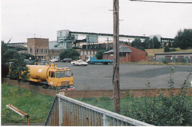
History
Coal was worked around Silverdale as long ago as the thirteenth century, but the colliery proper — known locally as Kent’s Lane — dates from 1830, when the first shafts were sunk to supply the Silverdale ironworks. Ironstone was raised alongside the coal, and the main user of both was the forge next door: this was a colliery built to feed an ironworks rather than a market. It was the main employer in the village for well over a hundred years. After nationalisation the pit was rebuilt rather than run down. Staffordshire Past Track dates the mechanisation programme to 1950 and puts the investment at £20 million, with a new mine, two surface drifts of 4,000 yards each driven to win 50 million tonnes in the Keele and Hanchurch area, and a new coal preparation plant. The Wikipedia account places the complete rebuilding in the 1970s and counts three new drifts. Either way the effect was the same: production rose and the pit was winning over a million tonnes a year. Coal left by rail from a rapid loader beside the old Silverdale station, on the North Staffordshire Railway’s Newcastle to Market Drayton line. It was still working when every other deep mine in North Staffordshire had gone. The last coal was drawn in December 1998.
Geology
The North Staffordshire Coalfield west of Newcastle-under-Lyme, where coal and ironstone lie together — which is why the colliery and the ironworks were built as one enterprise. The BGS catalogue of abandoned plans records Silverdale No. 17 Red Mine and Silverdale Red Shagg Ironstone alongside its coal plans, the ironstone being worked as a distinct product rather than a by-product. The reserves that kept the pit alive after nationalisation lay east and south, in the Keele and Hanchurch ground, and were reached by driving long drifts from the surface rather than by deepening the old shafts.
Workings
Shafts from 1830, and from the post-war reconstruction a set of surface drifts about 4,000 yards long driven towards the Keele and Hanchurch reserves, with a new coal preparation plant on the surface. Sources differ on whether there were two drifts, driven from 1950, or three, driven in the 1970s. Coal was loaded to rail at a rapid loader next to the former Silverdale station.
Closure
Silverdale closed in December 1998, the last deep mine in North Staffordshire to do so, having outlasted Holditch by nearly a decade and taken some of its men. Two years before it closed, in 1996, one of its spoil heaps on Hollywood Road between Silverdale and Keele caught fire, and it is still burning.
What remains
Silverdale Country Park, 83 hectares, occupies the former colliery — a restoration funded through the National Coalfields Programme and now held by the Land Trust. It has two parts: the Waste Farm Plateau, open grassland on several levels built from colliery spoil, with long views from its highest point; and the Void, a steeply sloping bowl with the Southern Pool at its foot, designated a Site of Biological Importance in 2015. Ibstock work a large clay quarry next to the former colliery. The burning spoil heap on Hollywood Road remains: the fire is mostly underground, but heat and smoke have reached the surface and set fire to parts of the wood the road is named for.
Nothing of the colliery buildings survives on the site, which has been landscaped into Silverdale Country Park; the Waste Farm Plateau is made of its spoil and the Void is the shape the workings left.
Related mines
- Holditch Colliery — When Holditch closed at the end of the 1980s many of its miners transferred here, to the pit that became the last deep mine working in North Staffordshire; Silverdale outlasted it by nearly a decade, closing on Christmas Eve 1998.
Nearby mines
- Apedale Colliery — 0.7 miles (1.1 km) N
- Holditch Colliery — 1.3 miles (2.1 km) NE
- Leycett Colliery — 1.8 miles (2.9 km) W
- Minnie Pit — 2.3 miles (3.7 km) NW
- Glasshouse Colliery — 2.3 miles (3.8 km) N
Straight-line distance, within 9 miles (15 km). Show on the map.
Disasters & major incidents
-
Silverdale Colliery fall of coal, 1857
4 September 1857 · Collapse / Roof Fall · 2 fatalities
J. Lunt and S. Plat were killed together by a fall of coals at Silverdale Colliery, North Staffordshire, on 4 September 1857. -
Silverdale Colliery Sheriff Pit explosion, 1870
7 July 1870 · Explosion · 19 fatalities
On the afternoon of 7 July 1870 firedamp exploded in the Eight Feet workings of the Sheriff Pit at Silverdale, North Staffordshire, killing nineteen men and boys; one man survived from the district. -
Silverdale Colliery explosion, 1872
1872 · Explosion · 8 fatalities
At 8 a.m. on 21 December 1872 gas fired in the Bullhurst seam of Stanier and Company's Silverdale Colliery, Staffordshire, killing all eight men near it; the shaft belched stones and coal. The inspector blamed the management for reopening workings he had had bricked up months before, and the jury could not agree a verdict. -
Silverdale Colliery Sheriff Pit explosion, 1876
1876 · Explosion · 5 fatalities
At about 3 p.m. on 6 April 1876 a shot fired in the Seven Feet seam of Stanier's Sheriff Pit at Silverdale ignited a little gas and a quantity of coal dust in the dry workings, killing five colliers, among them the fireman Thomas Wright. -
Silverdale Colliery explosion, 1878
7 June 1878 · Explosion · 3 fatalities
A shot fired in the Eight Feet seam of Silverdale's No. 6 pit on 7 June 1878 brought an explosion that killed a man of 40 and two boys of 16 and 14.
What's uncertain
Points where sources disagree or the record could not be settled; both accounts are kept. All open questions in the archive.
- A mechanisation programme began in 1950 with £20 million invested: a new mine and two drifts from the surface, each of 4,000 yards, to extract 50 million tonnes in the Keele–Hanchurch area, and a new coal preparation plant. (disputed) 2
- The colliery was completely rebuilt during the 1970s when three new drifts were sunk to exploit new reserves in the Keele area, after which production increased and the pit mined over one million tonnes annually. (disputed) 1
Recorded claims
Individual factual claims, each attached to the source(s) that support it below. Where sources disagree, both are kept.
- Silverdale opened in 1830 to provide coal for the Silverdale ironworks. The first shafts were sunk in the 1830s and the colliery initially mined ironstone as well as coal, the main user of both being the nearby Silverdale Forge. 1,2
- A mechanisation programme began in 1950 with £20 million invested: a new mine and two drifts from the surface, each of 4,000 yards, to extract 50 million tonnes in the Keele–Hanchurch area, and a new coal preparation plant. (disputed) 2
- The colliery was completely rebuilt during the 1970s when three new drifts were sunk to exploit new reserves in the Keele area, after which production increased and the pit mined over one million tonnes annually. (disputed) 1
- Silverdale was the last deep mine operating in North Staffordshire; the final coal was worked in December 1998. 1,2,3
- The BGS catalogue of abandoned mine plans holds records titled "SILVERDALE NO.17 RED MINE" and "SILVERDALE RED SHAGG IRONSTONE" alongside the colliery’s coal plans. 4
- One of the colliery spoil heaps, on Hollywood Road between Silverdale and Keele, caught fire in 1996 — two years before the site closed — and has continued to burn for more than two decades. The fire is primarily underground, but heat and smoke have at times reached the surface and set fire to parts of Holly Wood. 1
- Silverdale Country Park, 83 hectares, was created on the former colliery as part of a restoration project funded through the National Coalfields Programme and is a park of the Land Trust. The Waste Farm Plateau was built from colliery spoil; the Void, a steeply sloping bowl with the Southern Pool at its base, was designated a Site of Biological Importance in 2015. 1
- Located at about 53.016 N, 2.268 W. 1
Photographs & further reading
The county archive’s entry: the 1830 opening to serve the ironworks, the 1950 mechanisation programme and its £20 million, the two 4,000-yard drifts towards Keele, and the December 1998 closure.
View sourceThe village article’s colliery section: the ironstone and the forge, the 1970s rebuilding and million-tonne output, the spoil heap that has burned since 1996, and the country park that now covers the site.
View sourceSources
- (secondary) Silverdale, Staffordshire — Silverdale Colliery — Wikipedia
- (secondary) Silverdale Colliery — Staffordshire Past Track
- (secondary) Main Collieries in North Staffordshire after 1870 — Staffordshire Past Track
- (primary) BGS mine plans catalogue: Silverdale No. 17 Red Mine and Silverdale Red Shagg Ironstone — British Geological Survey
Record created: 7 September 2026 · Last researched: 7 September 2026