 MineArchive
Holditch Colliery
| Also known as | Brymbo Colliery, Chesterton |
|---|---|
| Location | Chesterton, two miles north-west of Newcastle-under-Lyme, Staffordshire — 53.0308, -2.2477 (exact) |
| Commodities | Coal, Ironstone |
| Type | Coal |
| Worked | 1912–1989 or 1990 |
| Maximum depth | Two shafts, each about 2,000 feet deep |
| Operators | National Coal Board (1947–1990) |
Overview
A North Staffordshire colliery at Chesterton, known locally as Brymbo, sunk in 1912 and worked until the end of the 1980s. Its two shafts went down about 2,000 feet to the Great Row and Four Feet seams, reached through the Apedale fault by long stone drifts; it employed 1,500 people, raised ironstone as well as coal, and was reputed the most gassy colliery in Britain. On 2 July 1937 a fire at the coal face and the explosions that followed killed thirty men — among them two of His Majesty’s Inspectors of Mines, the managing director, and four of the Hanley Rescue Brigade (see Disasters, below).
History
The ground has been mined a long time — archaeologists believe coal was worked in the Apedale area as far back as Roman times — but the colliery itself dates from 1912, when the first of its two shafts was sunk; the second followed in 1916. Formerly the main employer in Chesterton, it employed 1,500 men and raised ironstone as well as coal. In 1947 output reached 400,000 tonnes. On 2 July 1937 a fire broke out at a coal-cutting machine on the Four Feet face and a series of explosions followed, killing thirty men; the inspector who investigated found that a change of plan made to save the coal seam had put an unnecessarily large number of men in imminent peril (see Disasters, below). In many ways it stayed an old-fashioned pit — steam power was in use in some form until 1980 — while being modernised after nationalisation with some of the most modern machinery available. Its gassiness became an asset: from July 1976 the colliery supplied 1.25 million therms of methane a year to local brickworks, the equivalent of 4,000 tons of coal, enough to fire half a million bricks a week. Despite heavy investment in the 1960s and 1970s, and while still raising over 500,000 tonnes a year, the colliery closed at the end of the 1980s, three years after the year-long miners’ strike. Many of its men transferred to Silverdale, five miles south, which itself closed on Christmas Eve 1998 as the last deep mine in North Staffordshire.
Geology
The North Staffordshire Coalfield, cut by the Apedale fault — a downthrow estimated at 700 yards, which is what governed the whole layout of the mine. The colliery worked the Great Row and the Four Feet seams, reached from the shafts by two parallel stone drifts driven south-westwards to pass through the fault and pick up the Four Feet on its downthrown side. The Four Feet coal was 4 feet 9 inches thick, with a fireclay floor and a soft blue shale roof. The colliery was believed to be the most gassy in Britain, and the firedamp that made it dangerous was, forty years later, piped out and sold.
Workings
Two shafts about 2,000 feet deep to the stone drifts serving the two seams. The intake road ran level for 125 yards from the downcast shaft, then continued straight for half a mile at 1 in 11 and through the Apedale fault. When the Four Feet turned out to lie lower than expected the gradient was steepened to 1 in 4 and then to 1 in 3 until the seam was reached — a single straight road 1,390 yards long from shaft to coal face, opening into a double-unit face 230 yards long. Working was by machine: the coal was undercut six feet by a coal-cutting machine, blasted down and loaded onto a face belt conveyor that fed the main gate belt and so the haulage road. The Four Feet carried eight firemen across three shifts, an overman on each, and between sixty and seventy miners a shift, producing about 350 tons a day. Modernisation after 1947 brought in some of the most modern machinery of the period, although steam power survived on the site in some form until 1980.
Closure
The colliery closed at the end of the 1980s, still raising over 500,000 tonnes a year, three years after the 1984–85 strike and despite heavy investment in the previous two decades. Sources differ on the year: Staffordshire Past Track gives 1912–1989, the Wikipedia account 1990. Many of the men went to Silverdale.
What remains
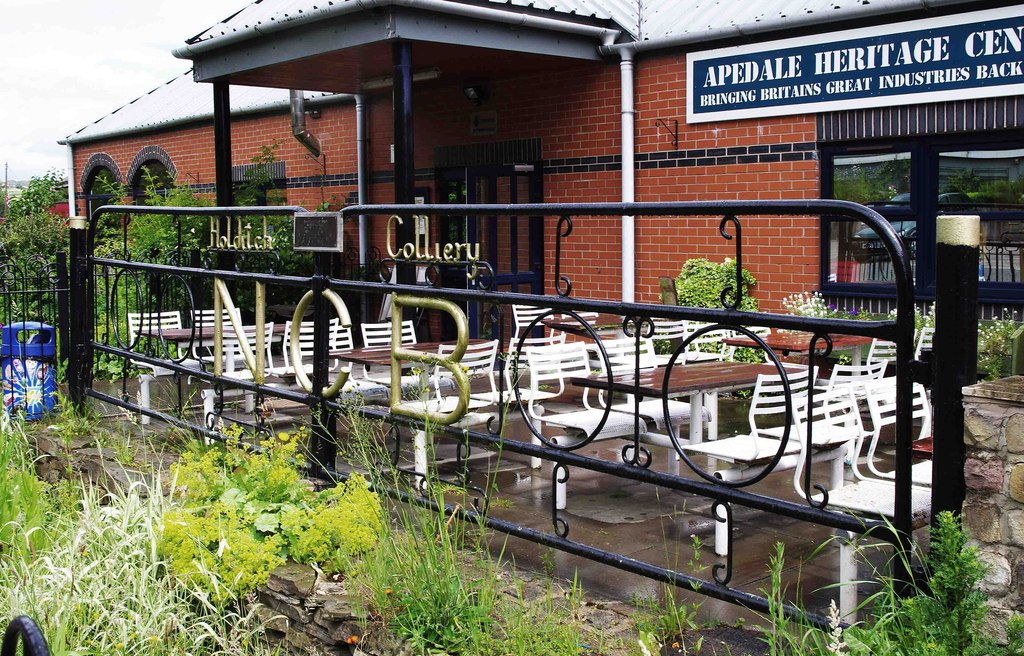
The colliery site is now a large business park. The colliery gates survive, re-erected at the Apedale Heritage Centre in Apedale Community Country Park nearby, and the memorial to the thirty men killed in 1937 stands there.
The National Coal Board colliery gates, now at the Apedale Heritage Centre, and the 1937 disaster memorial there. Nothing of the pit itself survives on its own site.
Related mines
- Silverdale Colliery — When Holditch closed at the end of the 1980s many of its miners transferred here, to the pit that became the last deep mine working in North Staffordshire; Silverdale outlasted it by nearly a decade, closing on Christmas Eve 1998.
Nearby mines
- Apedale Colliery — 0.8 miles (1.3 km) SW
- Silverdale Colliery — 1.3 miles (2.1 km) SW
- Glasshouse Colliery — 1.4 miles (2.2 km) N
- Wolstanton Colliery — 1.6 miles (2.6 km) E
- Diglake Colliery — 2.2 miles (3.5 km) NW
Straight-line distance, within 9 miles (15 km). Show on the map.
Disasters & major incidents
-
Holditch Colliery disaster, 1937
2 July 1937 · Explosion · 30 fatalities
A fire that began at a coal-cutting machine on the Four Feet face at Holditch Colliery, Chesterton, at about a quarter to six on the morning of 2 July 1937, and the eight explosions that followed it. Thirty men died and eight were injured. Almost all of them were killed by the last explosion, more than four hours after the fire started, while building stoppings in a position chosen against the manager’s advice in order to save the coal seam. The dead included two of His Majesty’s Inspectors of Mines, the colliery’s joint managing director, the under-manager and four members of the Hanley Rescue Brigade.
What's uncertain
Points where sources disagree or the record could not be settled; both accounts are kept. All open questions in the archive.
- Staffordshire Past Track dates the colliery 1912–1989; the Wikipedia account says it closed in 1990, three years after the end of the year-long miners’ strike, with many of its miners transferring to Silverdale Colliery. (disputed) 1,2
Recorded claims
Individual factual claims, each attached to the source(s) that support it below. Where sources disagree, both are kept.
- The colliery opened in 1912 and consisted of two shafts approximately 2,000 feet deep, sunk in 1912 and 1916, working the Great Row and Four Feet seams. 1,2
- Formerly the main employer in Chesterton, the colliery employed 1,500 men and mined ironstone in addition to coal; output reached 400,000 tonnes in 1947 and was over 500,000 tonnes a year just before closure. 1
- The colliery was reputed to be the most gassy in Britain. From July 1976 it supplied 1.25 million therms of gas a year to local brickworks — the equivalent of 4,000 tons of coal — firing 500,000 bricks a week. 1,2
- Two parallel stone drifts were driven from the shafts, dipping south-west to tap the Four Feet seam through the Apedale fault, a downthrow estimated at 700 yards. The intake road ran level for 125 yards from the downcast shaft, then half a mile at 1 in 11; when the seam proved lower than anticipated the gradient was increased to 1 in 4 and then 1 in 3, giving a straight road 1,390 yards long from shaft to face. 3
- The Four Feet coal was 4 feet 9 inches thick with a fireclay floor and soft blue shale roof, undercut six feet by machine and then blasted down onto a face belt conveyor. The double-unit face was 230 yards long, worked by between sixty and seventy miners a shift producing about 350 tons a day. 3
- Staffordshire Past Track dates the colliery 1912–1989; the Wikipedia account says it closed in 1990, three years after the end of the year-long miners’ strike, with many of its miners transferring to Silverdale Colliery. (disputed) 1,2
- Between 1949 and 1967 eleven further deaths were recorded at the colliery, most of them due to roof falls. 1
- The site of Holditch Colliery is now a large business park. A memorial to the victims of the 1937 disaster stands at the Apedale Heritage Centre. 1
Photographs & further reading
The county archive’s short entry: dates, the two 2,000-foot shafts, the 1937 explosion, post-nationalisation modernisation, and the methane sold to local brickworks from 1976.
View sourceThe fullest narrative of the disaster, and with it the clearest description of how the mine was laid out: the stone drifts through the Apedale fault, the gradients, the face and the shift pattern.
View sourceSources
- (secondary) Holditch Colliery disaster — Wikipedia
- (secondary) Holditch Colliery — Staffordshire Past Track
- (secondary) Holditch Colliery Explosion 1937 — John Lumsdon, healeyhero.co.uk
- (primary) BGS mine plans catalogue: Holditch — British Geological Survey
- (primary) Holditch Colliery Disaster — HC Deb 5 July 1937 vol 326 cc33-6 — Hansard, House of Commons
Record created: 7 September 2026 · Last researched: 7 September 2026