 MineArchive
Ryhope Colliery
| Location | Ryhope, Sunderland, Tyne and Wear — 54.8747, -1.3781 (approximate) |
|---|---|
| Commodity | Coal |
| Type | Coal |
| Worked | 1857 (sinking)–25 November 1966 |
| Maximum depth | 1,630 feet at the shaft; 1,975 feet in a staple below the Hutton Seam |
| Operators | Ryhope Coal Company Limited (?–1946), Marquess of Londonderry, National Coal Board (1947–1966) |
Overview
A deep Durham coalfield colliery at Ryhope, south of Sunderland, which drew coal from the Hutton and Maudlin seams from 1860 until it closed on 25 November 1966, and employed more than 2,600 men at its peak.
History
Ryhope Colliery stood 2½ miles south of Sunderland on the Durham coast. Boring was under way in 1854 to prove the thickness of the Magnesian Limestone that lies over the coal measures here, and the North and West Pits were sunk from 1857; William Liddell was killed on 5 December 1857 when a sinking cradle jerked and threw him into 18 feet of water at the shaft bottom. The shafts went down to the Hutton Seam and coal was first drawn in February 1860. Lord Londonderry owned the colliery in the 1860s; it later passed to the Ryhope Coal Company Limited, which ran it until nationalisation in 1947, when the National Coal Board took over. Air-compressing plant was installed in 1870 to drive underground machinery and coal-cutters.
By 1894 nearly 2,000 men and boys worked at the pit, drawing about 2,200 tons a day from the Maudlin seam, 7 feet thick, at 270 fathoms, with coal from the 4-foot Hutton seam below brought up to the Maudlin level by a drift; a little was made into coke on the site. Employment reached 2,613 in 1910 and 2,623 in 1925, and the pit raised 530,000 tons in 1947. The Harvey, Busty, Five Quarter, Brass Thill and Brockwell seams were also worked over the years, and the Harvey and Busty seams stopped in 1963. The colliery closed on 25 November 1966.
The colliery village grew up beside the pit: pitmen's rows nearly a mile long, chapels, colliery schools for boys, girls and infants, large Co-operative stores and a Miners' Hall of 1880 with a lecture hall seating 800 and a library of over 200 volumes. The Durham Mining Museum's list of those killed at the colliery, which it says is not complete, runs to 295 names.
Geology
The coal lies beneath the Magnesian Limestone, whose thickness a boring proved in 1854 before the shafts were sunk. The Hutton Seam lies 1,630 feet down at the shaft, and a staple put down below it in 1905 proved the Harvey Seam at about 1,810 feet, the Busty at about 1,882 feet and the Brockwell at about 1,961 feet, through a succession of shales ('metal'), sandstones ('post') and seatearths.
Workings
Two pits, North and West, worked the Maudlin and Hutton seams and later the Harvey, Busty, Five Quarter, Brass Thill and Brockwell. Hutton coal was brought up to the Maudlin level by a drift, and coal-cutters were driven by compressed air from 1870. Colliery Engineering carried articles on the pneumatic cleaning of the colliery's coal (1932) and on its electrification (1935).
Closure
The colliery closed on 25 November 1966. In 1965 it still employed 1,263 men, 973 below ground and 290 on the surface, down from 2,184 in 1950.
What remains
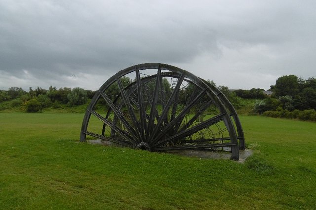
The colliery has been cleared. Memorial winding gear stands on its site, and the site of the miners' union office is a memorial garden.
Memorial winding gear on the colliery site and, on the site of the union office, the Ryhope Colliery Memorial Garden (photographed 2014 and 2016). A bronze pit-pony statue was set up at the Stockton Road entrance to Ryhope in 2009.
Redevelopment
The miners' union office site is now a memorial garden.
Nearby mines
- Silksworth Colliery — 1.4 miles (2.2 km) W
- Seaham Colliery — 2.5 miles (4.0 km) S, County Durham
- Wearmouth Colliery — 2.8 miles (4.5 km) N
- Westoe Colliery — 3.2 miles (5.1 km) NW, County Durham
- Vane Tempest Colliery — 3.4 miles (5.5 km) SE, County Durham
Straight-line distance, within 9 miles (15 km). Show on the map.
Culture
- Ryhope Colliery Welfare F.C. (Sports)
Founded in 1892 by the coal miners of Ryhope, the village whose colliery drew its first coal in 1860; the club kept 'Colliery Welfare' in its name after the colliery closed in 1966.
What's uncertain
Points where sources disagree or the record could not be settled; both accounts are kept. All open questions in the archive.
- Wikipedia's account of Ryhope gives 1859 as the year the colliery opened. (disputed) 3
Recorded claims
Individual factual claims, each attached to the source(s) that support it below. Where sources disagree, both are kept.
- The North and West Pits were sunk from 1857 to the Hutton Seam, and coal was first drawn in February 1860. 1,2
- Wikipedia's account of Ryhope gives 1859 as the year the colliery opened. (disputed) 3
- The colliery closed on 25 November 1966. 1,2,3
- Owned by Lord Londonderry in the 1860s, then by the Ryhope Coal Company Limited, and by the National Coal Board from 1947. 1,2
- In 1894 nearly 2,000 men and boys worked at the colliery, drawing about 2,200 tons a day from the 7-foot Maudlin seam at 270 fathoms. 1,2
- Employment stood at 2,613 in 1910 and 2,623 in 1925; output in 1947 was 530,000 tons. 1
- The shaft stood 174 feet above sea level and reached the bottom of the Hutton Seam at 1,630 feet 1 inch. 4
- The Miners' Hall, a brick building of 1880, held a lecture hall for 800 and a library of over 200 volumes. 1,2
- The Coal Authority's abandonment plan for the Harvey seam at Ryhope is dated 30 November 1962. 5
- An air receiver at the colliery exploded in 1883 and was the subject of an official report (C.3690). 1
Photographs & further reading
Photograph of the memorial garden on the site of the miners' union office, with a note on deaths at the colliery.
View sourceOwners, output, employment 1883-1965, seams worked, a description from Whellan's 1894 directory and a list of men killed.
View sourceThe county Historic Environment Record entry for the colliery, with dates, owners and village buildings.
View sourceHistory of the football club founded by Ryhope coal miners in 1892.
View sourceSources
- (primary) Durham Mining Museum - Ryhope Colliery — Durham Mining Museum
- (primary) Ryhope Colliery (HER 6994), Tyne and Wear Historic Environment Record — Tyne and Wear Historic Environment Record (Sitelines)
- (secondary) Ryhope - Wikipedia — Wikipedia
- (primary) Durham Mining Museum - Ryhope Colliery Shaft Details (1905 staple below the Hutton Seam) — Durham Mining Museum
- (primary) BGS / Mining Remediation Authority abandonment plan: RYHOPE (D926, Harvey seam) — British Geological Survey
Record created: 29 September 2026 · Last researched: 29 September 2026