 MineArchive
Red Rock Mine
| Also known as | Graig Goch Mine, Graiggoch Mine, Cwmnewyddion Mine |
|---|---|
| Location | South slope of Cwm Newidion, near Frongoch, Ceredigion — 52.3487, -3.9055 (exact) |
| Commodities | Lead, Zinc |
| Type | Metal |
| Worked | About 1840–1889 |
| Maximum depth | 60 fathoms below the adit (about 110 m) |
| Operators | John Taylor & Sons (1840–1875) — Messrs. Taylor opened the mine about 1840 and worked it for 23 years. |
Red Rock, or Graig Goch, was a lead mine on the south slope of Cwm Newidion, on the Lisburne property near Frongoch. Old hand-worked diggings on the outcrop came first. The recorded mine was opened about 1840 by the Taylors, who drove two adits and sank a shaft 60 fathoms below them, and it was worked on and off until 1889. It returned 3,282 tons of lead ore in 27 years.
Location
Recorded location. The large pin is this mine; the small round markers are the nearest mines on record. Click one for its page. View on full map
History
There was mining here before there were records of it. On the old refuse heaps lie flattish slabs of grit with hollows worn into them, the anvils on which ore was once broken down by hand, and they belong to work done near the outcrop of the lode before the mine proper began.
That was about 1840, when Messrs. Taylor drove two adits westward into the hill. Good ore was found in both, so a shaft was sunk on the lode to 60 fathoms below the adit, and later a second, eastern shaft for a 12-fathom level. The promise of the upper levels did not hold in depth, where the bunches of ore were short and the ground hard. The mine was active from 1840 to 1855 and from 1869 to 1875, and in their 23 years of working the Taylors raised about 2,300 tons.
Various companies followed. From 1877 to 1882 they raised 775 tons, and there was a last spell of work from 1886 to 1889, when a little blende was sold as well. The whole recorded output is 3,282 tons of lead ore, and the best year was 1872, with 243 tons.
Geology
The mine works a main lode and a second lode that joins it to the west. The yield ran from three-quarters of a ton to two tons of ore to the fathom, the best ground lying around the engine shaft. East of the eastern shaft the lode is large but broken up by soft joints.
Geological setting: Veins and Lodes (well documented example)
Workings
Two adits were driven west into the hill: the upper or middle adit, at about 670 feet above sea level, for some 150 fathoms on the main lode, and the deep adit, 15 or 16 fathoms lower and about 150 yards to the east, for some 210 fathoms. The pumping or engine shaft goes 60 fathoms below the adit. A later eastern shaft served a 12-fathom level. Nothing is known of the extent of the workings after 1877.
Closure
The last period of working ran from 1886 to 1889.
What remains
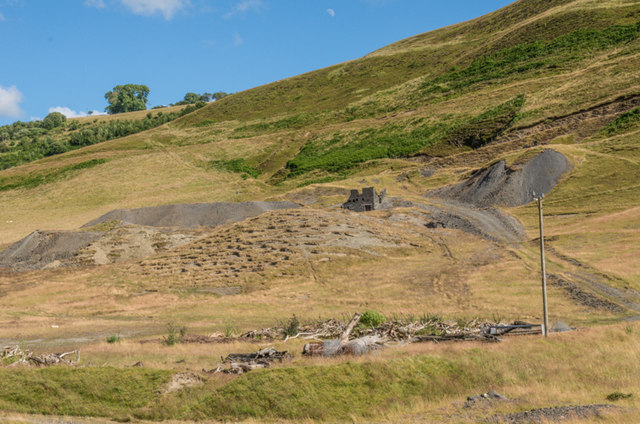
The remains are well preserved. In 2014 grey spoil tips and a small roofless building stood on the open hillside.
A wheelpit, flat-rod run and engine pit that survive together, a crusher house, collapsing buddles, well-preserved slime pits, shaft and level entrances, the remains of buildings, and tips.
Related mines
- Wemyss Mine — A leat once carried water on from the Wemyss mine to Graig Goch, down the valley.
Nearby mines
- Frongoch Mine — 0.4 miles (0.7 km) NE
- Wemyss Mine — 0.7 miles (1.1 km) E
- Gwaithgoch Mine — 1.1 miles (1.7 km) SE
- Grogwynion Mine — 1.4 miles (2.2 km) SE
- Blaencennant Mine — 1.9 miles (3.1 km) N
Straight-line distance, within 9 miles (15 km). Show on the map.
Further reading
The Royal Commission's site record, with the mine's periods of working and a list of what survives.
View sourceSources
- (primary) Lead and Zinc: The Mining District of North Cardiganshire and West Montgomeryshire (Special Reports on the Mineral Resources of Great Britain, vol. XX), O. T. Jones, 1922 — Memoirs of the Geological Survey
- (primary) Graig Goch Lead and Zinc Mine; Red Rock; Cwmnewyddion (NPRN 33824) — Coflein, Royal Commission on the Ancient and Historical Monuments of Wales
- (observational) Graig Goch Mine (Geograph photograph 4416890, 2014) — Geograph
- (primary) Mine plan: Red Rock or Graiggoch Mine, SN77SW 7 (KP17015) — British Geological Survey
- (primary) Mine plan: Red Rock Mine, sections of main and north lodes showing extent of workings — British Geological Survey
Record created: 18 November 2026 · Last researched: 18 November 2026