 MineArchive
Newlandside Quarry
| Also known as | Newlandside Quarries |
|---|---|
| Location | Stanhope, Weardale, County Durham — 54.7401, -2.0085 (approximate) |
| Commodities | Limestone, Fluorspar |
| Type | Quarry |
| Worked | 19th century–1980 |
| Maximum depth | A face in a limestone bed about 60 feet thick. |
| Operators | Bolckow, Vaughan and Company (1906–1910, owner) — Owners in the accident returns, 1906-1910 Walton's Alston Lime and Coal Company Ltd (owner) — Owners in the 1940s (Durham Mining Museum) |
A large limestone quarry on the hillside south-west of Stanhope in Weardale, worked from Victorian times and owned by Bolckow, Vaughan and Co. in the 1900s.
Location
Approximate location. The large pin is this mine; the small round markers are the nearest mines on record. Click one for its page. View on full map
History
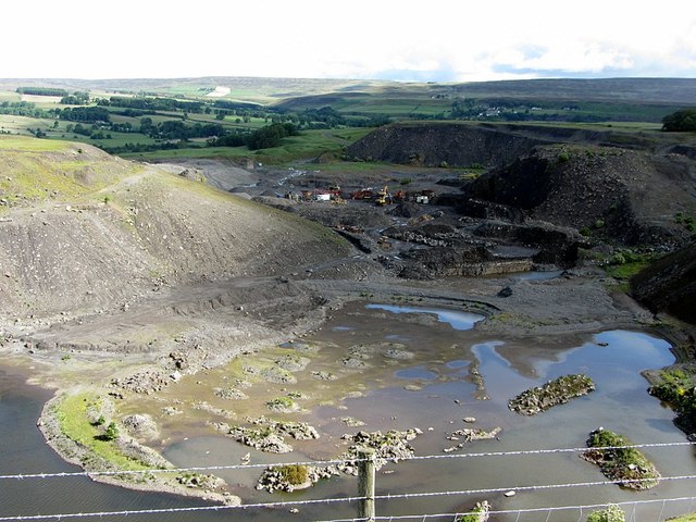
Newlandside was one of the two great limestone quarries on the hillside south-west of Stanhope. With Parson Byers, which adjoined it, it formed a continuous face three miles long, in a bed of limestone about 60 feet thick some 900 feet above sea level. The county's historic environment record dates the quarries to the 19th century. In 1896 Newlandside employed 240 people, and in 1897, 248.
Bolckow, Vaughan and Co. owned it in the 1900s. The workforce had fallen to 139 by 1905 and 73 by 1922. The accident returns record four quarrymen killed between 1906 and 1910, knocked from benches and panels by falling stone or caught by falls of rock and earth, and the Durham Mining Museum lists a fifth death in 1929. A trade-press description of 1937 shows how the place worked. Quarrymen in pairs loaded stone straight into trucks on standard-gauge track at the face, compressed-air drills and high explosives broke the rock, and a Ruston-Bucyrus steam excavator stripped the overburden. Saddle-tank locomotives took the trucks to the head of a self-acting incline, which delivered loaded 10-ton wagons to the LNER below. By 1940 only twelve were employed, and Walton's Alston Lime and Coal Company had it in the 1940s.
Planning permission for quarrying was granted in 1951, and working stopped in 1980. A mineral dealer instead gives 1983 for the closure and says the quarry reopened in 2021.
Geology
A bed of limestone about 60 feet thick, with veins carrying fluorite and galena in the quarry faces.
Workings
Open quarry faces on both sides of the road, about 68 hectares in all, with standard-gauge track at the face and a self-acting incline with 8-foot balanced drums down to the railway.
Closure
Working stopped in 1980 by one account and 1983 by another. An abandonment plan for opencast workings in the Little Limestone at the quarry is dated September 1976.
What remains
Disused, with restoration work removing old stockpiles and conserving wildlife habitat; one account says quarrying resumed in 2021.
The quarry faces and floors.
Redevelopment
Restoration for wildlife.
Related mines
- Parson Byers Quarry — The workings of Parson Byers and Newlandside joined, forming one continuous limestone quarry face three miles long (Durham Mining Museum, 1937 description).
Nearby mines
- Parson Byers Quarry — 0.8 miles (1.2 km) SE
- Ashes Quarry — 0.9 miles (1.4 km) N
- Greenfoot Quarry — 1.0 miles (1.6 km) NW
- Diana Maria Mine — 1.4 miles (2.2 km) W
- Rogerley Mine — 1.5 miles (2.4 km) E
Straight-line distance, within 9 miles (15 km).
Further reading
The museum's page: workforce from 1896 to 1940, owners in the 1940s, the 1937 description of the quarry and the men killed there.
View sourceThe historic environment record for the two quarries, dated to the 19th century.
View sourceThe national catalogue entry for an abandonment plan of opencast workings in the Little Limestone at Newlandside, dated 1976.
View sourceSources
- (primary) Newlandside Quarry (Durham Mining Museum) — Durham Mining Museum
- (primary) Newlandside Quarries (Keys to the Past, D63381) — Durham County Council and Northumberland County Council
- (secondary) NMRS deaths and injuries database: Newlandside Quarry, 1906 — Northern Mine Research Society
- (secondary) NMRS deaths and injuries database: Newlandside Quarry, 1909 — Northern Mine Research Society
- (secondary) NMRS deaths and injuries database: Newlandside Quarry, 1910 — Northern Mine Research Society
- (observational) Newlandside Quarry (Geograph, Andrew Curtis) — Geograph
- (secondary) Newlandside Quarry, Weardale (Albion Fire and Ice) — Albion Fire and Ice
- (primary) BGS mine plans: Newlandside Quarry (opencast), Little Limestone, abandoned September 1976 (D1580) — British Geological Survey
Record created: 20 November 2026 · Last researched: 20 November 2026