 MineArchive
Ashes Quarry
| Location | Stanhope, Weardale, County Durham — 54.7527, -2.0085 (approximate) |
|---|---|
| Commodity | Limestone |
| Type | Quarry |
| Worked | 1870s–late 1940s |
| Operators | Consett Iron Company (1900–?, owner) — Bought the quarry in 1900 for blast-furnace flux; owners in the 1909 accident return and the 1920s |
A mile-long limestone quarry above Stanhope in Weardale, bought by the Consett Iron Company in 1900 to supply flux for its furnaces and worked until the late 1940s.
Location
Approximate location. The large pin is this mine; the small round markers are the nearest mines on record. Click one for its page. View on full map
History
Ashes Quarry lies on the hillside between Stanhope and Crawleyside in Weardale. Limestone quarrying began there in the 1870s, near the foot of the Crawleyside incline. Loaded wagons were hauled more than a mile and a half up the incline to nearly 1,500 feet by a system of ropes, gravity and winding engines, with fixed steam engines at top and bottom. The stone went to lime kilns and, above all, to the blast furnaces at Consett, where it served as a flux.
It employed 125 people in 1896 and 129 in 1905. The Consett Iron Company bought it in 1900 to secure limestone for its expanding steelworks, and at its height, at the start of the First World War, the quarry produced 136,000 tons of limestone in a year. By 1920 about 200 men worked there (175 in 1922). They worked in pairs, often father and son or two brothers, each pair taking a panel of the face 10 to 15 metres long, and the best could fill two wagons, 24 tons, in a day. The accident returns include a blacksmith of 75 who died of shock in 1909 after setting his shirt alight at the smithy hearth, and a labourer killed in 1928 when timber falling from a tunnel roof knocked him off the buffers he was riding.
As the face worked deeper into the hill, the sandstone and shale overburden that had to be stripped first grew thicker, until quarrying no longer paid. Production finally stopped in the late 1940s.
Geology
The Great Limestone, under a thickening cover of sandstone and shale.
Workings
A long open face worked in panels by pairs of quarrymen, with the stone hauled up the Crawleyside incline to the railway.
Closure
Production stopped in the late 1940s when the growing overburden made quarrying uneconomic.
What remains
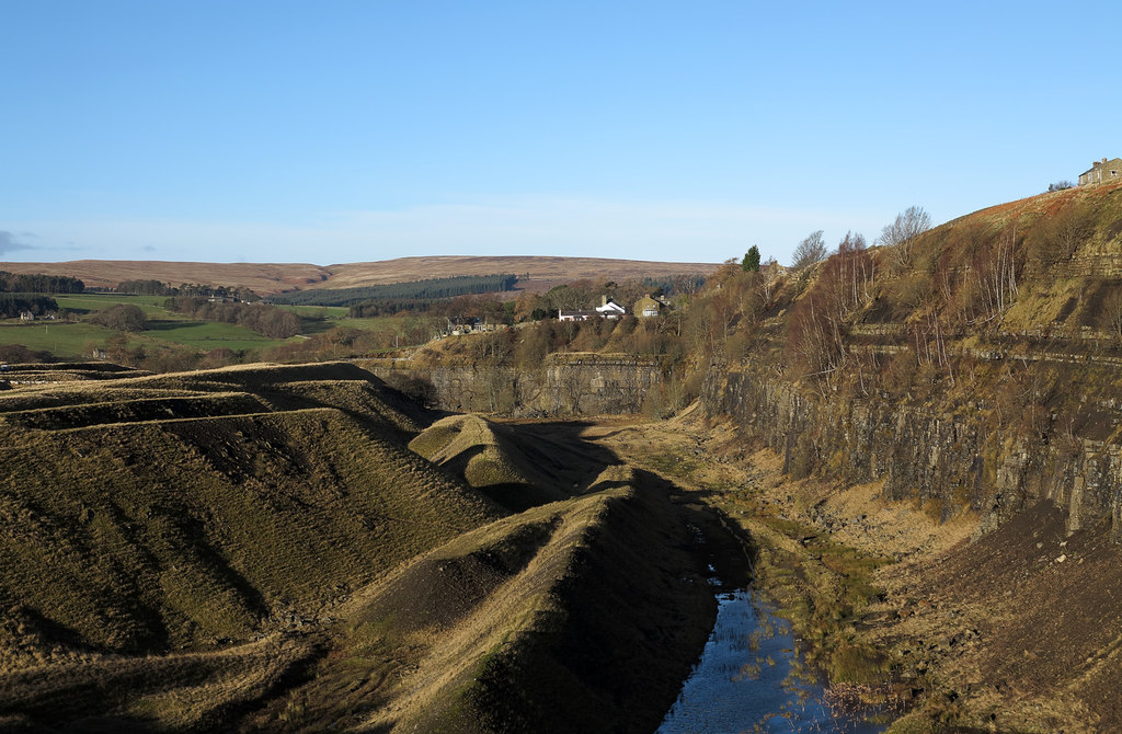
A disused excavation about a mile long in two sections, crossed by a footpath on two iron bridges, with a lake in the quarry floor.
The quarry faces, waste banks, two iron bridges and the line of the Crawleyside incline.
Nearby mines
- Greenfoot Quarry — 0.9 miles (1.4 km) W
- Newlandside Quarry — 0.9 miles (1.4 km) S
- Stanhopeburn Mine — 1.1 miles (1.8 km) W
- Parson Byers Quarry — 1.6 miles (2.5 km) S
- Diana Maria Mine — 1.7 miles (2.7 km) SW
Straight-line distance, within 9 miles (15 km).
Further reading
A history of the quarry quoting the North Pennines AONB Partnership: the incline, the Consett purchase of 1900, output, the quarrymen's work and the closure.
View sourceThe museum's page: workforce from 1896 to 1922, the 1920s owner and the men killed there.
View sourceSources
- (secondary) Ashes Quarry, Crawleyside (co-curate, Newcastle University, quoting the North Pennines AONB Partnership) — Newcastle University
- (primary) Ashes Quarry (Durham Mining Museum) — Durham Mining Museum
- (secondary) NMRS deaths and injuries database: Ashes Quarry, 1909 — Northern Mine Research Society
- (secondary) The Quarry Walk (Living North, February 2023) — Living North
- (observational) Ashes Quarry, western section (Geograph) — Geograph
Record created: 20 November 2026 · Last researched: 20 November 2026