 MineArchive
Greenfoot Quarry
| Location | Stanhope, Weardale, County Durham — 54.7483, -2.0286 (exact) |
|---|---|
| Commodities | Whinstone, Limestone |
| Type | Quarry |
| Worked | by 1896 |
| Maximum depth | Up to 12 metres of dolerite exposed. |
| Operators | R. Summerson and Co. (1904–?, owner) — Owners in the 1904 accident return and the 1920s (Durham Mining Museum) |
A disused whinstone and limestone quarry a kilometre upstream of Stanhope in Weardale, now protected as the most complete exposure of the Little Whin Sill.
Location
Recorded location. The large pin is this mine; the small round markers are the nearest mines on record. Click one for its page. View on full map
History
Greenfoot Quarry lies in the Wear valley about a kilometre upstream of Stanhope, cut into the Little Whin Sill, a sheet of dolerite intruded between beds of limestone. It raised whinstone and limestone in 1896 and 1897, with 48 and 49 people, and by 1905 whinstone alone, still with 48. In 1922 it was returned as an igneous rock quarry employing 32.
R. Summerson and Co. Ltd owned it in 1904 and again in the 1920s. In January 1904 a quarryman was killed and his partner injured when a 40-pound charge went off as they loaded a 12-foot hole that had already been fired three times.
The quarry was later abandoned. In 1984 it was notified as a Site of Special Scientific Interest, chosen through the Geological Conservation Review as the most complete exposure of the Little Whin Sill. That rock is less magmatically evolved than the Great Whin Sill and, unusually among the Whin rocks, contains olivine.
Geology
Up to 12 metres of Little Whin Sill dolerite intruded between strata of the Three Yard Limestone, which it slightly metamorphosed; the sill contains olivine and shows columnar jointing at the western end of the quarry.
Workings
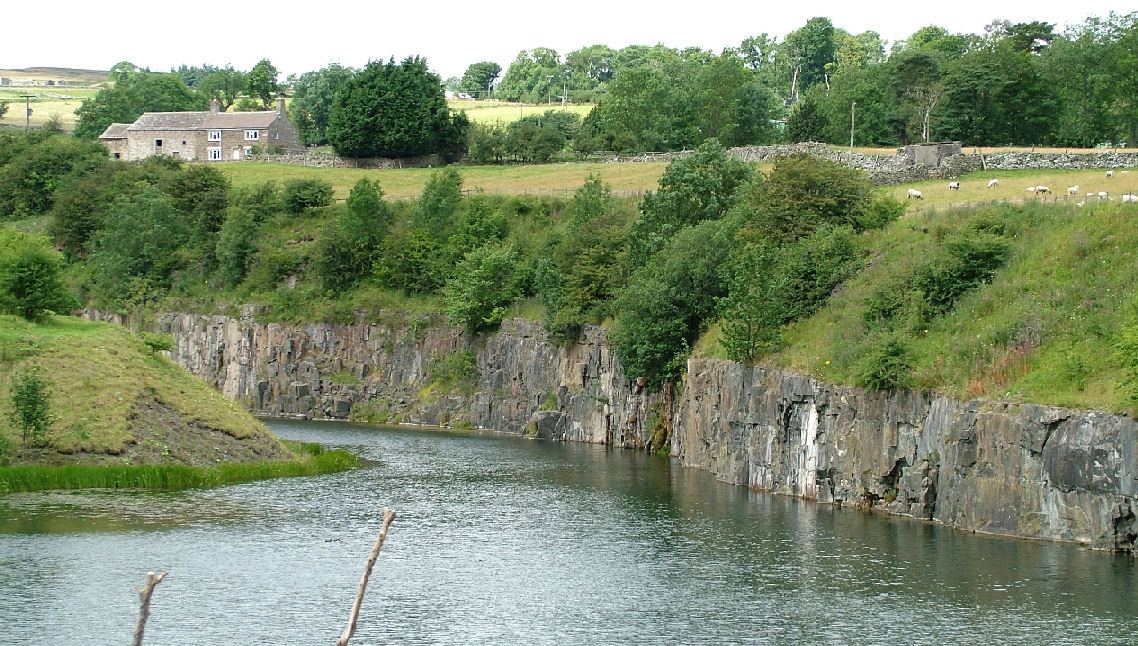
An open quarry face in the sill and the limestone around it.
Closure
Abandoned before its notification as a Site of Special Scientific Interest in 1984.
What remains
A disused, flooded quarry of 0.9 hectares, protected as a Site of Special Scientific Interest for its geology.
The quarry faces, including a long section of the sill's upper contact with the limestone on the south-facing wall.
Redevelopment
Protected as a geological Site of Special Scientific Interest since 1984.
Nearby mines
- Diana Maria Mine — 0.8 miles (1.3 km) SW
- Stanhopeburn Mine — 0.8 miles (1.3 km) N
- Ashes Quarry — 0.9 miles (1.4 km) E
- Newlandside Quarry — 1.0 miles (1.6 km) SE
- Parson Byers Quarry — 1.7 miles (2.7 km) SE
Straight-line distance, within 9 miles (15 km).
Further reading
The museum's page: output and workforce from 1896 to 1922, the 1920s owner and the 1904 death.
View sourceThe official reasons for notification in 1984: the quarry's exposure of the Little Whin Sill.
View sourceSources
- (primary) Greenfoot Quarry (Durham Mining Museum) — Durham Mining Museum
- (secondary) NMRS deaths and injuries database: Greenfoot Quarry, Stanhope, 1904 — Northern Mine Research Society
- (primary) Greenfoot Quarry SSSI citation (Natural England) — Natural England
- (secondary) Greenfoot Quarry (Wikipedia) — Wikipedia
Record created: 20 November 2026 · Last researched: 20 November 2026