 MineArchive
Long Rake Spar Mine
| Location | Youlgreave, Derbyshire — 53.1758, -1.7162 (exact) |
|---|---|
| Commodities | Calcite, Fluorspar, Lead |
| Type | Mineral |
| Worked | 1867–1981 (underground) |
| Maximum depth | 420 feet |
| Operators | Derbyshire Silica Firebrick Company (?–1985), W.G. Cooke and Co., Long Rake Spar Mining Company |
Overview
A fluorspar, calcite and lead mine on one of Derbyshire's longest rakes, whose underground workings closed in 1981 but whose surface processing operation, under the same company name, continues to this day.
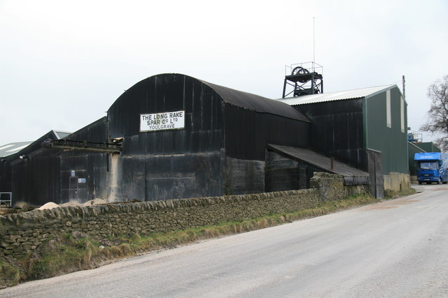
History
W.G. Cooke and Co. opened Long Rake in 1867, with production underway by 1872. Landowner Thomas Shimwell bought the mine around 1877 and renamed the business the Long Rake Spar Mining Company in 1881, shifting its focus to calcite — sold commercially as 'Derbyshire Spar' — alongside lead and fluorspar. James Moores bought the mine in 1910, though records suggest he may not have actively worked it. Output peaked in the 1920s under Captain Percy Potter, with around twelve miners raising some 12,000 tonnes of fluorspar and 100 tonnes of lead ore a year; electric haulage, with locomotives and wagons from Greenwood and Batley of Leeds, was introduced in 1936. By 1904 Long Rake Spar was the only mine still working in what had once been Youlgreave's busy lead-mining parish. Underground extraction finally stopped in 1981 once falling spar prices made it uneconomic, but the company's surface processing operation has continued ever since.
Geology
Long Rake is one of the longest mineral rakes in Derbyshire, with impressively wide open sections at surface; huge blocks of chert form part of the rake's walls.
Workings
Underground working reached three levels, at 300, 375 and 420 feet, connected by ring-arched tramway levels, timber ore chutes and an engine shaft; a horizontal winding engine and later headgear served the shaft from the surface.
Closure
The underground workings are long abandoned and only partly accessible; cavers report multiple roof collapses blocking sections of them.
What remains
The underground workings are long abandoned and only partly accessible — cavers report multiple roof collapses blocking sections of the mine, and unstable ground near the main access route. The surface site remains a working aggregate business under the same company name.
Surface structures include 20th-century headgear and a horizontal winding engine house.
Nearby mines
- Mandale Mine — 1.2 miles (1.9 km) N
- Alport Mines — 1.4 miles (2.3 km) NE
- Mawstone Mine — 1.4 miles (2.3 km) SE
- Broadmeadow Lead Mine — 1.9 miles (3.1 km) E
- Guy Mine — 1.9 miles (3.1 km) E
Straight-line distance, within 9 miles (15 km). Show on the map.
Recorded claims
Individual factual claims, each attached to the source(s) that support it below. Where sources disagree, both are kept.
- James Moores bought the mine in 1910, though surviving records suggest he may not have actively worked it. 1
- A July 2025 exploration report found multiple accessible levels (300ft and 375ft) but noted collapses blocking several passages, an unstable entry route, and a muddy 375ft level judged too risky to push further. 2
- The Historic Environment Record places the mine at SK 19065 64337 and notes that of five lead mines listed in Youlgreave parish in 1857 only the Long Rake Spar Company remained by 1904; its twentieth-century headgear and single-storey horizontal winding engine house stand over a main engine shaft no longer safely reachable from the surface. 1
- Thomas Shimwell gave the mine to his daughter Mary in 1913, from which the Long Rake Spar Company took its present form; Captain Potter sold the business to Derbyshire Silica Firebrick in the 1970s, and the Broadhurst family bought it in 1985 and turned it towards aggregates. 3
Sources
- (primary) Long Rake Mine, Youlgreave — Derbyshire Historic Environment Record
- (observational) Long Rake Spar Mine, nr Bakewell, Derbyshire, July 2025 — 28DaysLater
- (secondary) Long Rake Spar Mine
- (primary) Long Rake Mine Plans (Mining Remediation Authority, catalogue OM17932 / OM15330) — British Geological Survey / Mining Remediation Authority
Record created: 22 August 2026 · Last researched: 24 September 2026