 MineArchive
Levenseat Limestone Mines
| Location | Leven Seat and Handaxwood, south of Fauldhouse, West Calder parish, West Lothian (formerly Midlothian), West Lothian — 55.8002, -3.6824 (approximate) |
|---|---|
| Commodities | Limestone, Fireclay |
| Type | Stone |
| Worked | By 1837–c.1967 |
| Maximum depth | 20 fathoms (37 m), Levenseat No. 2 pit |
| Operators | Peter Mitchell & Son (?–1900), General Refractories Ltd. (1935–1948), Glenboig Union Fireclay Company (?–1967) |
Overview
Limestone mines under Leven Seat, on the Handaxwood lands south of Fauldhouse, worked from at least the 1830s until about 1900, followed by fireclay mines from the 1930s to the 1960s. The hill's quarries were later turned to sand, and a line of old quarries and collapsed mine entrances still marks the limestone outcrop.
History
Limestone was mined beneath Leven Seat, on the lands of Handaxwood south of Fauldhouse in West Calder parish, from at least the 1830s. In 1837 the Highland and Agricultural Society described Levenseat Quarry, rented by a Mr Cunningham, as worked entirely by mining: a bed of limestone seven or eight feet thick, dipping north-east at 20 degrees, was followed by a main passage about 250 yards long with chambers and pillars, the pillars being cut out as the worked ground was packed with waste. Ten men at 11 shillings a week and three horses were employed, and 12,000 bolls of lime a year were sold. A nineteenth-century account of the parish noted several draw kilns at work at Handaxwood.
The Castlecary limestone was later worked from Levenseat No. 1 pit, closed in 1878, and No. 1 mine, closed in 1888, and from Peter Mitchell and Son's Nos. 2 and 3 pits and Levenseat High Mine, whose workings ran southward beneath the summit until March 1900. A map of 1922 marks a tramway into the old quarry, presumably to reach adits in its face. Ironstone mining and most limestone working on the hill had ended in the first decade of the 20th century.
Fireclay followed. General Refractories Ltd drove the short-lived Levenseat Nos. 1 and 2 fireclay mines about 1935-36, and Levenseat Nos. 3 and 4 worked the Lower Millstone Grit fireclay, No. 3 employing 23 in 1948; owned latterly by the Glenboig Union Fireclay Company, they closed in 1963 and about 1967. The hill's quarries were then given over to sandstone and silica sand; the Levenseat sand quarry still works, and other old workings have become landfill and, since 2015, an energy-from-waste plant.
Geology
The Castlecary limestone of the Upper Limestone Formation, a bed seven or eight feet thick dipping north-east at about 20 degrees, with clayband ironstone, and the Lower Millstone Grit (Glenboig Lower) fireclay of the Passage Formation above.
Workings
Limestone was worked by stoop and room from quarry adits and from Levenseat Nos. 1-3 pits (No. 2 at 20 fathoms, No. 3 at 13), No. 1 mine and the High Mine; fireclay from Levenseat Nos. 1 to 4 fireclay mines in the 1930s to 1960s.
Closure
The limestone mines closed between 1878 and March 1900, with the quarry adits disused after 1920; the last fireclay mines closed in 1963 and about 1967.
What remains
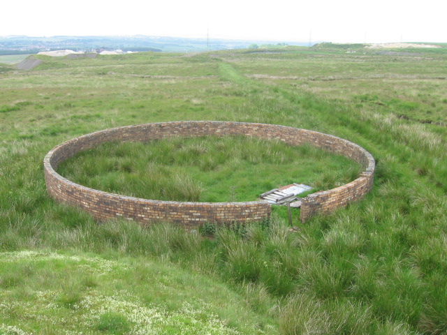
A line of old quarries marks the limestone outcrop, and collapsed mine entrances, shakeholes and shafts survive at Risland Knowes; the old quarry with adits in its wall remains, overgrown. Wind turbines now stand around the site of the limestone mine.
Old limestone quarries, collapsed mine entrances, shakeholes and shafts, and subsidence at the No. 1 mine entrance.
Redevelopment
Silica sand quarrying (still working), landfill and an energy-from-waste plant on the old quarry ground, and a windfarm.
Nearby mines
- Muldron Ironstone Pits — 1.1 miles (1.7 km) W
- Knowes Colliery — 1.5 miles (2.4 km) NW
- Wilsontown Ironworks — 1.7 miles (2.8 km) S, South Lanarkshire
- Southfield Colliery — 1.9 miles (3.0 km) NW, North Lanarkshire
- Fauldhouse Colliery — 1.9 miles (3.1 km) NW
Straight-line distance, within 9 miles (15 km). Show on the map.
Recorded claims
Individual factual claims, each attached to the source(s) that support it below. Where sources disagree, both are kept.
- In 1837 Levenseat Quarry was worked entirely by mining a limestone bed 7 or 8 feet thick along a main passage about 250 yards long; ten men and three horses were employed and 12,000 bolls of lime sold a year. 1
- Peter Mitchell and Son's Levenseat High Mine, to the Castlecary limestone, closed in March 1900. 2
- Ironstone mining and most limestone working on Leven Seat ended in the first decade of the 20th century. 3
- Levenseat No. 3 fireclay mine, owned by General Refractories Ltd, employed 19 underground and 4 on the surface in 1948 and closed in 1963. 4
- A line of old quarries delineates the limestone outcrop on Leven Seat, and several mine entrances can be seen nearby. 3,5
Photographs & further reading
The quarry and adits, with the 1837 description of the limestone mine.
View sourceSources
- (secondary) Scottish Shale: Levenseat quarry limestone mines — Scottish Shale (Museum of the Scottish Shale Oil Industry, Almond Valley Heritage Trust)
- (secondary) Scottish Shale: Levenseat High mine — Scottish Shale (Museum of the Scottish Shale Oil Industry, Almond Valley Heritage Trust)
- (secondary) Scottish Cave and Mine Database: Leven Seat [Overview] — Scottish Cave and Mine Database (Grampian Speleological Group)
- (secondary) Scottish Shale: Levenseat No.3 fireclay mine — Scottish Shale (Museum of the Scottish Shale Oil Industry, Almond Valley Heritage Trust)
- (secondary) West Lothian Council: 24. Levenseat quarries & mines, south of Fauldhouse (Local Geodiversity Sites) — West Lothian Council
- (secondary) History of West Calder, chapter 7 (Electric Scotland) — Electric Scotland
- (secondary) Scottish Shale: Levenseat No.1 & 2 fireclay mine — Scottish Shale (Museum of the Scottish Shale Oil Industry, Almond Valley Heritage Trust)
- (secondary) Scottish Shale: Levenseat No.1 limestone mine — Scottish Shale (Museum of the Scottish Shale Oil Industry, Almond Valley Heritage Trust)
- (secondary) Scottish Shale: Levenseat No.1 limestone pit — Scottish Shale (Museum of the Scottish Shale Oil Industry, Almond Valley Heritage Trust)
- (secondary) Scottish Shale: Levenseat No.2 pit — Scottish Shale (Museum of the Scottish Shale Oil Industry, Almond Valley Heritage Trust)
- (secondary) Scottish Shale: Levenseat No.4 fireclay mine — Scottish Shale (Museum of the Scottish Shale Oil Industry, Almond Valley Heritage Trust)
- (secondary) West Lothian Council: 23. Levenseat working quarry, south of Fauldhouse (Local Geodiversity Sites) — West Lothian Council
Record created: 16 October 2026 · Last researched: 16 October 2026