 MineArchive
Keaglesborough Mine
| Also known as | Kekelles Burrowghe |
|---|---|
| Location | Between the Meavy and Newleycombe valleys, east end of Burrator Reservoir, Walkhampton, Devon — 50.5134, -4.0129 (exact) |
| Commodity | Tin |
| Type | Metal |
| Worked | from Early 16th century |
| Maximum depth | Unknown. |
Overview
A tin mine between the Meavy and Newleycombe valleys at the head of Burrator Reservoir, worked from the early sixteenth century, with two water-powered stamping mills and dressing floors added in the eighteenth and nineteenth centuries; their wheelpits survive.
History
Keaglesborough (recorded as Kekelles Burrowghe) Mine lies near the east end of Burrator Reservoir, between the Meavy and Newleycombe valleys, beside Riddipit and its gert. The mine is believed to have worked from the early sixteenth century on an openwork, the gert, with an adit driven beside it and at least one possible shaft.
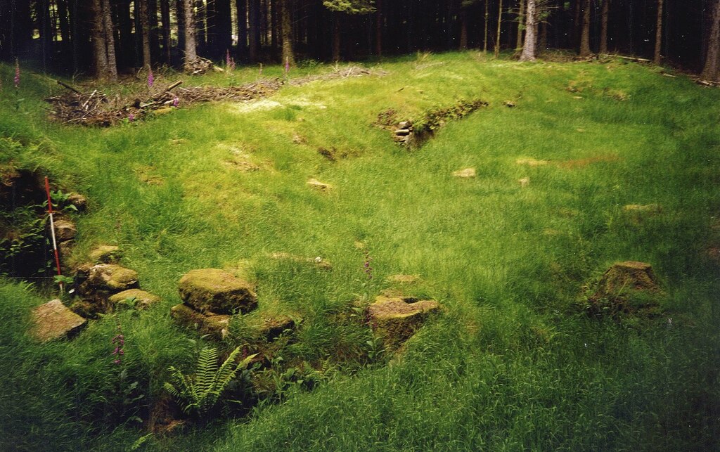
Its main processing works were added in the eighteenth and nineteenth centuries: two stamping mills, each with its dressing floor, where the ore was crushed and dressed. Water for the two wheels came by a leat taken from the River Meavy below Hart Tor, which crosses the Devonport Leat on Raddick Hill and reaches the upper mill on an embankment. Both mills survive as rectangular platforms, each with a stone-lined wheelpit at its centre, the upper one with its tail race; the smaller, lower wheelpit has also been suggested as a blowing house. The site is a scheduled monument with the neighbouring Riddipit farmstead, and lies in conifer woodland reached from Norsworthy Bridge.
Geology
Tin from a lode worked by an openwork (gert) in the Dartmoor granite.
Workings
An openwork (gert) with an adit and a possible shaft; two stamping mills with dressing floors, powered by two waterwheels fed by a leat from the River Meavy.
Closure
Unknown.
What remains
The two mill platforms with stone-lined wheelpits, the leat embankment, the gert and an adit survive in woodland.
Two wheelpits on mill platforms, a tail race, leat embankment, the gert and an adit.
Redevelopment
Conifer plantation around Burrator Reservoir.
Nearby mines
- Eylesbarrow Mine — 1.9 miles (3.1 km) SE
- Whiteworks Mine — 2.0 miles (3.2 km) NE
- Swelltor Quarry — 2.1 miles (3.4 km) NW
- Foggintor Quarry — 2.2 miles (3.5 km) N
- Merrivale Quarry — 3.5 miles (5.7 km) NW
Straight-line distance, within 9 miles (15 km). Show on the map.
What's uncertain
Points where sources disagree or the record could not be settled; both accounts are kept. All open questions in the archive.
- The smaller wheelpit of Keaglesborough Mine has been suggested as a blowing house. (uncertain) 3
Recorded claims
Individual factual claims, each attached to the source(s) that support it below. Where sources disagree, both are kept.
- Believed operational from the early 16th century, with the main processing facilities added in the 18th and 19th centuries. 1
- Two stamping mills with dressing floors survive as rectangular platforms, each with a stone-lined wheelpit. 1,2
- Water came by leat from the River Meavy below Hart Tor, crossing the Devonport Leat on Raddick Hill. 1
- Keaglesborough Mine has lower and upper dressing floors, wheel pits and a leat bank. 2,3
- The smaller wheelpit of Keaglesborough Mine has been suggested as a blowing house. (uncertain) 3
Sources
- (secondary) Keaglesborough Mine — Dartmoor Explorations
- (observational) Walk 2018-12-13: Norsworthy, Riddipit and Keaglesborough Mine — Dartmoor CAM Walks
- (observational) Walk 2016-6-23: Norsworthy Bridge, Keaglesborough Mine and Crazywell — Dartmoor CAM Walks
Record created: 17 October 2026 · Last researched: 17 October 2026