 MineArchive
Huglith Mine
| Also known as | Huglith Barytes Mine, Huglith Baryte Mine |
|---|---|
| Location | Habberley, near Minsterley, Shropshire — 52.6071, -2.8796 (approximate) |
| Commodities | Barite, Copper |
| Type | Mineral |
| Worked | c. 1800–1945 |
| Maximum depth | Over 70 m (about 230 ft) in the deepest shafts |
| Operators | Wotherton Barytes and Lead Mining Company (1910–?), Malehurst Barytes Co. Ltd (?–1945) |
Overview
Huglith worked barytes, and a little copper before it, on three veins in the Precambrian sandstones east of the Pontesford Fault, in the wooded hills between Habberley and Minsterley. Copper was the first target in the early 19th century and came to nothing; barytes was the business from 1910, and under the Malehurst Barytes Company the mine became the largest of its kind in Shropshire, sending its ore over the hills to the mill at Malehurst by aerial ropeway. It closed in 1945 having raised just under 300,000 tons, and the barite left standing in its stopes is now protected as a Site of Special Scientific Interest.
History
Mineral leases were being let at Huglith, in Pulverbatch parish, in the 1780s and 1790s, but the first real working came in the early 19th century and was for copper; it had finished by the 1860s without much to show. The ground was then left alone until 1910, when the Wotherton Barytes and Lead Mining Company took an interest in the area. Even then the scale stayed small, with production below a thousand tons a year, and the mine passed through several companies before it became the property of the Malehurst Barytes Company Ltd. That company invested in the workings and drove output up until Huglith was the largest barytes mine in Shropshire: by 1936 it was producing over twenty thousand tons of barite a year, the ore running about 95 per cent pure with silica as the main impurity. From 1925 the barytes went to Malehurst Mill, near Minsterley, on an aerial ropeway carried across the hills on pylons. There were originally two mines here, No. 1 and No. 2, but only No. 2 was ever developed to any extent. The mine closed in 1945, and the recorded total raised over its life was 295,108 tons of barite.
Geology
Huglith lies in the West Shropshire Orefield, in the Shelve-Habberley district, on the eastern side of the Pontesford Fault. That fault separates the Precambrian barium-copper ground on the east from the Ordovician lead-zinc-barium ground of the Shelve inlier to the west, and Huglith is one of a group of mines that worked barite and copper ores in the Precambrian rocks east of it. The Geological Conservation Review account names both the Wentnor Group and the Bayston-Oakswood Formation for the host strata: buff and grey coarse sandstones grading into sandy shales and mudstones, red or purple where unaltered and stained green or blue close to the veins by the oxidation of secondary copper minerals. The vein filling is thickly banded pink, red and sometimes white barite, swelling to six metres in places, the pink colour attributed to iron taken up from the surrounding rock, with traces of chalcocite, azurite and malachite and some quartz and occasional calcite. The barite is read as a late phase of the same mineralising event that produced the sulphides at Shelve, formed where rising saline fluids mixed with sulphate-rich water higher in the vein system; the whole orefield is dated between the early Devonian and the Westphalian and is grouped with Britain's Lower Carboniferous lead-zinc vein systems of Mississippi Valley type.
Geological setting: Hydrothermal Deposits (well documented example), Veins and Lodes (well documented example)
Workings
Three veins were worked: the Main Vein, also called No. 2 Vein, the Riddleswood Vein and the Mud Vein, all in steep south-dipping oblique-slip faults trending east-north-east. They ran up to 120 metres in worked length and two to six metres wide, and were taken out principally in stopes with shafts alongside, some of them sunk more than seventy metres. The Main Vein fault carries a right-lateral displacement of some 300 metres; its mineralisation is cut off underground by the Pontesford Fault at the western end and tapers out along strike after about 800 metres to the east. Underground the Main Vein ground was worked from Badger Level, which forks at the vein, one passage running to a stope with intermediate levels above it and the other to a winze dropping 110 feet to the main tramming level. At surface the Main Shaft stood among a winding engine house, compressor, boiler, transformer house and smithy, with the concrete pillars of the ropeway terminal beside them. The Mining Remediation Authority holds an abandonment plan of the barytes workings, catalogued OM15236 and drawn at 1:500 across nine sheets.
Closure
The mine closed in 1945, at the end of the wartime demand that had kept British barytes in production, with 295,108 tons recorded raised. Work in the district did not stop at once: the Sallies workings a little over a mile away continued until 1947, when the ropeway was closed and that mine abandoned in turn. No account read gives a reason for Huglith's own closure beyond the exhaustion of what could be worked economically.
What remains
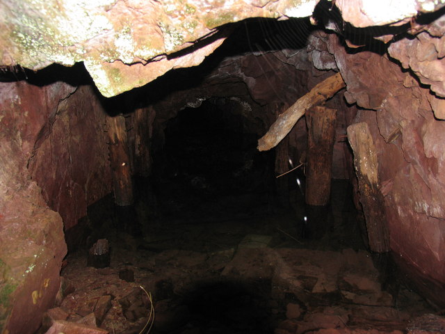
The mined area has been planted with trees, which makes the ground hard to follow, but the exposures themselves survive well: the line of the Main Vein can be traced up Westcott Hill, large stopes dominate its workings up the hillside, and patches of pink-white barite remain on either side of the fault planes, with arches of barite left standing where the vein was worked deep. The Geological Conservation Review rates this as one of the best exposures of barite mineralisation in England, and the site is now a Site of Special Scientific Interest, part of it on Forestry England land inside the Eastridge and Shelve Forest Plan. A 2006 photograph shows one adit standing full of water after its entrance cutting collapsed.
Numerous surface remains lie in the plantation around the Main Shaft: the foundations of the winding engine, compressor and boiler, a brick transformer house, a smithy, a metal chimney and the concrete pillars that carried the terminal of the aerial ropeway to Minsterley. The footings of the ropeway pylons can be found through the woodland along the line it took. Spoil, stopes worked to the surface and open vein courses remain on Westcott Hill.
Redevelopment
No redevelopment: the mine area was planted as forestry, and the barite exposures in the old workings are protected as a Site of Special Scientific Interest.
Nearby mines
- Burgham Mine — 1.8 km W
- Ladywell Mine — 2.0 km W
- Perkinsbeach Mine — 2.0 km W
- Myttonsbeach Mine — 2.2 km SW
- Snailbeach Mine — 3.3 km W
Straight-line distance, within 15 km. Show on the map.
Recorded claims
Individual factual claims, each attached to the source(s) that support it below. Where sources disagree, both are kept.
- 295,108 tons of barite were recorded raised at Huglith before it closed in 1945 -- just under 300,000 tons, the largest total of any barytes mine in Shropshire. 1,2
- By 1936 the mine was producing over 20,000 tons of barite a year and was the largest mine of its kind in the county; the ore ran about 95 per cent pure, with silica the main impurity. 1
- Three barite-rich veins were worked -- the Main or No. 2 Vein, the Riddleswood Vein and the Mud Vein -- up to 120 m long and 2 to 6 m wide, in steep south-dipping oblique-slip faults, with shafts sunk over 70 m in places. 1
- From 1925 the barytes was carried to Malehurst Mill, near Minsterley, by an aerial ropeway running across the hills on pylons; its concrete terminal pillars stand beside the Main Shaft. 3,4
- Huglith was first worked in the early 19th century for copper, with activity finishing by the 1860s; mineral leases had been let on the ground in the 1780s and 1790s. 2,3
- The mine was left until 1910, when the Wotherton Barytes and Lead Mining Company took an interest in the area, though production stayed below 1,000 tons a year at that stage. 2
- The disused mine is a Site of Special Scientific Interest for its geology, holding one of the best exposures of barite mineralisation in England in rocks of Precambrian age. 1,5
Photographs & further reading
The JNCC's site account: the orefield setting, the three veins, the output figures and what the exposures show today.
View sourceA short working history from copper in the early 19th century to closure in 1945, with photographs of the site.
View sourceAn account of the underground layout off Badger Level and of the surface remains and ropeway footings in the plantation.
View sourceLocation, grid reference and a bibliography of published accounts of the mine, including Dunham and Dines's wartime barium pamphlet.
View sourceSources
- (primary) Huglith Mine, Shropshire (Geological Conservation Review, Mineralization of England and Wales) — JNCC / Geological Conservation Review Series No. 36
- (secondary) Huglith Mine, Shropshire — sbury8 (Ian Cooper), Shropshire mines pages
- (secondary) Minerals and Mining - The Valley of Gatten, Part 5 — Pollardine Farm (James Lawson)
- (observational) Huglith & Westcott Mines — YoungManGoneWest
- (secondary) Huglith Mine — Wikipedia
- (observational) Abandoned adit, Huglith copper/barite mine (photograph, 2006) — Geograph Britain and Ireland
- (primary) Abandonment plan OM15236, HUGLITH (barytes) — BGS / Mining Remediation Authority mine plans catalogue
- (secondary) Huglith, copper and barytes mine (database entry) — Buddlepit Mine Database, Mining History Trust
Record created: 18 September 2026 · Last researched: 18 September 2026