 MineArchive
Cothercott Mine
| Also known as | Cothercott Baryte Mine |
|---|---|
| Location | Cothercott Hill, near Church Pulverbatch, Shropshire — 52.5967, -2.8627 (approximate) |
| Commodity | Barite |
| Type | Metal |
| Worked | 1910–1928 |
| Maximum depth | Unknown. |
Overview
A barytes mine on Cothercott Hill, near Church Pulverbatch in the Shropshire Hills, worked extensively between 1910 and 1928 and credited with 23,000 tons of very pure barytes. Its ore was ground between burr stones at a mill by the road on the hill, and after a quarrel with the County Council over its road locomotives it began a railway to the main line at Dorrington and gave up about a mile out.
History
Barytes, the heavy white mineral barium sulphate, was used as a filler in paint, paper, linoleum and pottery, and Cothercott Hill was worked for it chiefly between 1910 and 1928, in which time the mine produced some 23,000 tons of a very pure grade. The ore was ground at a mill beside the road on the hill, where burr stones did the work; one account gives six pairs of stones and another ten pairs of French burr stones. Before the First World War the mine had a steep tramway from its principal mining area down to a roadside loading dock, which later became the mill site. In 1920, after heated argument with the County Council over the damage its road locomotives were doing and the delays the state of the roads caused its own shipments, the mine decided to connect its line to the main railway at Dorrington, some four miles away. About a mile was built towards Castle Pulverbatch before the work stopped; Michael Shaw's history of the Shropshire mines leaves open whether the money ran out, the receiver stopped it or the success of petrol lorries made the line unnecessary. A recent account of the mill also records a brief reopening in 1934 and 1935.
Geology
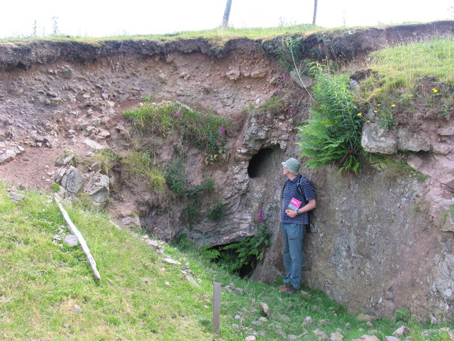
Barite, worked from a vein that is still exposed beside the old openings on the hill. Its width, trend and host rocks are not recorded.
Geological setting: Veins and Lodes (surviving physical example)
Workings
Adits and stopes on the vein, with spoil heaps on the hillside; one opening still leads into an open stope within the vein. A steep tramway ran from the principal working area down to the roadside loading dock and mill, and about a mile of an unfinished line towards Dorrington was built from 1920, its course still traceable across the fields.
Closure
Extensive working ended in 1928, for reasons that are not recorded. One recent account reports a brief reopening in 1934 and 1935.
What remains
The mill site beside the road is marked by concrete floors and machine bases with a number of the grinding stones. Under the Heritage Lottery Fund's Stiperstones and Corndon Hill Country Landscape Partnership Scheme the building remains were consolidated, burr stones were excavated and used to mount interpretation panels, and volunteers from the Shropshire Caving and Mining Club made measured surveys of the remains. A yellow-painted mine tub on a plinth recalls the railway, though a 2018 visitor notes it came from Gwynfynydd in Wales. On the hillside the adits and spoil heaps remain, and a 2006 photograph shows a barite vein exposed beside openings leading into a still-open stope.
Concrete mill floors and bases with a machine bed and burr stones by the road, the line of the tramway and of the unfinished Dorrington line, and adits, an open stope and spoil heaps on the hill.
Redevelopment
The mill site has been consolidated and interpreted as a heritage site under a landscape partnership scheme; there is no other redevelopment.
Nearby mines
- Huglith Mine — 1.6 km NW
- Burgham Mine — 2.9 km W
- Perkinsbeach Mine — 3.0 km W
- Gatten Mine — 3.1 km W
- Myttonsbeach Mine — 3.1 km W
Straight-line distance, within 15 km. Show on the map.
What's uncertain
Points where sources disagree or the record could not be settled; both accounts are kept. All open questions in the archive.
- The mill used six pairs of burr stones to grind the barytes. (disputed) 2
- The ore was ground at the mill using ten pairs of French burr stones, some of which were later excavated and used to mount interpretation panels. (disputed) 1
- The mine and mill were briefly reopened in 1934 and 1935. (uncertain) 5
Recorded claims
Individual factual claims, each attached to the source(s) that support it below. Where sources disagree, both are kept.
- The mine was worked extensively between 1910 and 1928 and produced a total of 23,000 tons of very pure barytes. 1,2
- The mill used six pairs of burr stones to grind the barytes. (disputed) 2
- The ore was ground at the mill using ten pairs of French burr stones, some of which were later excavated and used to mount interpretation panels. (disputed) 1
- Before the First World War the mine had a steep tramway from its principal mining area to a roadside loading dock, later the mill site. 3
- In 1920, after disputes with the County Council over damage done by its road locomotives, the mine decided to build a line to the main railway at Dorrington; about a mile was built towards Castle Pulverbatch before work stopped. 3,4
- The mine and mill were briefly reopened in 1934 and 1935. (uncertain) 5
- The mill building remains were consolidated and interpreted under the Stiperstones and Corndon Hill Country Landscape Partnership Scheme, with measured surveys by the Shropshire Caving and Mining Club. 1,6
Photographs & further reading
Shropshire Council's account of the mine's working dates, its mill and the remains on Cothercott Hill.
View sourceLists Michael Shaw's 'Mining on Cothercott Hill', on the Cothercott and Wilderley mines and their transport.
View sourceThe line of the unfinished tramway from the mine towards Dorrington, with an earlier, steeper attempt beside it.
View sourceSources
- (secondary) Uncovering the History of Lead and Barytes Mining (case study) — National Association for Areas of Outstanding Natural Beauty
- (secondary) Medieval Mottes, Barytes Mining & Ancient Lanes — Shropshire's Great Outdoors (Shropshire Council)
- (secondary) A lost railway in the Shropshire hills — Liberal England (Jonathan Calder), quoting Michael Shaw, The Lead, Copper and Barytes Mines of Shropshire, p. 58
- (observational) Old Tramway (photograph, 2005) — Geograph Britain and Ireland
- (observational) Cothercott Barytes Mill (photograph, Dave Croker) — Geograph Britain and Ireland
- (observational) Cothercott — geoffspages.blog
- (observational) Disused barite workings, former Cothercott mine (photograph, 2006) — Geograph Britain and Ireland
- (observational) Mill building remains (photograph, 2005) — Geograph Britain and Ireland
Record created: 18 September 2026 · Last researched: 18 September 2026