 MineArchive
Hobbs Hill Tin Mine
| Also known as | Hobb's Hill Tin Mine, Hobbys Worke |
|---|---|
| Location | Hobbs Hill, near St Neot, Bodmin Moor, Cornwall — 50.4955, -4.5584 (approximate) |
| Commodity | Tin |
| Type | Metal |
| Worked | 1844 (tinwork by 1516)–Early 20th century |
| Maximum depth | 36 fathoms (about 66 m): the shaft, sunk by 1846. |
| Operators | Kingsway Syndicate Ltd |
Overview
A small water-powered tin mine on the slopes of Hobbs Hill above the River Loveny near St Neot, begun in 1844 and abandoned in 1849, reopened in 1872 as an openwork on a tin-bearing elvan dyke, and worked a last time early in the 20th century with its own small hydro-electric station. Beside it lies a far older lodeback tinwork, probably the 'Hobbys Worke' that existed by 1516.
History
The mine on Hobbs Hill was established in 1844, and by 1846 an adit and a shaft 36 fathoms deep had been driven. The ground proved difficult and the venture was abandoned in 1849; whether it ever sold any tin is not known. Many of the buildings on the site belong to this first phase: terraces cut into the steep east-facing slope carry the stamps, wheelpits, dressing floor and ancillary buildings, reached by a series of trackways. The stamps were driven by waterwheels more than 40 metres to the north, the power carried to them by flat rods.
The mine reopened in 1872 on a different target, a mineralised elvan dyke north of the processing area, which was worked from the surface as an openwork. At least seven stopes, each a steep rock face, step down through it. Between 1872 and 1874 it produced 15 tons of black tin, and the stamps, dressing floors and buildings were probably refurbished for the work. A small building beside the mine leat 80 metres north of the openwork is thought to have been the magazine for its explosives.
The last phase came early in the 20th century, when Kingsway Syndicate Ltd employed 13 miners here. A small hydro-electric power station beside the Loveny probably dates from this period: water reached its turbine by a pipe from a small triangular concrete reservoir, and the electricity drove the crushing and dressing machinery. The Cornwall and Scilly Historic Environment Record describes the whole as a small tin mine worked intermittently from 1844, with an openwork and dumps, an adit near stream level, an early 20th-century stamping and processing floor, a leat serving a turbine or Pelton wheel, a magazine, a count house, a smithy and two wheelpits belonging to an earlier dressing floor.
West of the 19th-century mine is a much older lodeback tinwork: a line of pits sunk onto the back of a lode, smaller prospecting pits beside them and two small tinners' shelters. It may be the 'Hobbys Worke' that existed by 1516. A leat of the same period runs towards the deepest pit at a height which suggests a waterwheel stood over it to lift or pump, of the kind shown in 16th-century German engravings; this is the only place in south-west England where archaeological evidence for such a wheel at a tinwork has been found. A larger leat running between the openwork and the old tinwork was cut in 1846 to carry water from West Colliford to Wheal Friendship on Goonzion Downs. The mine, openwork and tinwork were scheduled together on 19 January 2011.
Geology
The later mine worked a mineralised elvan dyke north of the processing area, taken from the surface as an openwork. The early tinwork to the west followed the back of a tin lode where it came close to the surface. The 1840s mine was given up because of adverse ground.
Geological setting: Veins and Lodes (historical documentary reference)
Workings
An adit with its dumps and a shaft of 36 fathoms, both driven by 1846, south and south-west of the processing floors; an openwork of at least seven stopes on the elvan dyke, worked from 1872; water-powered stamps driven by flat rods from waterwheels 40 metres to the north; a dressing floor with at least three circular buddles; and in the last phase an electric plant fed by a turbine on the Loveny. West of the mine, pits along the back of a lode and lines of prospecting pits.
Closure
The first mine was abandoned in 1849 in adverse ground, perhaps without selling any tin. The openwork produced 15 tons of black tin between 1872 and 1874. The final working, by Kingsway Syndicate Ltd with 13 men early in the 20th century, has no known closing date.
What remains
Scheduled monument (list entry 1021410), in woodland on the slopes of Hobbs Hill. Historic England judges the remains to survive very well, with the dressing floors intact and the hydro-electric station almost certainly unique.
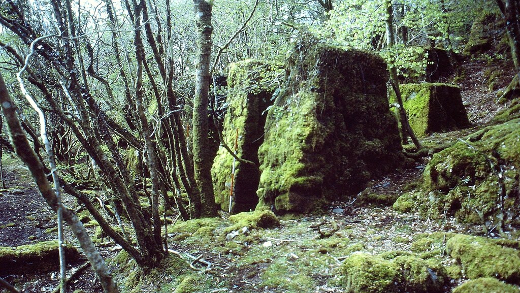
Terraced processing floors with the stamps, wheelpits and at least three circular buddles; the adit and its dumps; the stepped openwork; the probable magazine; the power station, its concrete reservoir and the stone piers that carried its pipeline; drystone building footings; and to the west the pits, shelters and leat of the lodeback tinwork. A 1986 photograph shows the moss-covered masonry of the stamps among trees.
Redevelopment
None: the site survives as a scheduled monument.
Nearby mines
- Herodsfoot Mine — 4.0 miles (6.4 km) S
- South Caradon Mine — 4.8 miles (7.7 km) E
- Cheesewring Quarry — 4.8 miles (7.8 km) NE
- Gonamena — 4.9 miles (7.8 km) E
- Marke Valley Mine — 5.0 miles (8.0 km) NE
Straight-line distance, within 9 miles (15 km). Show on the map.
What's uncertain
Points where sources disagree or the record could not be settled; both accounts are kept. All open questions in the archive.
- The lodeback tinwork west of the mine may be the 'Hobbys Worke' recorded by 1516. (uncertain) 1
Recorded claims
Individual factual claims, each attached to the source(s) that support it below. Where sources disagree, both are kept.
- Established in 1844; by 1846 an adit and a 36-fathom shaft had been driven. 1
- Abandoned in 1849 because of adverse geological conditions. 1
- Reopened in 1872 as an openwork on a mineralised elvan dyke, producing 15 tons of black tin between 1872 and 1874. 1
- Worked early in the 20th century by Kingsway Syndicate Ltd, which employed 13 miners. 1
- A small tin mine that worked intermittently from 1844. 2
- The site includes an early 20th-century stamping and processing floor, a leat serving a water turbine or Pelton wheel, a magazine, a count house, a smithy and two wheelpits of an earlier dressing floor. 2
- A 1986 photograph shows the water-powered stamps surviving as moss-covered masonry among trees. 3
- The lodeback tinwork west of the mine may be the 'Hobbys Worke' recorded by 1516. (uncertain) 1
Photographs & further reading
Sandy Gerrard's 1986 photograph of the water-powered stamps.
View sourceThe scheduling description of the mine, openwork, hydro-electric station and 16th-century lodeback tinwork.
View sourceThe county record of the mine and its parts, from the 1986 and 1988 field surveys.
View sourceSources
- (primary) Hobbs Hill tin mine, openwork and lodeback tinwork 530m east and 160m north east of Chyseger Farm (List entry 1021410) — Historic England
- (primary) HOBBS HILL - Post Medieval mine (Cornwall and Scilly HER 12174) — Cornwall and Scilly Historic Environment Record (Heritage Gateway)
- (observational) Hobb's Hill Tin Mine Stamps (Geograph 6750581) — Geograph
Record created: 22 September 2026 · Last researched: 29 September 2026