 MineArchive
Highley Colliery
| Also known as | Highley Mining Company Colliery |
|---|---|
| Location | Highley, west of the River Severn, Shropshire — 52.4470, -2.3820 (approximate) |
| Commodity | Coal |
| Type | Coal |
| Worked | 1878–1940 (shaft kept for ventilation) |
| Maximum depth | Coal struck at 300 yards |
| Operators | Highley Mining Company (1878–1940) |
Overview
The colliery that made Highley. Sunk from 1878 by the Highley Mining Company, a syndicate of North Staffordshire mine owners, it struck the Broach coal at 300 yards a year later and grew into one of the largest pits of the Wyre Forest Coalfield, employing 670 by 1937. Its workings ran out beneath the River Severn towards Alveley, and once a new shaft on the far bank had met them in 1937 the men and machinery were moved across. Highley itself closed by 1940, the shaft kept for ventilation and escape.
History
The Highley Mining Company was formed in 1877 to mine coal at Highley, founded by a group of North Staffordshire mine owners. They began sinking their main shaft in 1878 and found the Broach coal a little over a year later, at 300 yards. Mining conditions were good, the colliery was quickly connected to the Severn Valley Railway at Highley Station, and it became very profitable; one of the main destinations for the coal was the carpet factories of Kidderminster. The company expanded across the Wyre Forest Coalfield. From the early 1890s it prospected in the neighbouring parish of Kinlet, striking coal there in 1894, and in 1915 it took over Billingsley Colliery. In 1914, 391 men worked at Highley and 306 at Kinlet; Billingsley added another 202. The village of Highley grew fourfold between 1875 and 1915 to house them, and took on the amenities of a small town — the red-brick terraces are still its distinctive mark. Highley itself received regular investment and its workforce rose to 670 by 1937. But the coal was running out eastward: the workings had gone under the River Severn towards Alveley, and in 1935 the company sank a new shaft on the far bank. The two sets of workings met in 1937, and men and equipment were transferred across. The Highley shaft closed in 1939, with all production brought to the surface at Alveley from then on; by 1940 the colliery itself had shut, though the pithead was kept open for ventilation and as an emergency escape. Its railway sidings became the landsale yard for Alveley.
Geology
The Wyre Forest Coalfield, which runs about eighteen miles north to south — from near Harpswood south-west of Bridgnorth to near Abberley south-west of Kidderminster — and is up to six miles wide. Coal has been worked in it from surface outcrops down to about 900 feet. At Highley the Broach coal was struck at 300 yards and mining conditions were good, in contrast to Kinlet a few miles south, where basalt intruded on the only productive seam.
Workings
A shaft colliery about 300 yards uphill from Highley Station and west of the Severn. Main-line railway trucks were filled at the colliery and run down a standard-gauge incline to sidings beside the Severn Valley Railway south of the station — the site now occupied by the railway’s Engine House. As the workings advanced east they passed beneath the river towards Alveley, and after the two collieries met underground in 1937 the Highley shaft served only for ventilation and escape.
Closure
Highley did not fail; it was superseded. The shaft closed in 1939 once the Alveley shaft could take all the production, and the colliery itself had shut by 1940 — but the same coal went on being worked from the other bank for another thirty years, and the pithead here stayed open for ventilation and as an emergency evacuation route.
What remains
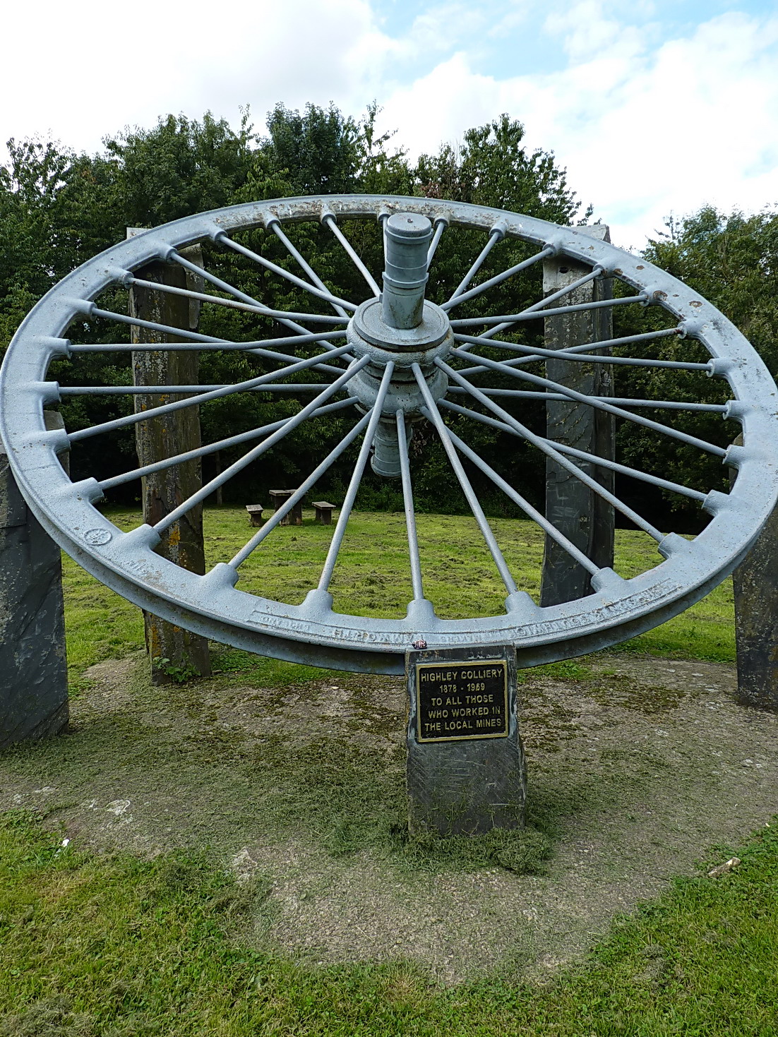
The colliery sidings site is now The Engine House, the Severn Valley Railway’s visitor centre and museum at Highley, where an LNER mineral wagon painted in Highley Mining Company livery is normally on display. A winding wheel from the colliery stands as a memorial.
A colliery winding wheel, and the graded formation of the standard-gauge incline down to the former sidings. The village’s red-brick miners’ terraces are the largest surviving trace.
Related mines
- Alveley Colliery — One mine in two halves. Highley’s workings ran east under the River Severn; the Alveley shaft was sunk in 1935 to meet them, the two joined underground in 1937, and men and equipment were transferred across. Highley’s shaft then served only for ventilation and escape.
- Kinlet Colliery — Both were Highley Mining Company pits. The company prospected in Kinlet parish from the early 1890s and struck coal there in 1894; in 1914 it employed 391 men at Highley and 306 at Kinlet.
Nearby mines
- Alveley Colliery — 0.5 miles (0.8 km) NE
- Kinlet Colliery — 1.4 miles (2.3 km) S
- Billingsley Colliery — 1.8 miles (3.0 km) W
- Bayton Colliery — 7.1 miles (11.4 km) SW, Worcestershire
- Mamble Colliery — 8.2 miles (13.2 km) SW, Worcestershire
Straight-line distance, within 9 miles (15 km). Show on the map.
Recorded claims
Individual factual claims, each attached to the source(s) that support it below. Where sources disagree, both are kept.
- The Highley Mining Company was formed in 1877 to mine coal at Highley, founded by a group of north Staffordshire mine owners. They began sinking their main shaft in 1878 and the broach coal was found a little over a year later, at 300 yards depth. 1
- In 1914, 391 men worked at Highley and 306 at Kinlet; the takeover of Billingsley Colliery in 1915 added another 202 to the company’s workforce. 1
- By 1900 about 240 men and boys were employed and sidings had been built alongside the Severn Valley Railway south of Highley Station, on what is now the site of The Engine House. Trucks were filled at the colliery and run down a standard-gauge incline to the sidings; one of the main destinations was the carpet factories of Kidderminster. 2
- The workforce rose to 670 by 1937. As the workings moved under the River Severn towards Alveley a new shaft was opened there; once the two sets of workings had joined in 1937 men and equipment were transferred, and by 1940 Highley Colliery itself had closed, the pithead remaining open for ventilation. 2
- The village of Highley expanded fourfold between 1875 and 1915 to accommodate the miners and developed the amenities of a small town; the period of intense housebuilding gave Highley its distinctive red-brick terraced miners’ houses. 1,3
Photographs & further reading
The four Wyre Forest pits the railway served, with the sidings, inclines and branch lines that connected them, and the year-by-year account of how Highley gave way to Alveley.
View sourceA short history of the company that ran all four pits: its formation, the sinking of Highley, the move into Kinlet and Billingsley, and the workforce figures for each.
View sourceSources
- (secondary) The Highley Mining Company — Discovering Shropshire's History
- (secondary) Collieries served by the Severn Valley Railway — SVR Wiki, Severn Valley Railway
- (secondary) Highley — Wikipedia
- (primary) BGS mine plans catalogue: Highley — British Geological Survey
Record created: 7 September 2026 · Last researched: 7 September 2026