 MineArchive
Goldscope Mine
| Location | Newlands Valley, Cumbria — 54.5562, -3.1975 (exact) |
|---|---|
| Commodities | Copper, Gold, Lead, Silver |
| Type | Metal |
| Worked | 1564–late 19th century |
| Operators | Company of Mines Royal (1564–?) |
Overview
Goldscope, in the Newlands Valley near Keswick, was one of the richest mines worked by the German miners the Crown brought to Cumbria in the 1560s to secure a domestic copper supply — its name a corruption of the miners' own 'Gottes Gab', or God's Gift.
History
Copper ore had likely been worked at outcrop in the Newlands Valley for centuries before serious underground mining began, but the mine's documented history starts in 1564, in the reign of Elizabeth I, when England's war footing made a secure domestic copper supply a matter of national security. The Crown's Company of Mines Royal brought over the Bavarian metallurgist Daniel Hochstetter and a workforce of German miners to develop the Cumbrian orefield; on 28 May 1568 Elizabeth I chartered the Society of Mines Royal as a joint-stock company to formalise the enterprise, which worked mines across Cumberland and ran a smelting works at Brigham, near Keswick. The Crown considered Goldscope's output so strategically important that it requisitioned the mine outright from its owner, Thomas Percy, 7th Earl of Northumberland, and refused to pay him royalties — a dispute that reflected wider tension between the immigrant German workforce and local landowners. The German miners settled locally, and the venture brought lasting social change to the valley alongside its industrial output. In one twelve-year period the mine raised around 5,000 tons of ore, yielding some 22,000 ounces of silver as a by-product of the copper and lead — a silver cup made from Goldscope metal survives on display at Keswick Museum. The mine was reworked long after its Elizabethan heyday and finally closed at the end of the 19th century, not because its ore was exhausted but because the main shaft had gone so deep that pumping the water out became uneconomic.
Geology
Goldscope's ore occurs in copper- and lead-bearing veins in the Lake District's Skiddaw Group and Borrowdale Volcanic rocks — an east-west vein carrying copper and a north-south vein carrying lead, with the copper ore noted by contemporaries as being particularly difficult to smelt.
Geological setting: Hydrothermal Deposits (well documented example), Veins and Lodes (well documented example)
Workings
St George's Level, also called the Grand Level, served both as the main means of access and as part of an ambitious hydraulic engineering scheme: a stream was diverted between valleys through the mountain to drive an underground waterwheel used for pumping and ore dressing, with a dam built on Scope Beck to power the operation. A hand-carved 'coffin level' — so called for its narrow, coffin-shaped cross-section — survives from the earliest 16th-century working, later partly widened to take haulage tracks as the mine expanded.
Closure
The mine closed at the end of the 19th century once pumping the deepened workings free of water stopped being economic, rather than through exhaustion of the ore.
What remains
Substantial surface and underground remains survive, including the wheelpit that housed the pumping waterwheel and the hand-carved coffin level, both accessible from public paths in the Newlands Valley.
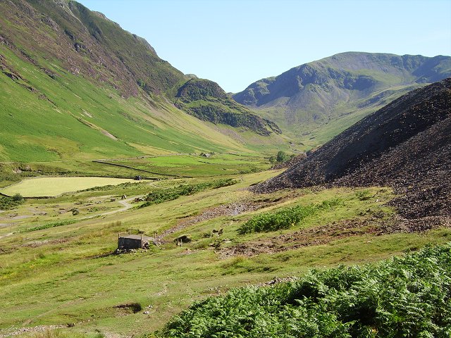
Mine spoil and the remains of the water-power system are visible across the site, part of a valley whose Elizabethan mining history is well documented and locally commemorated.
Related mines
- St Thomas' Work Copper Mine — Both were worked by the Company of Mines Royal in the Newlands Valley from the 1560s, Goldscope being the richest of the company's mines there.
- Yewthwaite Mine — Leased together from 1849 by Clarke, Chapman, Horn and Hart, and Yewthwaite's copper vein is believed to be a continuation of the Goldscope Lode; when Goldscope struck lead in 1853 most of Yewthwaite's men transferred to it.
Nearby mines
- Yewthwaite Mine — 0.9 miles (1.5 km) NE
- Castlenook Mine — 1.1 miles (1.7 km) S
- St Thomas' Work Copper Mine — 1.2 miles (2.0 km) S
- Long Work Copper Mine — 1.5 miles (2.4 km) S
- Brandelhow Mine — 1.6 miles (2.6 km) NE
Straight-line distance, within 9 miles (15 km). Show on the map.
Recorded claims
Individual factual claims, each attached to the source(s) that support it below. Where sources disagree, both are kept.
- In one twelve-year period the mine raised around 5,000 tons of ore, yielding approximately 22,000 ounces of silver as a by-product. 1,2
- The mine worked an east-west vein carrying copper and a north-south vein carrying lead. 1
- A plan and section of Goldscope's main lode at sixty feet to the inch, taking the section down to the 60-fathom level, is held by the British Geological Survey from the Cumbria Amenity Trust's collection (CT183) and can be viewed online, with a ground plan of the lower washing floors and plans of 1861 beside it. 3
Photographs & further reading
The scanned plan and section of the main lode, viewable online.
View sourceThe society's account of the Mines Royal working, its veins and its German miners.
View sourceSources
- (secondary) Goldscope Mine — Northern Mine Research Society
- (secondary) Countrystride #130: Goldscope – The wealth of Newlands — Countrystride / Hefted
- (primary) GOLDSCOPE MAIN LODE (Cumbrian Amenity Trust Historical Mining Society mine plans CT183, BGS mine plans catalogue) — British Geological Survey / Mining Remediation Authority
- (primary) Goldscope Mine Plan (BGS Mine Plans Catalogue, CT183) — British Geological Survey / Cumbrian Amenity Trust Historical Mining Society
Record created: 22 August 2026 · Last researched: 24 September 2026