 MineArchive
Glogfawr Mine
| Also known as | Glog Fawr Mine, Glog-fawr Mine |
|---|---|
| Location | About a mile east-south-east of Ysbyty Ystwyth, near Pont-rhyd-y-groes, Ceredigion — 52.3183, -3.8396 (exact) |
| Commodities | Lead, Silver |
| Type | Metal |
| Worked | Before 1834–1920 |
| Maximum depth | About 110 fathoms (Davey shaft, about 200 m) |
| Operators | John Taylor & Sons (1834–1893) — One of the Lisburne mines the firm took in 1834; chief development from 1860; relinquished 1893. Lisburne Mines Development Syndicate — Took the mine over after the Taylors and sank the Davey shaft; the later working ran from 1907 to 1920. |
Glogfawr is one of the Lisburne group of lead mines, about a mile east-south-east of Ysbyty Ystwyth and 300 yards south of its sister mine Glogfach. John Taylor and Sons developed it between 1860 and 1892, and the Lisburne Mines Development Syndicate reopened it in the 1900s and worked it to 1920. It returned 18,520 tons of lead ore, far more than its low-grade lode might suggest.
Location
Recorded location. The large pin is this mine; the small round markers are the nearest mines on record. Click one for its page. View on full map
History
There were shallow workings at the western end of Glogfawr before 1834, the year the Taylors took the Lisburne mines, and some development followed between 1834 and 1840. The mine's main life began in 1860. Over the next thirty years the engine shaft was sunk vertically to a 20-fathom level and then down the lode to 90 fathoms, and the workings spread along about 520 fathoms of the lode. About 1880 the eastern end was tried from the Penbwlch adit and shaft.
The deep adit of the group, Level Fawr, reached Glogfach about 1872 and was afterwards continued south to Glogfawr, where a winze below the 75-fathom level met it and drained the mine a little deeper than the bottom of the engine shaft. It was never a rich lode. Between 1887 and 1891 the Taylors dressed 30,601 tons of rock for 1,627 tons of ore, roughly a ton in 24, but the ground was soft and cheap to work. They gave the mine up in 1893.
The Lisburne Mines Development Syndicate took it over and sank the Davey shaft near the outcrop, 360 yards north-east of the old engine shaft, to about 20 fathoms below the deep adit, pumping the water up to adit level. This second working lasted from 1907 to 1920, with ore returned from 1909 to 1917. Returns survive for 1862, 1864 to 1893 and 1909 to 1917: 18,520 tons of lead ore in all, yielding 14,218 tons of lead and 64,317 ounces of silver.
Geology
The lode dips north at 55 to 68 degrees in soft crushed mudstones. A great cross-course, 24 to 45 feet wide and running a little east of north, crosses it between the old engine shaft and the Davey shaft and throws it 5 or 6 fathoms to the south on the west side. The cross-course itself carried ore where it met the lode, and the lode was richest and most continuous beside it, especially on the eastern side. The ore body has the shape of a shallow basin, deepest near the Davey shaft, where ore was proved to the 110-fathom level. A second cross-course at the eastern end brought no such enrichment.
Geological setting: Faults and Fractures (well documented example), Veins and Lodes (well documented example)
Workings
Levels are reckoned from an adit cross-cut driven from near the foot of the hill about 130 yards south-east of the engine shaft; a shallower adit to the west follows a north lode. The engine shaft goes down 90 fathoms, the Penbwlch shaft at the eastern end to the 45-fathom level, and the Davey shaft to about 20 fathoms below the deep adit, which here is the 90 or 95-fathom level. The deep adit was driven from Glogfach through the soft ground of the cross-course, which needed heavy timbering and was costly to keep open. Most of the mine yielded 8 to 15 hundredweight of ore to the fathom, and about half the area of the lode held ore worth working, so large blocks were left standing.
Closure
The Taylors gave the mine up in 1893. The later working by the Lisburne Mines Development Syndicate ran from 1907 to 1920; the last return of ore is for 1917.
What remains
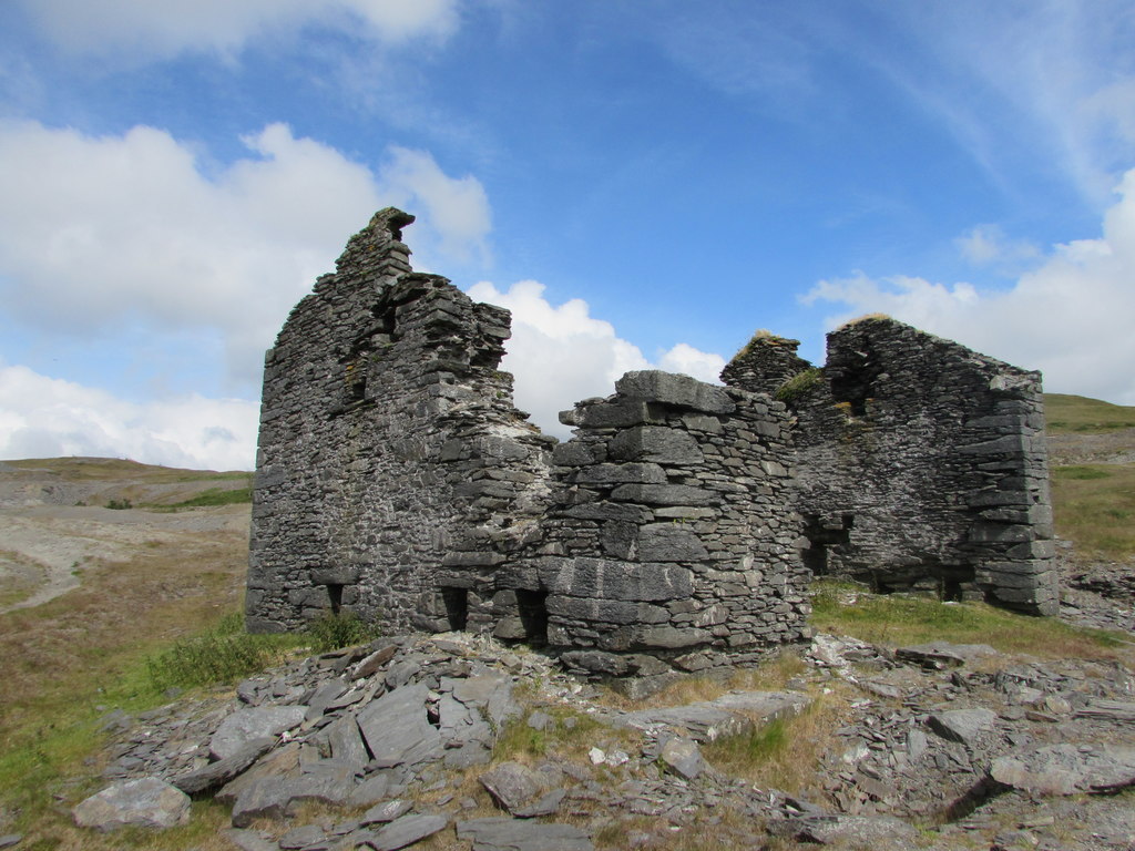
The surface remains run into those of Glogfach and cannot be told apart by function. A roofless crusher house, later reused as a winding house, was standing in 2019.
Traces of tramways and flat-rod lines, two areas of dressing floors, shaft mouths and level entrances with their tips, and large waste heaps. A reservoir fills the hollow along the outcrop of the cross-course, midway between the Davey shaft and the old engine shaft.
Related mines
- Glogfach Mine — The Lisburne group's deep adit, Level Fawr, was driven to Glogfach about 1872 and continued south to Glogfawr, and both were worked by John Taylor and Sons.
- Logaulas Mine — Worked together with Logaulas and Glogfach as the Lisburne mines from 1834.
Nearby mines
- Glogfach Mine — 0.3 miles (0.4 km) N
- Penlanfach Mine — 0.7 miles (1.2 km) SW
- Logaulas Mine — 0.8 miles (1.3 km) NW
- Esgair Mwyn Mine — 0.9 miles (1.5 km) SE
- Hendrefelen Mine — 1.9 miles (3.1 km) W
Straight-line distance, within 9 miles (15 km). Show on the map.
Further reading
The Royal Commission's site record, with photographs of the crusher house, the reservoir and the tips.
View sourceSources
- (primary) Lead and Zinc: The Mining District of North Cardiganshire and West Montgomeryshire (Special Reports on the Mineral Resources of Great Britain, vol. XX), O. T. Jones, 1922 — Memoirs of the Geological Survey
- (primary) Glogfawr Mine; Lisburne Lead & Silver Mines (NPRN 33874) — Coflein, Royal Commission on the Ancient and Historical Monuments of Wales
- (observational) The Old Crushing House, Glog Fawr Mine (photograph, 31 July 2019) — Geograph
- (primary) Mine plan: Glogfawr Mine, SN77SW 6 (KP17014) — British Geological Survey
Record created: 18 November 2026 · Last researched: 18 November 2026