 MineArchive
Glogfach Mine
| Also known as | Glog Fach Mine, Glog-fach Mine |
|---|---|
| Location | Nearly a mile east-south-east of Ysbyty Ystwyth, near Pont-rhyd-y-groes, Ceredigion — 52.3219, -3.8383 (exact) |
| Commodities | Lead, Silver |
| Type | Metal |
| Worked | 18th century–1889 or 1899 |
| Maximum depth | 130 fathoms (Skinner's shaft, about 238 m) |
| Operators | John Taylor & Sons (1834–?) — Taken over in 1834 with the other Lisburne mines; chief development 1854 to 1880. |
Glogfach is one of the Lisburne group of lead mines, a little less than a mile east-south-east of Ysbyty Ystwyth, taken by John Taylor and Sons in 1834. Between 1854 and 1880 they sank Skinner's shaft to 130 fathoms on a soft, rich lode that returned some 9,900 tons of lead ore and a great deal of silver. The ore gave out abruptly at depth, just as the group's deep adit arrived to drain it.
Location
Recorded location. The large pin is this mine; the small round markers are the nearest mines on record. Click one for its page. View on full map
History
The mine was at work in the eighteenth century, and one bunch of ore had been followed to about 50 fathoms from the surface before John Taylor and Sons took it over in 1834 with the other Lisburne mines. It was redeveloped between 1834 and 1840, when 270 tons of ore were raised, and taken up again in the 1850s.
The chief work was done between 1854 and 1880 from two shafts 64 fathoms apart: the engine shaft, sunk to the 48-fathom level, and Skinner's shaft to the west, which reached the 130. In the upper levels the lode was soft and easily mined and the ore compact and pure, yielding a ton or more to the fathom and two and a half to three tons in the 88 and 103-fathom levels, where the ore body was about 140 fathoms long.
Through its best years the mine was drained by pumping. About 1872 the deep adit, Level Fawr, was driven through to the Glogfach workings and drained them to the 118-fathom level, by which time the ground above was practically worked out. The hope was that the lode would be as good below. It was not: the rich ground of the 103 fell away in the 118, and the 130 gave only a few hundredweight to the fathom from hard, narrow ground. Trials east and west of the mine, at Taylor's shaft and beyond Llethr farm, found nothing worth working.
Returns survive for 1838 to 1840, 1858 to 1880 and 1882 to 1889. Since 1845 they come to 9,610 tons of lead ore, yielding 7,392 tons of lead and 132,568 ounces of silver.
Geology
The ore body was roughly lens-shaped, centred in the 88-fathom level about 40 fathoms west of Skinner's shaft, with a narrow westward-dipping tongue reaching the surface between the two shafts. The lode in the upper workings was soft; in the deepest it was hard and only one and a half to four feet wide, with spots and thin strings of ore. To the east the workings ended at the great cross-course also met at Glogfawr, which here was barren, and the lode has never yielded ore beyond it. About 100 fathoms west of Skinner's shaft the lode splits into two or more branches.
Geological setting: Veins and Lodes (well documented example)
Workings
Levels are reckoned from the surface and were driven at 16, 26, 36, 48, 58, 73, 88, 103, 118 and 130 fathoms. The engine shaft goes to the 48, Skinner's shaft to the 130, and a western shaft to the 58 on a north branch of the lode. Water was raised by flat rods until the deep adit, Level Fawr, came in at the 118-fathom level about 1872; the adit was later carried on south to Glogfawr. Half a mile east, Taylor's or East Glogfach shaft was sunk 15 fathoms below an adit on a lode 5 feet wide that held only spots of ore.
Closure
The last return of ore is for 1889, though the mine is also recorded as active until 1899.
What remains
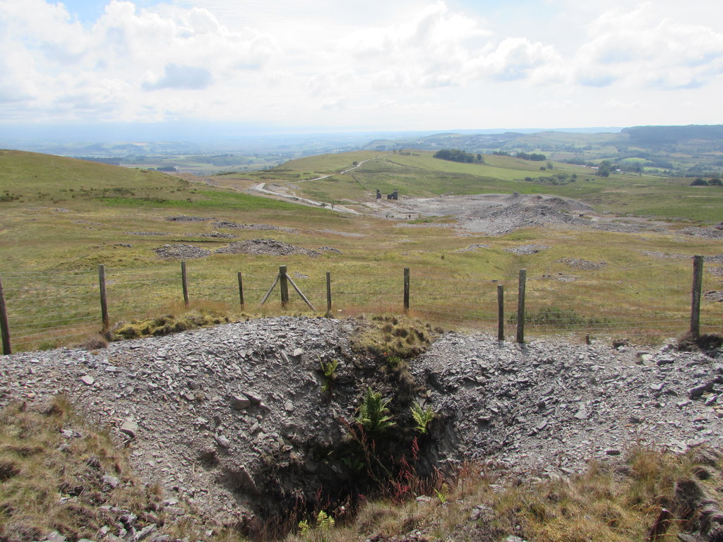
Few surface remains survive, and they merge with those of Glogfawr. The collar of Skinner's shaft was an open, fenced hollow in 2019.
The remains of a crusher house, traces of tramways and leats, and fragments of other structures among the tips.
Related mines
- Glogfawr Mine — The Lisburne group's deep adit, Level Fawr, was driven to Glogfach about 1872 and continued south to Glogfawr, and both were worked by John Taylor and Sons.
- Logaulas Mine — Redeveloped together with Logaulas and Glogfawr as the Lisburne group in 1834-40.
- Penlanfach Mine — Penlanfach was driven in 1877-85 as a trial of the Glogfach lode, and its output was probably returned with Glogfach's.
Nearby mines
- Glogfawr Mine — 0.3 miles (0.4 km) S
- Logaulas Mine — 0.7 miles (1.1 km) NW
- Penlanfach Mine — 0.9 miles (1.5 km) SW
- Esgair Mwyn Mine — 1.1 miles (1.8 km) S
- Hendrefelen Mine — 2.1 miles (3.4 km) W
Straight-line distance, within 9 miles (15 km). Show on the map.
Further reading
The Royal Commission's site record, with photographs of the shafts and the wheelpit.
View sourceSources
- (primary) Lead and Zinc: The Mining District of North Cardiganshire and West Montgomeryshire (Special Reports on the Mineral Resources of Great Britain, vol. XX), O. T. Jones, 1922 — Memoirs of the Geological Survey
- (primary) Glogfach Mine; Lisburne Lead & Silver Mines (NPRN 33873) — Coflein, Royal Commission on the Ancient and Historical Monuments of Wales
- (observational) Skinner's Shaft, Glog Fach Mine (photograph, 1 August 2019) — Geograph
- (primary) Mine plan: Glogfach Mine, SN77SW 5 (KP17013) — British Geological Survey
Record created: 18 November 2026 · Last researched: 18 November 2026