 MineArchive
Gem Mine
| Also known as | West Sortridge Consols, Wheal Grenofen, Walkham Valley Mine, Little Gem, Gem Tin Mine |
|---|---|
| Location | Walkham valley below Grenofen, Horrabridge, Devon — 50.5159, -4.1241 (exact) |
| Commodity | Tin |
| Type | Metal |
| Worked | 1855–1874 |
| Maximum depth | At least 20 fathoms (Lucy's Shaft) |
| Operators | Gem Tin Mining Company (1871–1874), Walkham Valley Tin Mining Company Limited (1880–1881), Walkham United (1881–1883) |
Overview
A small tin mine on the north-east bank of the Walkham below Grenofen, at the end of two medieval openworks, worked as West Sortridge Consols in the 1850s and as Gem Mine from 1871 to 1874, when Lucy's Engine Shaft and the Elizabeth Wheel were christened with bread, cheese and strong beer; absorbed into Walkham United in 1881, and its shaft later filled with the stone of Brunel's demolished viaduct.
History
Gem Mine lies on the north-east bank of the River Walkham below Grenofen, at the western end of two long parallel late-medieval openworks that begin in Birchcleave Wood and cross the Tavistock road by Gem Cottage, the old count house. The openworks exposed the tin lodes, and the first modern attempt on them was probably the Wheal Grenofen that Lysons recorded in Whitchurch parish in 1822 as already abandoned. By 1855 the sett was at work as West Sortridge Consols, listed in 1856 with J. H. Murchison of Bishopsgate as secretary; it returned six tons of tin worth £632, its only recorded output, and was still so named in 1859.
It reopened in 1871 as Gem Mine, from 1873 the Gem Tin Mining Company, under the managing director J. Legassick and the resident agent Captain Unsworth. On Saturday 20 May 1871 a company from Plymouth watched the new engine wheel started with its flat-rods to the engine shaft, which was christened Lucy's Engine Shaft after a young lady present, the wheel being named the Elizabeth Wheel; the mine bell then called everyone to bread and cheese and strong beer. By June the water was in fork nearly to the bottom of the shaft, with ten fathoms of pumps and tin ground opened on the south lode worth over £20 a fathom and on the north lode, three feet wide, at the 14-fathom level. Lucy's Shaft was vertical and met the north lode at 20 fathoms. The mine returned 31 tons of tin worth £2,383 to 1874, when a petition to wind up the company was heard at Truro and the liquidator advertised the plant: a 19-foot water-wheel of six-foot breast with two 14-head stamps, a small wheel, 24 fathoms of five-inch drawing lift, 425 fathoms of rails, 50 fathoms of flat-rods, buddles and dressing floors.
In January 1880 the Mining Journal reported the rich little sett under the Grenofen viaduct acquired by the Walkham Valley Tin Mining Company Limited, and in 1881 it was absorbed into Walkham United, which was struck from the register in 1883. Brunel's Walkham viaduct of 1856 to 1859 passed over the dressing floors, which lay south-west of it with three waterwheels, the middle one driving the stamps; when the viaduct was demolished in 1965 its stone was used to fill the mine shaft.
Geology
Two east-west tin lodes, a north lode three feet wide and a south lode, exposed by two parallel medieval openworks in the killas of the Walkham valley on the western edge of the Dartmoor granite.
Geological setting: Veins and Lodes (historical documentary reference)
Workings
Lucy's Engine Shaft, vertical to the north lode at 20 fathoms and driven 25 fathoms east to rise to the 10-fathom level, with Shallow and Deep adits near it; levels at 10 and 14 fathoms; a tramway from the shaft to the dressing floors by the river, which had three waterwheels, the middle one driving two 14-head stamps.
Closure
The Gem Tin Mining Company was wound up in 1874 and its plant sold; the Walkham Valley company of 1880 and Walkham United of 1881 lasted until the latter was struck off in 1883.
What remains
The shaft was filled with the stone of the demolished viaduct in 1965; the openworks, two wheelpits, a tramway with rails, a sealed adit of 1973 and the leat survive by the river.
Two wheelpits and a ruined building on the dressing floor west of the viaduct site, the tramway bed, the openworks above the road, and Gem Cottage, the former count house.
Redevelopment
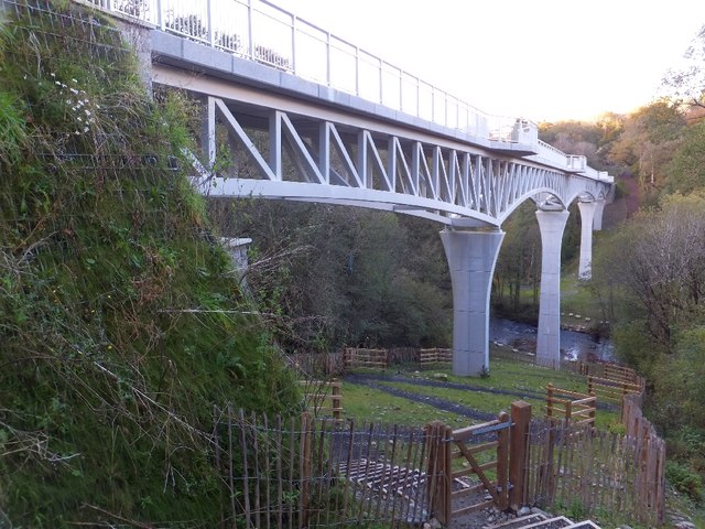
Gem Bridge, opened in 2012 on the viaduct site, carries Drake's Trail over the valley.
Nearby mines
- Westdown Mine — 0.5 miles (0.7 km) W
- Sortridge Consols — 0.9 miles (1.5 km) E
- Great and East Sortridge Consols — 1.4 miles (2.2 km) NE
- North Wheal Robert — 1.5 miles (2.4 km) E
- Wheal Betsy — 2.3 miles (3.6 km) N
Straight-line distance, within 9 miles (15 km). Show on the map.
What's uncertain
Points where sources disagree or the record could not be settled; both accounts are kept. All open questions in the archive.
- The sett may be the Wheal Grenofen that Lysons recorded in Whitchurch parish in 1822 as abandoned since 1815. (uncertain) 1
Recorded claims
Individual factual claims, each attached to the source(s) that support it below. Where sources disagree, both are kept.
- The mine lies at the western end of two parallel late-medieval openworks that begin in Birchcleave Wood. 1
- The sett may be the Wheal Grenofen that Lysons recorded in Whitchurch parish in 1822 as abandoned since 1815. (uncertain) 1
- As West Sortridge Consols in 1855 the mine returned six tons of tin worth £632, its only recorded output under that name. 1
- West Sortridge Consols Copper and Tin Mines, Whitchurch, had J. H. Murchison of 117 Bishopsgate Street as secretary in 1856. 2
- On 20 May 1871 the new engine wheel was started and the engine shaft christened Lucy's Engine Shaft and the wheel the Elizabeth Wheel, under managing director J. Legassick and agent Captain Unsworth. 3
- In June 1871 the south lode at the 14-fathom level was worth over £20 a fathom in places and the north lode, three feet wide, £10 to £20. 3
- Gem Mine produced 31 tons of tin to 1874, valued at £2,383. 1
- Lucy's Shaft was vertical, met the north lode at 20 fathoms and was driven 25 fathoms east to rise to the 10-fathom level. 1
- A petition to wind up the Gem Tin Mining Company was heard in 1874 and the liquidator advertised the plant, including a 19-foot water-wheel with two 14-head stamps, in September 1874. 1,3
- In January 1880 the sett was acquired by the Walkham Valley Tin Mining Company Limited, and in 1881 it was absorbed into Walkham United, struck off in 1883. 1,3
- When Brunel's Walkham viaduct was demolished in 1965 its stone was used to fill the mine shaft. 1
- Gem Bridge, opened in 2012 for Drake's Trail, stands on the site of the Walkham viaduct. 4
Photographs & further reading
A walk over the mine with the openworks, Lucy's Shaft, the tramway, adits and wheelpits located by grid reference, and extracts from Dines and the 1880 Mining Journal.
View sourceTranscriptions of the Tavistock Gazette, London Gazette and Western Morning News reports on the mine.
View sourceSources
- (secondary) Gem Mine (aka West Sortridge Consols) — Dartmoor Explorations
- (secondary) 1856 Mines in Devon and Cornwall — Grace's Guide
- (secondary) Gem Tin Mine: newspaper articles 1871-1881 (transcriptions) — Dartmoor Explorations
- (observational) Gem Bridge over the River Walkham (photograph, 2012) — Geograph
Record created: 18 October 2026 · Last researched: 21 October 2026