 MineArchive
Emma Colliery
| Also known as | Townley Main Colliery, Towneley Emma Colliery |
|---|---|
| Location | Crawcrook, Ryton, Tyne and Wear — 54.9697, -1.7750 (approximate) |
| Commodity | Coal |
| Type | Coal |
| Worked | 1845 (sinking begun)–19 April 1968 |
| Maximum depth | 83 fathoms (498 feet) |
| Operators | Stella Coal Company (?–1946), National Coal Board (1947–1968) |
Overview
A Stella Coal Company colliery near Crawcrook, begun as the Emma Pit of Towneley Colliery in 1845 and worked to 1968, with an 83 fathom shaft, a peak of 952 men in 1925 and a workmen's memorial hall of 1923.
History
Emma Colliery, half a mile south-west of Ryton village near Crawcrook, began as the Emma Pit of Towneley Colliery, the name Towneley Main having earlier belonged to Stargate. Sinking started on 17 March 1845, the shaft being put down below the Brockwell seam, although Whellan's directory of 1894 says it was sunk in 1843. The Stella Coal Company owned it from the 1850s, and the shafts included the Emma, 83 fathoms deep. A staple sunk in 1850 linked the Five Quarter workings to the Brockwell, and a boring from the Towneley seam proved the Tilley to the north-east.
On 8 July 1870 a gas explosion killed two young putters. The colliery produced 550 tons a day in 1894, when it employed 417 people; employment peaked at 952 in 1925 and stood at 829 in 1935, and output in 1947 was 127,118 tons, the year the National Coal Board took over. Its seams were abandoned one after another from 1962, the Brockwell in 1964-66 and the last, the Ruler and Crow Coal, in 1968, and the colliery closed on 19 April 1968 with 186 men on the books in 1965.
Geology
Whellan's directory records seams met in the Stargate section including the Main Coal (6 feet, at 8½ fathoms), Ruler (1 foot 10 inches, 32 fathoms), Towneley or Beaumont (4 feet 4½ inches, 51 fathoms), Stone Coal (3 feet 1 inch, 63 fathoms) and Lower Five Quarter (3 feet 7 inches, 68 fathoms).
Workings
Two shafts were sunk, the Emma being the deeper at 83 fathoms. The 1850 staple joined the Five Quarter and Brockwell workings. Coal went for coking and gas. Seams were abandoned in turn: the Tilley and Five Quarter in 1962, the Three Quarter in 1962-66, the Hutton in 1963, the Brockwell in 1964-66, the Harvey and Top Busty in 1966 and the Ruler and Crow in 1968.
Closure
The colliery closed on 19 April 1968, as its last seams, the Ruler and Crow Coal, were abandoned.
What remains
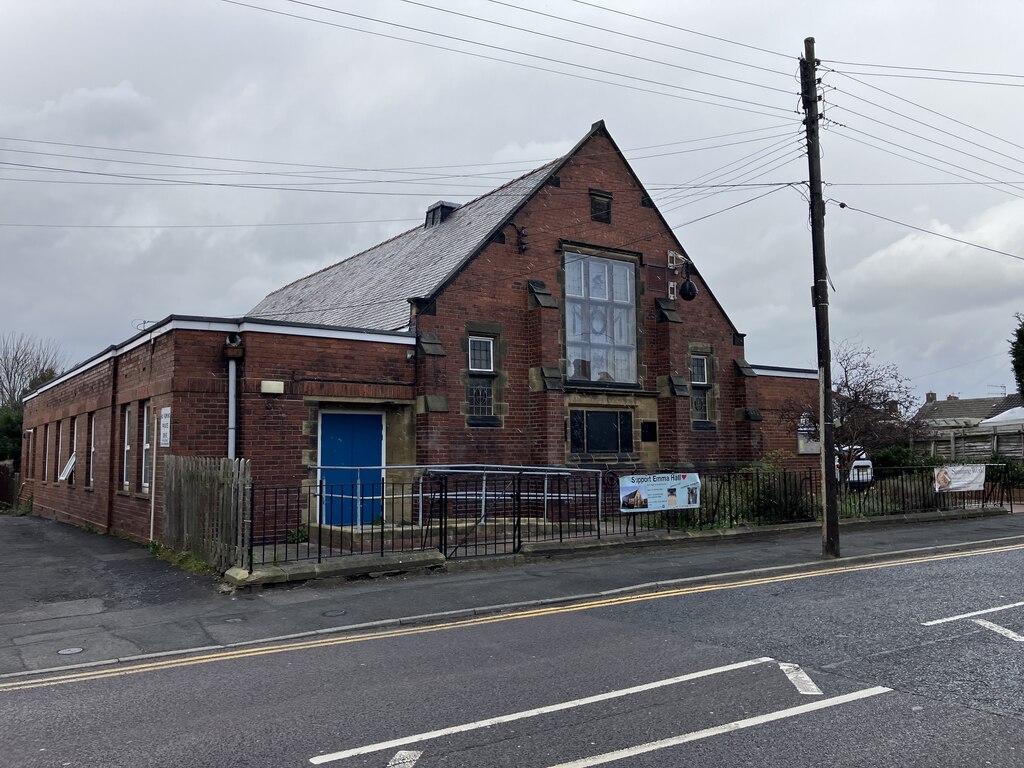
Emmaville Hall, the former Emma Colliery Workmen's Memorial Hall, dated 1923, survives with memorial plaques listing names from both World Wars.
Redevelopment
Unknown.
Related mines
- Stargate Colliery — Both were Stella Coal Company pits on the Townley Main Wagonway; the name Towneley Main passed from Stargate to the Emma Pit.
Nearby mines
- Stargate Colliery — 1.1 miles (1.8 km) E
- Throckley Colliery — 1.3 miles (2.2 km) NE
- Wylam Colliery — 1.4 miles (2.3 km) W, Northumberland
- Blaydon Burn Colliery — 1.7 miles (2.7 km) SE
- Blucher Colliery — 2.5 miles (4.0 km) NE
Straight-line distance, within 9 miles (15 km). Show on the map.
What's uncertain
Points where sources disagree or the record could not be settled; both accounts are kept. All open questions in the archive.
- Whellan's 1894 directory says the Emma pit was sunk in 1843. (disputed) 1
Recorded claims
Individual factual claims, each attached to the source(s) that support it below. Where sources disagree, both are kept.
- Sinking of the Emma Pit began on 17 March 1845, the shaft being put down below the Brockwell seam. 1,2
- Whellan's 1894 directory says the Emma pit was sunk in 1843. (disputed) 1
- The colliery closed on 19 April 1968. 1,2,3
- Owned by the Stella Coal Company from the 1850s and by the National Coal Board from 1947. 1,2
- The colliery produced 550 tons of coal a day in 1894. 2,3
- Employment peaked at 952 in 1925, 765 below ground and 187 on the surface. 1
- A gas explosion on 8 July 1870 killed two putters, George Dobson (18) and Edward Robson (19). 1
- The Emma Colliery Workmen's Memorial Hall was built after 1919 and dated 1923. 4,5
Photographs & further reading
Sinking, owners, output, employment 1894-1965, seam abandonments and a list of those killed.
View sourceThe county Historic Environment Record entry with the dates, owners and 1894 output.
View sourceShort account of the colliery with its 1930 workforce and closure date.
View sourceRecord of the memorial hall and war memorial to the men of Emma Colliery.
View sourceSources
- (primary) Durham Mining Museum - Emma Colliery — Durham Mining Museum
- (primary) Townley Main Colliery (Emma Colliery) (HER 3314) — Tyne and Wear Historic Environment Record (Sitelines)
- (secondary) Emma Colliery (1845-1968) - Co-Curate — Co-Curate (Newcastle University)
- (primary) Bar Moor, B6317, Emma Colliery Workman's Memorial Hall (HER 10836) — Tyne and Wear Historic Environment Record (Sitelines)
- (observational) Emmaville Hall (Geograph 8283565) — Geograph
Record created: 29 September 2026 · Last researched: 29 September 2026