 MineArchive
Earsdon Colliery
| Location | Earsdon, North Tyneside, Tyne and Wear — 55.0414, -1.5147 (approximate) |
|---|---|
| Commodity | Coal |
| Type | Coal |
| Worked | 1823–22 June 1934 |
| Maximum depth | At least 415 feet |
| Operators | Hugh Taylor and William Clark (1823–?), Backworth Collieries Ltd (1910–1934) |
Overview
A Backworth-group colliery at Earsdon, begun with the Duke and Duchess pits of 1823 and 1826 and later the A and Church pits; it employed 829 at its 1924 peak and closed on 22 June 1934.
History
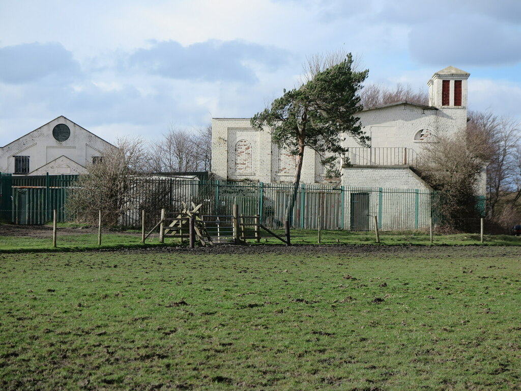
Earsdon Colliery, six miles north-east of Newcastle, began with the Duke and Duchess Pits, 'won' in 1823 and 1826 and owned by Hugh Taylor and William Clark, served by the Backworth Wagonway's East Holywell branch. Their miners lived in farm cottages that became the community of Shiney Row, and by 1897 the pits had gone, replaced by the Abbey Shot Factory. A Pit was sunk from 27 February 1826, and Church Pit from 28 November 1837 and opened in 1838; the Grange Pit followed in 1874. Church Pit, part of Backworth Colliery, closed in 1846 and reopened in 1893. In the 1890s the colliery belonged to the owners of Backworth and West Cramlington collieries, and from the 1910s to Backworth Collieries Ltd. Employment rose from 358 in 1894 to 776 in 1921 and a peak of 829 in 1924, 628 of them underground, and was 418 in 1930. Church Pit's shaft passed the High Main seam, 10 feet 4 inches thick, at 78 feet. The colliery closed on 22 June 1934, when its Main, Yard, Bensham, Low Main and Five Quarter seams were abandoned, though the Historic Environment Record dates the closing of Church Pit to 1933.
Geology
Church Pit passed the High Main seam, 10 feet 4 inches thick with its base at 78 feet 6 inches, the Metal Coal at 149 feet and the Stone Coal at 177 feet, and further seams to a coal 3 feet 6 inches thick at 415 feet 6 inches. The seams abandoned at closure were the Main or Metal, Yard, Bensham, Low Main and Five Quarter.
Workings
The pits were served by the Backworth Wagonway's East Holywell branch. Church Pit was sunk between 25 November 1837 and 29 October 1838.
Closure
The colliery closed on 22 June 1934, when its five remaining seams were abandoned. Its buildings have since been used for light industry and farming.
What remains
Buildings of Church Pit survive at Church Farm and have been used for light industry and agriculture.
Twentieth-century colliery buildings survive at Church Pit, including the pithead baths of 1926, a sub-station and office buildings.
Redevelopment
Church Pit buildings are in light industrial and agricultural use.
Related mines
- Backworth Colliery — Church Pit was part of Backworth Colliery, and the Backworth Collieries group owned Earsdon Colliery from the 1910s.
Nearby mines
- Backworth Colliery — 0.4 miles (0.6 km) W
- East Holywell Colliery — 0.6 miles (1.0 km) N
- Seghill Colliery — 1.8 miles (2.9 km) NW, Northumberland
- Rising Sun Colliery — 2.4 miles (3.8 km) S
- West Moor Colliery — 2.6 miles (4.1 km) W
Straight-line distance, within 9 miles (15 km). Show on the map.
Recorded claims
Individual factual claims, each attached to the source(s) that support it below. Where sources disagree, both are kept.
- The Duke and Duchess Pits were 'won' in 1823 and 1826 and owned by Hugh Taylor and William Clark. 1,2
- A Pit was sunk from 27 February 1826, and Church Pit from 28 November 1837, opening in 1838. 3
- Church Pit closed in 1846, reopened in 1893 and closed again in 1933. 4
- Earsdon Colliery closed on 22 June 1934. 3,2
- Employment peaked at 829 in 1924, 628 of them underground and 201 on the surface. 3,2
- Twentieth-century buildings at Church Pit survive, including the pithead baths of 1926. 4,5
- Church Pit met the High Main seam, 10 feet 4 inches thick, with its base at 78 feet 6 inches. 6
- Earsdon and Church Pit appear in the Coal Authority's combined Backworth-group plans, including one for the Bensham seam abandoned on 5 December 1958. 7
Photographs & further reading
Pits, owners, output, employment 1894-1930, the 1934 abandonments and a short list of those killed.
View sourceThe county Historic Environment Record entry for Church Pit and the buildings that survive.
View sourceRecord of the Duke and Duchess Pits of the 1820s, their owners and the hamlet that grew beside them.
View sourceShort account of the colliery's pits, peak employment and closure.
View sourceSources
- (primary) Earsdon Colliery, Duke and Duchess Pit (HER 1111) — Tyne and Wear Historic Environment Record (Sitelines)
- (secondary) Earsdon Colliery (1823-1934) - Co-Curate — Co-Curate (Newcastle University)
- (primary) Durham Mining Museum - Earsdon Colliery — Durham Mining Museum
- (primary) Earsdon Colliery, Church Pit (HER 1114) — Tyne and Wear Historic Environment Record (Sitelines)
- (observational) Buildings, Church Farm, Earsdon (Geograph 6776370) — Geograph
- (primary) Durham Mining Museum - Earsdon Colliery, Church Pit shaft details — Durham Mining Museum
- (primary) BGS / Mining Remediation Authority abandonment plans: BACKWORTH/EARSDON/CHURCH (Bensham seam) — British Geological Survey
Record created: 29 September 2026 · Last researched: 29 September 2026