 MineArchive
Dunsyston Colliery
| Also known as | Dunsiston Colliery |
|---|---|
| Location | Dunsyston, between Chapelhall and Gartness, south-east of Airdrie, North Lanarkshire — 55.8584, -3.9150 (exact) |
| Commodity | Coal |
| Type | Coal |
| Worked | by 1878–1932 |
| Operators | Summerlee Iron Company (?–1932, owner) — Summerlee Iron Co., Summerlee and Mossend Iron and Steel Co., Summerlee Iron Co., Ltd. (DMM; SMW 1910) |
The Summerlee Iron Company's colliery at Dunsyston, between Chapelhall and Gartness near Airdrie, with its own rows of one-room houses, working the Drumgray coals from the 1870s until 1932.
Location
Recorded location. The large pin is this mine; the small round markers are the nearest mines on record. Click one for its page. View on full map
History
Dunsyston Colliery, also spelled Dunsiston, lay between Chapelhall and Gartness, south-east of Airdrie, and belonged to the Summerlee Iron Company and its successors throughout. It was being sunk by 1879, when a sinker was knocked from his plank by a stone, and a miner had been killed the year before by a splinter of ironstone flying off the face. A plan of No. 2 pit's Upper Drumgray workings dates from 1884. In 1886 a collier was killed by a fifteen-hundredweight stone in No. 1 pit, near Gartness.
The colliery employed 136 in 1894 and 224 in 1910, working the Lower and Upper Drumgray coals. In 1910 the Dunsyston Mine had 183 men underground and 33 on the surface. Only seventeen lived in the company's houses at Dunsyston, twelve one-room and three two-room brick houses built about 1882, with no damp course, no wash-houses and two privy middens in front; the rest lived at Clarkston, Gartness, Chapelhall and Airdrie. A tramway linked the pits. In 1913 an old man crossing the hutch road to No. 5 pit was caught in the moving haulage chain and killed. The Upper Drumgray workings of Nos. 4 and 5 were abandoned in 1916 and the Lower Drumgray in 1932.
Geology
The Lanarkshire coal measures: the Upper and Lower Drumgray coals, with ironstone at the face.
Workings
Several pits, Nos. 1, 2, 4 and 5 among them, linked by a tramway, worked long wall.
Closure
The Upper Drumgray workings of Nos. 4 and 5 were abandoned in 1916 and the Lower Drumgray in 1932.
What remains
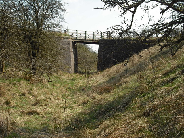
A bridge that carried the tramway between the colliery's pits survives over a cutting.
A tramway bridge between the pits; nineteenth-century miners' rows are recorded at the site.
Nearby mines
- Ardenrigg Colliery — 1.7 miles (2.7 km) NE
- Duntilland Colliery — 2.3 miles (3.8 km) E
- Stanrigg Colliery — 2.4 miles (3.8 km) N
- Faskine Colliery — 2.6 miles (4.1 km) W
- Darngavil Colliery — 3.1 miles (4.9 km) N
Straight-line distance, within 9 miles (15 km). Show on the map.
Further reading
Owners, output, employment and recorded deaths.
View sourceThe 1910 housing report with the Dunsyston Mine and its houses.
View sourceSources
- (primary) Dunsyston Colliery (Durham Mining Museum) — Durham Mining Museum
- (secondary) New Monkland Parish: accidents 1871-1900 (Scottish Mining Website) — Scottish Mining Website
- (primary) Shotts parish housing conditions of miners, 1910 — Scottish Mining Website — Scottish Mining Website
- (secondary) Scottish Mining Website: Lanarkshire accidents 1901-1914 (Airdrie, Calderbank) — Scottish Mining Website
- (observational) Derelict bridge, Jim Smillie (Geograph 1254816) — Geograph
- (primary) Dunsiston Colliery, NRHE 82169 (Canmore / trove.scot) — Historic Environment Scotland (Canmore)
- (primary) BGS mine plan: DUNSYSTON NO 2, Upper Drumgray, abandoned 1884 — British Geological Survey
- (primary) BGS mine plan: DUNSYSTON, Lower Drumgray, abandoned 1932 — British Geological Survey
Record created: 5 November 2026 · Last researched: 8 November 2026