 MineArchive
Stanrigg Colliery
| Also known as | Stanrigg and Arbuckle Colliery, Arbuckle Pit |
|---|---|
| Location | Near Plains, New Monkland parish, about four miles from Airdrie, North Lanarkshire — 55.8922, -3.9274 (approximate) |
| Commodity | Coal |
| Type | Coal |
| Worked | to 1918 |
| Maximum depth | 126 feet (Virgin seam) |
| Operators | McCracken Brothers (?–1918) |
Overview
McCracken Brothers' colliery in Monkland parish near Plains, four miles from Airdrie, working shallow seams under a peat moss through the Arbuckle and Stanrigg pits. On 9 July 1918 liquid moss burst into the workings; 58 men escaped, but nineteen men and boys were entombed, eleven of whom were never recovered.
History
Stanrigg and Arbuckle Colliery lay in the parish of New Monkland, about four miles from Airdrie and a kilometre north of Plains, on high moorland where the coal lay under a peat moss. The lands of Stanrigg had been worked for blackband ironstone and coal in the nineteenth century. By 1918 the colliery belonged to L. and A. McCracken, trading as McCracken Brothers, and had three shafts: the Arbuckle No. 2 upcast, a downcast, and the Stanrigg No. 3, which wound men, materials and coal; an electric fan at the downcast sent 14,100 cubic feet of air a minute through the mine. George Johnstone had managed it since 1915, and it worked a single day shift.
Three seams were worked, the Humph at 82 feet, the Splint at 117 feet and the Virgin at 126 feet, whose upper leaf was called the Sour Milk. Boreholes in October 1916 found moss, mud and clay at various depths. The Humph had been worked by stoop and room, then by longwall with coal cutters, then by stoop and room again because longwall cost too much, and a small fault lay near where the longwall face had stopped.
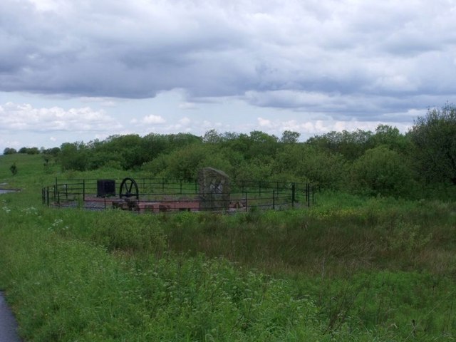
On the morning of 9 July 1918 the bottomer reported that the ventilating current was 'coming very strong'. Liquid moss had broken into the Humph workings and was flowing along the haulage roads. The firemen brought 58 men and boys out by the No. 2 shaft, but the nineteen in the Humph section were cut off; eight bodies were recovered and eleven remain entombed (see Disasters, below). The inquiry found that the manager's change of working method had been an error of judgement. A memorial of standing stones now marks the site.
Geology
Shallow coals under a peat moss with blue clay between: the Humph at 82 feet, the Splint at 117 feet and the Virgin at 126 feet; boreholes in 1916 found moss, mud and clay at various depths, and a small upthrow fault crossed the Humph workings.
Workings
Three shafts (Arbuckle No. 2 upcast, a downcast and Stanrigg No. 3 for winding), a forcing fan at the downcast, and stoop and room and longwall workings in the Humph and Virgin seams joined by stone mines.
Closure
Wrecked by the moss inrush of 9 July 1918, which filled the workings and rose to within 34 feet of the top of the No. 3 shaft; whether the mine would reopen was referred to a committee under the Divisional Inspector.
What remains
The Stanrigg Memorial stands about 100 metres from the site on open moorland: a path to a ring of nineteen small stones round a large inscribed stone.
Redevelopment
Moorland, later worked by opencast; the Stanrigg Memorial.
Nearby mines
- Boglea Colliery — 1.2 miles (1.9 km) N
- Ardenrigg Colliery — 2.5 miles (4.0 km) SE
- Lochend Colliery — 3.3 miles (5.4 km) E
- Duntilland Colliery — 4.5 miles (7.2 km) SE
- Glenboig Fireclay Mines — 4.5 miles (7.2 km) W
Straight-line distance, within 9 miles (15 km). Show on the map.
Disasters & major incidents
-
Stanrigg Colliery inrush, 1918
9 July 1918 · Flooding / Inundation · 19 fatalities
Between ten and half past ten on the morning of 9 July 1918 liquid peat moss broke through into the shallow Humph seam workings of McCracken Brothers' Stanrigg and Arbuckle Colliery near Airdrie. Fifty-eight men and boys escaped, but nineteen in the Humph section were cut off. Boreholes found the workings under water by the second day; eight bodies were recovered and eleven remain entombed.
Recorded claims
Individual factual claims, each attached to the source(s) that support it below. Where sources disagree, both are kept.
- Stanrigg and Arbuckle Colliery belonged to McCracken Brothers. 1,2,3
- It had three shafts: the Arbuckle No. 2 upcast, a downcast and the Stanrigg No. 3. 1,3
- It worked the Humph at 82 feet and the Virgin at 126 feet under a peat moss. 1
- On 9 July 1918 moss burst into the workings; nineteen died and eleven were never recovered. 1,2,3
- A memorial stands near the site of the pit. 2,3,4
Photographs & further reading
The 1918 disaster, its aftermath and the memorial.
View sourceA summary of the inspector's report on the 1918 inrush, with the names of the dead.
View sourceSources
- (secondary) NMRS: Stanrigg and Arbuckle Colliery Inrush, Airdrie, 1918 — Northern Mine Research Society
- (secondary) Wikipedia: Stanrigg mining accident — Wikipedia
- (secondary) RAILSCOT: Stanrigg Memorial — RAILSCOT
- (observational) Geograph: Stanrigg Memorial — Geograph Britain and Ireland
- (primary) BGS / Mining Remediation Authority mine plan: STANRIGG (Slateyband ironstone, coal; abandoned 1888) — British Geological Survey
- (primary) BGS / Mining Remediation Authority mine plan: STANRIGG NO 6 (Main, abandoned 1967) — British Geological Survey
Record created: 11 October 2026 · Last researched: 11 October 2026