 MineArchive
Cossall Colliery
| Location | Cossall, near Ilkeston, Nottinghamshire — 52.9795, -1.2895 (exact) |
|---|---|
| Commodity | Coal |
| Type | Coal |
| Worked | 1870–November 1966 |
| Maximum depth | Unknown. |
| Operators | Cossall Colliery Company (1880–1947), National Coal Board (1947–1966) |
Overview
A colliery on the Nottinghamshire side of the Erewash a mile east of Ilkeston, worked from about 1870 until November 1966 by the Cossall Colliery Company on a seam, the Kilburn, that most of its neighbours never reached. Coal had been dug in the parish since the thirteenth century. The pit's spoil heap went on burning for years after it shut, and the village above it is the Cossethay of D. H. Lawrence's The Rainbow.
History
Coal working in Cossall parish is documented from the thirteenth century, when colliers were recorded working 'mine of sea coal' near the village in 1283, and workings of the sixteenth century are among the earliest exploitation of the surface and near-surface seams locally. The deep colliery came in the second half of the nineteenth century, on the eastern edge of Ilkeston, and its dating is not agreed: the Historic Environment Record gives the colliery as opened in 1870 and the Lists of Mines as worked from 1871, while the parish's own history says it was sunk in 1878-79 by the Cossall Colliery Company, and the register of deaths at the pit and its earlier workings begins in 1868. The Lists show Lynch and Cadogan as owners in 1875, the Cossall Colliery Co. from 1880 and Cossall Colliery Co. Ltd from 1915, and the company also held Trowell Moor Colliery at Stanton Gate by 1900. Alfred Hewlett, known locally as Colonel Hewlett, became managing director and lived at the Hollies, providing the parish church with free coal for its heating.
Cossall was a Kilburn pit. That seam, deep under most of the Nottinghamshire coalfield, carried the colliery from the 1890s to the First World War, joined by the Furnace Coal by 1910 and the Tupton by 1915, and the coal it raised was sold as household. It employed 530 men in 1894 and 578 in 1900, dipped below 500 before the First World War, and then roughly doubled: the returns give 1,023 men in 1923 and the same figure repeated through 1933, 1937 and 1940. At nationalisation in 1947 it had 660 men and raised 220,000 tons of gas, household and steam coal. Two boys eating their breakfast in an old gateway were killed by a fall of roof in October 1888 (see Disasters, below). The colliery closed in November 1966, and most of its buildings were recorded before demolition, some of them by pupils of Bilborough Grammar School in July 1968. The spoil heap caught fire repeatedly for years afterwards.
Geology
The pit worked the Kilburn seam, one of the deeper coals of the Nottinghamshire and Derbyshire field, throughout its returns from 1894 to 1915, adding the Furnace Coal by 1910 and the Tupton by 1915. The parish sits on the Erewash valley side where the measures come near enough to the surface for the sixteenth-century workings to have taken them from shallow pits, so the colliery worked deep coal beneath ground that had been dug for centuries.
Geological setting: Sedimentary Beds and Seams (well documented example)
Workings
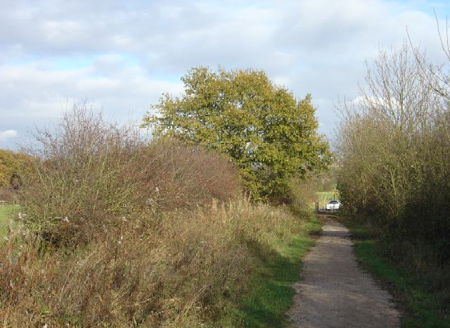
A shaft colliery served by its own railway; a bridleway near Awsworth still follows the course of the colliery line that linked Cossall with the mines in the Strelley area. The inspectors' notes on its fatal accidents show the ordinary working of such a pit: holing under the coal with sprags set, gate ripping shots, trams and pack corners, and old gateways being filled up behind the face.
Closure
Closed in November 1966; the Historic Environment Record gives August as its month for the closure of the colliery site and the parish history November, and both agree on the year. Most of the colliery buildings were recorded before demolition. The spoil heap regularly caught fire for a number of years afterwards, and the slag heap north of the hamlet is still the most visible trace.
What remains
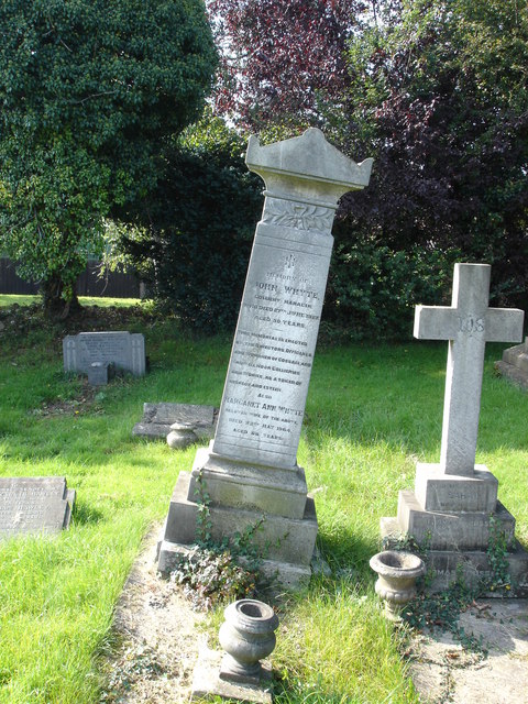
Cleared. Industrial units stand on part of the colliery ground and the slag heap north of the hamlet remains, a bank of waste from the local pits. The former colliery railway survives as a bridleway, and a memorial to John Whyte, colliery manager, put up by the directors and officials of the Cossall and Trowell Moor collieries, stands in the churchyard at nearby Trowell.
The spoil heap, the course of the colliery railway as a bridleway, and the Whyte memorial in the churchyard.
Redevelopment
Industrial units on part of the site; the rest is spoil heap and footpath.
Related mines
- Trowell Moor Colliery — Both worked by the Cossall Colliery Company, which held Trowell Moor from about 1900 and returned the two pits together; the memorial to the colliery manager John Whyte was raised by the directors and officials of the Cossall and Trowell Moor collieries jointly.
Nearby mines
- Awsworth Colliery — 0.9 miles (1.5 km) NW
- Manners Colliery — 1.1 miles (1.8 km) W, Derbyshire
- Rutland Colliery — 1.2 miles (1.9 km) W, Derbyshire
- Oakwell Colliery — 1.3 miles (2.1 km) SW, Derbyshire
- Digby Colliery — 1.5 miles (2.3 km) N
Straight-line distance, within 9 miles (15 km). Show on the map.
Disasters & major incidents
-
Cossall Colliery Roof Fall, 1888
9 October 1888 · Collapse / Roof Fall · 2 fatalities
Two boys, William Green aged fifteen and William Horton aged fourteen, went into an old gateway that was being filled up to eat their breakfast and were killed by a fall of roof. The inquest was held the next day at the Crown Inn, Awsworth.
What's uncertain
Points where sources disagree or the record could not be settled; both accounts are kept. All open questions in the archive.
- The Historic Environment Record gives the colliery as opened in 1870 and closed in 1966. (disputed) 3
- The parish's own history says the colliery was sunk in 1878-79 by the Cossall Colliery Co., while the Lists of Mines record it worked from 1871 and the register of deaths at the pit and its earlier workings begins in 1868. (disputed) 1,4,5
Recorded claims
Individual factual claims, each attached to the source(s) that support it below. Where sources disagree, both are kept.
- Colliers were recorded working 'mine of sea coal' near Cossall by 1283, and coal mining in the parish is documented from the thirteenth century onward, with sixteenth-century workings among the earliest exploitation of the surface and near-surface seams locally. 1,2
- The Historic Environment Record gives the colliery as opened in 1870 and closed in 1966. (disputed) 3
- The parish's own history says the colliery was sunk in 1878-79 by the Cossall Colliery Co., while the Lists of Mines record it worked from 1871 and the register of deaths at the pit and its earlier workings begins in 1868. (disputed) 1,4,5
- The Lists of Mines give Lynch and Cadogan as owners in 1875, the Cossall Colliery Co. from 1880 to 1910 and Cossall Colliery Co. Ltd from 1915 to 1946, with the National Coal Board from 1947. 6,4
- The same company also held Trowell Moor Colliery at Stanton Gate by 1900, and Alfred Hewlett, known locally as Colonel Hewlett, became its managing director and gave the parish church free coal for heating. 7,1
- The colliery worked the Kilburn seam throughout its returns from 1894 to 1915, adding the Furnace Coal by 1910 and the Tupton by 1915, and sold its coal as household. 6
- Employment was 530 in 1894, 578 in 1900, 470 in 1915, 1,023 in 1923 and 660 at nationalisation in 1947, when the pit raised 220,000 tons. 6
- The colliery closed in November 1966 and its spoil heap regularly caught fire for a number of years afterwards. 1
- Most of the colliery buildings were recorded before demolition, some by pupils of Bilborough Grammar School on 1 July 1968. 3
- A bridleway near Awsworth follows the course of the former colliery railway that linked Cossall mine with the mines in the Strelley area, and a slag heap of waste from the local mines stands north of the hamlet. 8,9
- D. H. Lawrence used Cossall as the setting of his 1915 novel The Rainbow, calling it Cossethay; it was the home of Louie Burrows, to whom he was engaged and on whom the character Ursula Brangwen is based, and a plaque on Church Cottage records the association. 1
- The BGS mine-plans catalogue holds a Mining Remediation Authority abandonment plan titled 'Cossall' (catalogue EM862, Low Main Or Tupton, dated 1967). 10
Photographs & further reading
The parish council's account of thirteenth-century coal working, the colliery, Colonel Hewlett and the burning spoil heap, with the Lawrence connection.
View sourceDeaths at the colliery and its earlier workings from 1868, with inquest dates and the inns and institutes where they were held.
View sourceSources
- (secondary) The local history of Cossall Parish (Cossall Parish Council) — Cossall Parish Council
- (secondary) Notts Villages: Cossall (E. Doubleday, Nottinghamshire Guardian) — Nottinghamshire History
- (primary) Nottinghamshire HER monument M2301: Cossall Colliery — Nottinghamshire Historic Environment Record
- (secondary) Buddlepit mine database: Cossall (NMRS list entry) — Buddlepit / Northern Mine Research Society
- (secondary) Cossall Colliery fatalities 1868-1929 (healeyhero.co.uk) — healeyhero.co.uk
- (primary) Durham Mining Museum: Cossall Colliery — Durham Mining Museum
- (primary) Durham Mining Museum: Cossall Colliery Co., Ltd. — Durham Mining Museum
- (secondary) Cossall (Wikipedia) — Wikipedia
- (observational) Bridleway near Awsworth on the course of the Cossall colliery railway (Geograph photograph, 11 November 2007) — Geograph / Alan Murray-Rust
- (primary) BGS / Mining Remediation Authority mine plans: COSSALL — British Geological Survey / Mining Remediation Authority
Record created: 9 September 2026 · Last researched: 9 September 2026