 MineArchive
Chislet Colliery
| Location | Hersden, near Canterbury, Kent — 51.3170, 1.1770 (approximate) |
|---|---|
| Commodity | Coal |
| Type | Coal |
| Worked | From May 1914 (sinking)–1969 |
| Maximum depth | Coal reached at 1,350 ft (411 m) |
| Operators | Anglo-Westphalian Coal Syndicate (1911–1918), Chislet Colliery Ltd (1919–1947), National Coal Board (1947–1969) |
Overview
The westernmost of the Kent coalfield's four collieries, begun by a German-owned syndicate weeks before the First World War broke out, and killed half a century later by the end of steam on the railways — the customer that took most of its coal.
History
German industrialists formed the Anglo-Westphalian Coal Syndicate in 1911 to prospect around Canterbury, and work began near Westbere Court in May 1914. The war made a German-owned colliery in Kent untenable: the German interests were removed and the company was reorganised as North Kent Coalfield Ltd, later Chislet Colliery Ltd. Sinking had to get through waterlogged chalk by the cementation process, and coal was reached at 1,350 ft in 1919. A reorganisation of management in 1929 under E. O. Forster Brown and Charles Clark put the colliery on a sounder footing, and after nationalisation in 1947 it was extensively modernised. It employed 1,550 men at the end.
Geology
Chislet worked the concealed Kent coalfield, where Coal Measures lie buried beneath thick chalk — the reason the sinkers had to consolidate the ground with cement before they could get through it, and the reason every Kent pit was expensive to sink.
Geological setting: Concealed Coalfields (well documented example), Sedimentary Beds and Seams (well documented example)
Workings
Two shafts, sited at the edge of the workable coal rather than over it, so the workings ran out laterally from the shaft bottom — as much as three miles to the south-east. The colliery had its own halt on the railway line beside it for the men.
Closure
Chislet's coal went overwhelmingly to the railways, and when British Rail ended steam haulage in 1968 the market went with it. The colliery closed in 1969, and its 1,550 men transferred to the three remaining Kent pits — Betteshanger, Snowdown and Tilmanstone.
What remains
The colliery was demolished. A small industrial estate occupies part of the site, the waste tip has become a nature reserve, and the village built for the miners survives as Hersden. The Kent Historic Environment Record also notes Second World War defences put up on the colliery ground — gun positions, a pillbox and trenches.
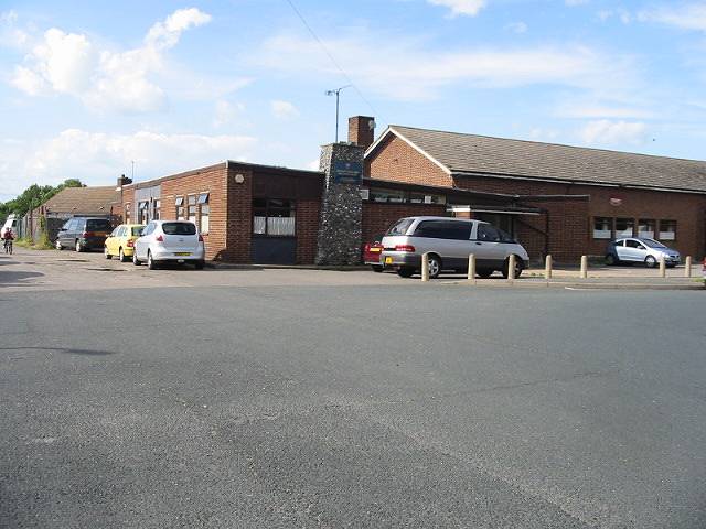
Spoil heaps, the colliery village of Hersden and its Miners’ Welfare Club; the pit itself is gone.
Nearby mines
- Snowdown Colliery — 7.6 miles (12.2 km) S
- Tilmanstone Colliery — 8.7 miles (14.0 km) SE
Straight-line distance, within 9 miles (15 km). Show on the map.
What's uncertain
Points where sources disagree or the record could not be settled; both accounts are kept. All open questions in the archive.
- Coal was reached at 1,350 ft (411 m) in 1919, after the cementation process was used to consolidate the chalk; some accounts date first production to 1918. (uncertain) 1
Recorded claims
Individual factual claims, each attached to the source(s) that support it below. Where sources disagree, both are kept.
- German industrialists formed the Anglo-Westphalian syndicate in 1911 to prospect around Canterbury; work started near Westbere Court in May 1914 and the German interests were removed after war broke out. 1,2
- Coal was reached at 1,350 ft (411 m) in 1919, after the cementation process was used to consolidate the chalk; some accounts date first production to 1918. (uncertain) 1
- The two shafts were sunk at the edge of the workable seams, so the workings ran up to three miles south-east from the shaft bottom. 2
- The Chislet Colliery Housing Society was formed in 1924 to build 300 houses, a village later renamed Hersden to distinguish it from Chislet itself. 1
- The end of steam haulage in 1968 removed most of the colliery’s market; it closed in 1969 and its 1,550 men transferred to the other three Kent pits. 1
- BGS and the Coal Authority hold 26 catalogued mine plans under Chislet; scans exist but are not publicly visible. 3
Photographs & further reading
The museum’s history of the pit, its companies and its village.
View sourceSources
- (secondary) Chislet Colliery — Dover Museum
- (primary) Chislet Colliery (TR 26 SW 75) — Kent Historic Environment Record — Kent County Council
- (primary) BGS mine plans catalogue: Chislet (record 21890261) — British Geological Survey / The Coal Authority
Record created: 25 August 2026 · Last researched: 25 August 2026