 MineArchive
Carberry Colliery
| Location | Inveresk parish, near Musselburgh, East Lothian — 55.9193, -3.0200 (exact) |
|---|---|
| Commodity | Coal |
| Type | Coal |
| Worked | From 1866–1960 |
| Maximum depth | 241 metres. The colliery had two shafts, of 229 and 241 metres; the No. 1 shaft was disused after the No. 3 was sunk in 1900. |
| Operators | Deans and Moore (1866–1900), Edinburgh Collieries Company Limited (1900–1946), National Coal Board (1947–1960) |
Overview
An East Lothian colliery in the parish of Inveresk near Musselburgh, sunk from 1866 by Deans and Moore of Edinburgh and taken over by the Edinburgh Collieries Company in 1900. It had two shafts of 229 and 241 metres, the first falling out of use once the No. 3 was sunk in 1900, and worked the Five Feet, Four Feet, Great Seam and Jewel coals for gas, house and steam coal. Employment ran from 143 in 1894 to a peak of 786 in 1910 and 615 in 1952. It closed in 1960, one of a group of East Lothian pits that went in the same few years, and the site was later a landfill and is now a grassy mound and woodland.
History
Carberry lies in the parish of Inveresk, seven and a half miles east-south-east of Edinburgh and technically within Musselburgh, on the East Lothian coalfield. Sinking and production commenced in 1866 under Deans and Moore of Edinburgh, and the Edinburgh Collieries Company took over in 1900. The colliery had two shafts, 229 and 241 metres deep; the No. 1 fell out of use once the No. 3 shaft was sunk in 1900.
The Lists of Mines show a colliery that changed scale sharply at the turn of the century. It employed 143 in 1894, 139 in 1896 and 1899, and 154 in 1900 — and then 556 in 1905 and 786 in 1910, which is the sinking of the new shaft and the new company's investment showing in the figures. Numbers then move with the century: 529 in 1915, 646 in 1920, 784 in 1923, 497 through the 1930s, 460 in 1947 and 615 in 1954. The average workforce over the life of the colliery is given as 589 and the peak as 615 in 1952. The seams worked in 1905 were the Five Feet, Four Feet, Great Seam and Jewel; the coal was sold as house, gas and steam coal, and in 1947 the output was 142,000 tons, running at about 600 tons a day and 150,000 tons a year in 1948 with 500 employed.
The colliery passed to the National Coal Board in 1947 and closed in 1960. Carberry went at much the same time as Prestongrange and Prestonlinks, the other long-established East Lothian pits, in the round of closures that took most of the county's deep mining in the early 1960s.
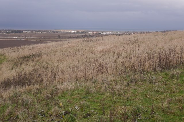
The ground did not stay empty. The colliery site became a landfill tip, and it is now a grass-covered mound with woodland around it; Geograph photographs of 2016 show the mound that covers the site, the access road to what was the tip, and the view out from the top of it.
Geology
Carberry worked the East Lothian coalfield, the eastern limb of the Midlothian basin, whose Coal Measures carry seams named across the Lothians. The seams returned in 1905 are the Five Feet, the Four Feet, the Great Seam and the Jewel; the Jewel is the seam in which the fatal fall of coal of August 1924 happened. The coal suited household, gas and steam use rather than coking.
Geological setting: Sedimentary Beds and Seams (well documented example)
Workings
Two shafts, 229 and 241 metres deep. The No. 3 shaft was sunk in 1900, the year the Edinburgh Collieries Company took over, and the No. 1 went out of use at that point; the jump in employment from 154 in 1900 to 556 in 1905 measures what that reorganisation did to the colliery. Working at the face was in the Jewel and the other named seams, and the Inspector's accounts of accidents here describe falls of coal at the face and the ordinary hazards of the pithead, one man thrown from a scaffold to the railway fourteen feet below by a returning tub in 1903 and a banksman knocked back into the shaft as the cage descended in 1913.
Closure
Carberry closed in 1960, in the same few years as Prestongrange and Prestonlinks, which between them had carried East Lothian's deep coal mining. It was not run down to nothing first: the 1954 return is 615 employed, and the recorded peak workforce is 615 in 1952. No account of the specific closure decision is recorded. The site went on to be used as a landfill tip.
What remains
The colliery site is a grass-covered mound with woodland, having been used as a landfill tip after the pit closed. Geograph photographs from 2016 show the mound that covers the site, the access road to the former tip and the view from the top; one caption notes that before it was pleasant woodland and grassy mound it was the colliery and then the landfill.
None recorded. The colliery was cleared and the ground reshaped first as a tip and then as landscaped mound and woodland, so what is visible is the covering rather than the works.
Redevelopment
The site was used as a landfill after closure and has since been landscaped as a mound with woodland and access roads.
Related mines
- Bellyford Mine — Edinburgh Collieries Company pits in East Lothian.
- Smeaton Colliery — Carberry sent its output to the washery at Smeaton after 1953.
- Wallyford Colliery — Both held by the Edinburgh Collieries Company.
Nearby mines
- Smeaton Colliery — 1.0 miles (1.5 km) SW, Midlothian
- Wallyford Colliery — 1.4 miles (2.2 km) N
- Limeylands Colliery — 1.9 miles (3.0 km) E
- Fordel Mains Colliery — 2.0 miles (3.1 km) S, Midlothian
- Oxenford Colliery — 2.3 miles (3.8 km) SE
Straight-line distance, within 9 miles (15 km). Show on the map.
Disasters & major incidents
-
Carberry Colliery fall of coal, 1924
6 August 1924 · Collapse / Roof Fall · 3 fatalities
On 6 August 1924 three miners were killed by a fall of coal in the Jewel seam at Carberry Colliery, in Midlothian.
Recorded claims
Individual factual claims, each attached to the source(s) that support it below. Where sources disagree, both are kept.
- Sinking and production commenced in 1866 under Deans and Moore of Edinburgh, the Edinburgh Collieries Company took over in 1900, and the colliery closed in 1960. 1
- The colliery had two shafts, 229 and 241 metres deep. The No. 1 shaft was disused after the sinking of the No. 3 shaft in 1900. 1
- Government Lists of Mines record 143 employed in 1894, 154 in 1900, then 556 in 1905 and 786 in 1910; 529 in 1915, 784 in 1923, 497 through the 1930s, 460 in 1947 and 615 in 1954. The average workforce is given as 589 and the peak as 615 in 1952. 2,1
- The seams worked in 1905 were the Five Feet, Four Feet, Great Seam and Jewel, and the coal was sold as house, gas and steam coal. Output was 142,000 tons in 1947, and about 600 tons a day or 150,000 tons a year in 1948 with 500 employed. 2,1
- Carberry closed alongside Prestongrange and Prestonlinks in the early 1960s. 1
- The colliery is recorded in the National Record of the Historic Environment as site 132484, Carberry Colliery, in the parish of Inveresk in East Lothian. 3
- The BGS mine-plans catalogue holds a Mining Remediation Authority abandonment plan titled 'Carberry' (catalogue S331, Four Feet, dated 1960). 4
Photographs & further reading
Location and grid reference, owners from Deans and Moore to the National Coal Board, output and employment by List of Mines year from 1894 to 1954, the seams worked, and twenty-five named dead with the Inspector of Mines' account of each accident.
View sourceThe national monument record entry for the colliery site in Inveresk parish.
View sourceThe county's own statistical account, which gives the colliery's sinking in 1866, its owners, its two shaft depths, the disuse of the No. 1 shaft after 1900, its 1948 output and workforce, its average and peak workforce figures, and its closure in 1960 alongside Prestongrange and Prestonlinks.
View sourceSources
- (secondary) Inveresk: Economy, The Fourth Statistical Account of East Lothian — East Lothian Fourth Statistical Account
- (primary) Carberry Colliery — Durham Mining Museum
- (primary) Carberry Colliery, NRHE 132484 — National Record of the Historic Environment, Historic Environment Scotland
- (primary) BGS / Mining Remediation Authority mine plans: CARBERRY — British Geological Survey / Mining Remediation Authority
Record created: 10 September 2026 · Last researched: 10 September 2026