 MineArchive
Limeylands Colliery
| Location | Ormiston, East Lothian — 55.9125, -2.9734 (exact) |
|---|---|
| Commodity | Coal |
| Type | Coal |
| Worked | by 1915 |
| Maximum depth | Unknown. |
| Operators | Ormiston Coal Co. Ltd (?–1947), National Coal Board (1947–?) |
Overview
Limeylands was the Ormiston Coal Company's pit beside the Bellyford Burn in East Lothian, nine and a half miles east-south-east of Edinburgh. It worked the Four Feet and Five Feet seams and, by 1954, the Nos. 1 and 2 Diamond and the Parrot as well, raising household, manufacturing and steam coal. Employment held remarkably steady for forty years — 199 in 1915, 248 in 1923, 267 in 1947, 315 in 1954 — and it raised 91,000 tons in the National Coal Board's first year. Its ground is now walked as the Pencaitland Railway path.
History
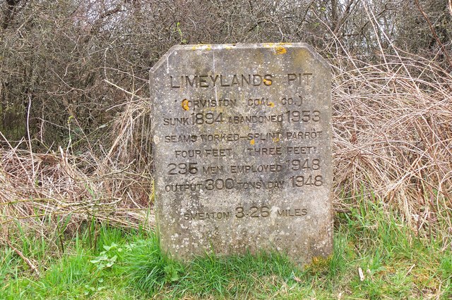
The Ormiston Coal Co. Ltd worked Limeylands through the first half of the twentieth century, and the National Coal Board took it in 1947. The Lists of Mines first return it in 1915 with 199 people, 131 of them below ground, raising household, manufacturing and steam coal from the Four Feet and Five Feet seams. The workforce rose to 273 in 1920 and then settled: 248 in 1923, 240 in 1933, 260 in 1940 and 267 in 1947, when the output was 91,000 tons. The 1954 return is the largest, 315 people, but with an unusual split — only 180 below ground against 135 on the surface — and by then the Nos. 1 and 2 Diamond and the Parrot seams were being worked alongside the Four and Five Feet. Ormiston is one of the East Lothian villages whose modern shape came from coal. The colliery was served by the Pencaitland railway, a mineral line through the East Lothian pits.
Geology
Limeylands worked the Four Feet and Five Feet seams of the East Lothian coalfield, adding the Nos. 1 and 2 Diamond and the Parrot by 1954. The Parrot is a cannel-type coal, rich in oil and gas, worked here alongside ordinary household and steam coals.
Geological setting: Sedimentary Beds and Seams (well documented example)
Workings
A shaft colliery near the Bellyford Burn, connected to the Pencaitland railway. The 1954 return, with 180 people below ground and 135 on the surface, points to substantial surface preparation plant by that date.
Closure
The closure date is not known. The colliery was still returned in 1954 with 315 people, the largest figure in its record, and by then was working four seams. The Pencaitland railway that served the East Lothian pits is now a walking and cycling path.
What remains
The colliery has gone. The Pencaitland Railway Walk and cycle path runs through the site along the old mineral line, and a colliery site is recorded on the ground at Bellyford beside the burn.
The colliery has gone; a colliery site is recorded on the ground at Bellyford beside the burn, and the Pencaitland Railway Walk follows the old mineral line.
Related mines
- Bellyford Mine — Neighbouring Ormiston pits about 200 yards apart; Limeylands' men moved to Bellyford in 1953.
- Ormiston Station Colliery — Ormiston collieries of the Ormiston Coal Company.
- Oxenford Colliery — Ormiston Coal Company pits at Ormiston.
- Smeaton Colliery — Limeylands sent its output to the washery at Smeaton after 1953.
- Tynemount Colliery — Both Ormiston Coal Company pits in the same parish, Limeylands sunk in 1894 and Tynemount thirty years later.
Nearby mines
- Tynemount Colliery — 0.7 miles (1.1 km) SE
- Bellyford Mine — 0.7 miles (1.2 km) E
- Oxenford Colliery — 0.9 miles (1.5 km) S
- Elphingstone Colliery — 1.0 miles (1.6 km) E
- Fleets Colliery — 1.4 miles (2.3 km) NE
Straight-line distance, within 9 miles (15 km). Show on the map.
What's uncertain
Points where sources disagree or the record could not be settled; both accounts are kept. All open questions in the archive.
- The BGS mine-plans catalogue holds a Mining Remediation Authority abandonment plan titled 'Limeylands' (catalogue 9539, Parrot, dated 1928); the catalogue gives no location and the plan's details do not clearly tie it to this working, so it may belong to another of the same name. (uncertain) 2
Recorded claims
Individual factual claims, each attached to the source(s) that support it below. Where sources disagree, both are kept.
- Limeylands was worked by the Ormiston Coal Co. Ltd and passed to the National Coal Board in 1947. 1
- The colliery employed 199 people in 1915, 248 in 1923, 267 in 1947 and 315 in 1954, the last of those with 180 below ground and 135 on the surface. 1
- The Four Feet and Five Feet seams were worked from 1915, with the Nos. 1 and 2 Diamond and the Parrot added by 1954. 1
- The colliery raised 91,000 tons of household, manufacturing and steam coal in 1947. 1
- The BGS mine-plans catalogue holds a Mining Remediation Authority abandonment plan titled 'Limeylands' (catalogue 9539, Parrot, dated 1928); the catalogue gives no location and the plan's details do not clearly tie it to this working, so it may belong to another of the same name. (uncertain) 2
Photographs & further reading
Owners, output, employment and seams for each Lists of Mines year from 1915 to 1954.
View sourceThe East Lothian village the colliery served, its mining history and the Pencaitland railway that ran through the district’s pits.
View sourceSources
- (primary) Durham Mining Museum: Limeylands Colliery — Durham Mining Museum, from the Lists of Mines
- (primary) BGS / Mining Remediation Authority mine plans: LIMEYLANDS — British Geological Survey / Mining Remediation Authority
- (observational) Colliery site, Bellyford, near Ormiston (photographed 2018) — Geograph Britain and Ireland
- (observational) Site of Limeylands Pit, Ormiston (Geograph) — Geograph Britain and Ireland, Jim Barton
- (secondary) Ormiston — Wikipedia
Record created: 10 September 2026 · Last researched: 11 September 2026