 MineArchive
Buckden Gavel Mine
| Also known as | Buckden Gavel Level |
|---|---|
| Location | Buckden Gill, Buckden Pike, Wharfedale, North Yorkshire — 54.1986, -2.0706 (approximate) |
| Commodity | Lead |
| Type | Metal |
| Worked | 1803 or 1804; earlier working from the 1690s–By the 1880s |
| Maximum depth | No depth figure has yet been located. |
| Operators | Robert Higgs and Company (1803–1812), Bernard Lodge (1812–?) |
Overview
A lead mine in the gill on the west flank of Buckden Pike, unusual in Wharfedale for taking most of its ore from pipes and flats in the Main Limestone rather than from veins. A level was driven at the head of Buckden Beck in the first years of the 19th century and worked for some seventy years; the ruined smelt mill just below it had smelted the same ore a hundred years earlier.
History
The ore body was found at its northern end, near Bishopdale, by a mine called Blow Groves in the 1690s, and a small smelt mill was built in the gill in 1698. In the 1740s and 1750s the ore was followed under an increasing thickness of shale and sandstone by sinking ever deeper shafts, but by the last quarter of the century the mine was more or less idle. Robert Higgs and Company then drove a level in at the head of Buckden Gill to work the pipe and flats at their southern end, under the summit of Buckden Pike. Higgs had given up by 1812, when the mine was leased to Bernard Lodge; members of the Lodge and Tennant families worked it for the next seventy years or so, leaving extensive workings with deep sumps in the floor of the level. Ore went first to Birks Mill and then, as production increased, to a new mill built in 1815 at Cam Gill, Starbotton, three kilometres away; later smelting for the district was done at Grassington.
Geology
Buckden Gavel was unique in Wharfedale in that most of its ore came from pipes and flats in the Main Limestone instead of from veins — flats being mineralisation spread sideways along a bedding plane, replacing the limestone. The mine and the earlier smelt mill lie in a narrow, steep-sided gill cut into the west flank of Buckden Pike.
Workings
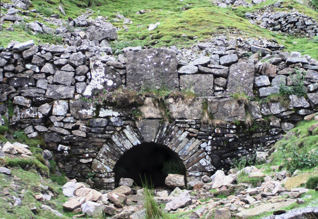
The mine is entered by an adit driven north-east, 1.5 m high with an arched portal 1.3 m across set in a revetment wall 5.6 m wide, the keystone inscribed 'T H'. West of the entrance are the ruins of a lodging shop, the dormitory building for workers who did not live on site, on a terrace cut into the hillside; a small dam and reservoir lie across the stream above the entrance, and washing floors at the mouth of the mine and on a second walled terrace south-west of the shop. Spoil from the mine runs at least 60 m south of the entrance and spills down the sides of the gill. The earlier smelt mill, 5 m below the foot of the tips, is a two-roomed house 11 m by 6 m with walls up to 2 m high: one room held a single ore hearth against the dividing wall and the other probably the bellows, and the absence of a flue shows it vented through a chimney on the roof, the dust chamber in the roof space catching lead from the fume. A flat buddle lies east of the mill.
Closure
The Lodge and Tennant families are recorded as working the mine for about seventy years from 1812, which brings the working life to the early 1880s; no exact closing date has been located, and the mine and the smelt mill below it were never in use at the same time.
What remains
The mine and the earlier smelt mill are a scheduled monument. The adit portal, the lodging shop, the washing floors and the dam survive as earthworks and ruins in the gill; the mill's walls stand to about 2 m. The workings behind the portal are extensive and contain deep sumps in the floor of the level.
The arched adit portal and its revetment, the lodging-shop ruins, two washing floors, a dam and reservoir, spoil heaps running down the gill, and the two-roomed smelt mill with its flat buddle.
Redevelopment
None. The gill is open hillside above Buckden.
Nearby mines
- New Providence Lead Mine — 2.4 km S
- Providence Mine — 3.7 km S
- Fountains Fell Colliery — 10.9 km SW
- Burtersett Flag Stone Mine — 12.1 km NW
- Grassington Moor Mines — 12.5 km SE
Straight-line distance, within 15 km. Show on the map.
What's uncertain
Points where sources disagree or the record could not be settled; both accounts are kept. All open questions in the archive.
- Robert Higgs drove the level in at the head of Buckden Gill in 1803. (disputed) 2
- Robert Higgs and Company began driving the level from the head of Buckden Beck in 1804. (disputed) 1
- The smelt mill in the gill was built in 1698 and worked until the early 1730s, when it was replaced by Birks Mill, built in 1713. (disputed) 2
- The smelt mill above the tips, Buckden High Mill, had a single bellows-blown ore hearth and worked for only about eight years. (disputed) 1
Recorded claims
Individual factual claims, each attached to the source(s) that support it below. Where sources disagree, both are kept.
- Buckden Gavel was unique in Wharfedale in that most of its ore came from pipes and flats in the Main Limestone instead of from veins. 1
- Robert Higgs drove the level in at the head of Buckden Gill in 1803. (disputed) 2
- Robert Higgs and Company began driving the level from the head of Buckden Beck in 1804. (disputed) 1
- Higgs had given up by 1812, when the mine was leased to Bernard Lodge, whose family and the Tennants worked it for the next seventy years or so. 1
- The smelt mill in the gill was built in 1698 and worked until the early 1730s, when it was replaced by Birks Mill, built in 1713. (disputed) 2
- The smelt mill above the tips, Buckden High Mill, had a single bellows-blown ore hearth and worked for only about eight years. (disputed) 1
Photographs & further reading
The Northern Mine Research Society's account of the mine, its pipes and flats, its lessees and the two Buckden smelt mills.
View sourceSources
- (secondary) Buckden Gavel Mine — Northern Mine Research Society
- (primary) Buckden Gavel lead smelt mill and mine, Buckden (List entry 1015905) — Historic England
- (primary) Abandoned mine plan catalogue entry: GAVEL LEAD MINE NEAR BUCKDEN — British Geological Survey
Record created: 22 September 2026 · Last researched: 22 September 2026