 MineArchive
Bradda Head Mines
| Location | Bradda Head, near Port Erin, Isle of Man — 54.0943, -4.7691 (approximate, low confidence) |
|---|---|
| Commodities | Copper, Lead, Silver |
| Type | Metal |
| Worked | Bronze Age–1904 |
| Operators | Bradda Mining Company (1866–1875) |
Overview
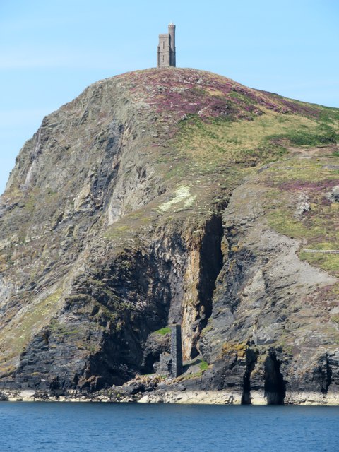
Bradda Head, the headland above Port Erin on the Isle of Man's south-west coast, carries evidence of copper and lead mining spanning from the Bronze Age to the early 20th century, including two distinct workings — South Bradda and North Bradda — whose surface remains are still visible below Milner's Tower.
History
Surface and near-surface extraction of copper ore and lead at Bradda Head dates back to the Bronze Age, with stone mauls associated with prehistoric copper mining recovered near the South Bradda mine. An 1903 geological survey of the Isle of Man describes mining at Bradda as probably the island's most ancient, predating documentary record, with underground working recorded in the 17th century and mining resuming again from around 1850. The South Bradda mine was worked mainly for copper; North Bradda mainly for argentiferous galena — lead ore bearing silver. Milner's Tower, built on the headland in 1871 as a memorial to the safe-maker and philanthropist William Milner, now stands above the old workings as the site's best-known landmark. Mining at Bradda Head finally ceased in 1904.
Geology
The Bradda lode is nearly vertical, with quartz and fault-breccia walls 30 to 50ft wide; a narrow Tertiary olivine-dolerite dyke runs alongside its northern section.
Geological setting: Faults and Fractures (well documented example)
Workings
South Bradda's workings included an adit driven from roughly halfway up the cliff face, a later level extending more than 100 fathoms along the lode near the high-tide mark, and a shaft sunk 30 fathoms from the cliff base. North Bradda's main shaft reached a depth of 72 fathoms, with levels at 27, 40, 50, 60 and 72 fathoms; the mine suffered heavy salt-water inflows of up to 200 gallons a minute.
Closure
Mining at Bradda Head finally ceased in 1904.
What remains
Surviving surface remains include an engine house at the waterline below Milner's Tower, and at North Bradda an engine house with chimney, a smithy, and various adits and shafts on a platform 15-20ft above sea level; remains of the South Bradda mine's captain's house and pump house survive low on the rock face on the southern side, visible from the sea. The volunteer Laxey Mines Research Group, under a memorandum of understanding with the Manx government's DEFA, has been capping shafts and sealing adits here for public safety (work estimated to have saved the government some £1.5m) and is preparing technical drawings for information boards as part of a planned Manx mining heritage trail.
Related mines
- Glenchass Mine — Glenchass was first worked as part of the Bradda mining sett before becoming an independent company.
Nearby mines
- Glenchass Mine — 1.9 miles (3.1 km) SE
- Ballacorkish Mine — 5.0 miles (8.0 km) E
- Langness Mine — 6.3 miles (10.1 km) E
- Foxdale Mines — 7.4 miles (11.9 km) NE
- Glen Rushen Mines — 8.0 miles (12.8 km) NE
Straight-line distance, within 9 miles (15 km). Show on the map.
Recorded claims
Individual factual claims, each attached to the source(s) that support it below. Where sources disagree, both are kept.
- An 1903 geological survey of the Isle of Man describes mining at Bradda as probably the island's most ancient, predating documentary record, with underground working recorded in the 17th century and mining resuming again from around 1850. 1
- North Bradda's main shaft reached a depth of 72 fathoms, with levels at 27, 40, 50, 60 and 72 fathoms; the mine suffered heavy salt-water inflows of up to 200 gallons a minute. 1
- South Bradda's workings included an adit driven from roughly halfway up the cliff face, a later level extending more than 100 fathoms along the lode near the high-tide mark, and a shaft sunk 30 fathoms from the cliff base. 1
- Stone mauls associated with prehistoric copper mining have been recovered near the South Bradda mine. 2
- The volunteer Laxey Mines Research Group, working under a memorandum of understanding with DEFA, has capped shafts and sealed adits at Bradda Head for public safety, and is preparing technical drawings of the mine workings for information boards planned as part of a Manx mining heritage trail. 3
- The Bradda Mining Company resumed operations at Bradda Head between 1866 and 1875. 4
Photographs & further reading
A 2020s feature on the Laxey Mines Research Group's ongoing conservation work at North Bradda.
View sourceSources
- (primary) Geology of the Isle of Man (Chapter 12) — G.W. Lamplugh, HMSO, 1903
- (secondary) Bradda Head — Wikipedia
- (secondary) Inside the mine where 'darkness beckons' — Isle of Man Today
- (secondary) South Bradda Mine (Minehough) — Mindat
Record created: 19 August 2026 · Last researched: 31 August 2026