 MineArchive
Langness Mine
| Location | Langness peninsula, near Castletown, Isle of Man — 54.0700, -4.6200 (approximate) |
|---|---|
| Commodity | Copper |
| Type | Metal |
| Worked | 19th century–1902 |
| Maximum depth | 40 fathoms (about 240 ft). |
| Operators | Langness Copper Co. Ltd. |
Overview
Langness Mine worked copper on the long, low peninsula that runs south from Castletown to Dreswick Point, the southernmost tip of the Isle of Man. The ore outcrops in the cliffs there, which is why the ground is among the earliest known mining sites on the Island; the nineteenth-century working went down forty fathoms and had its own smithy, changing rooms and crushing floor. The 1902 List of Mines records it under the Langness Copper Company with six men underground, and notes it as standing.
History
Langness means Long Point, and its southernmost tip, Dreswick Point, is the southernmost point of the Isle of Man. The promontory has carried a great deal of history besides mining: shipwrecks, gun batteries and several fortifications, the first Derby horse race in the eighteenth century, and more recently a golf course and a hotel.
Mining for metals on the Island probably began as early as the Bronze Age, and Langness is one of the sites identified with that earliest working, together with Bradda Head — in both places the ore could be seen outcropping in the cliffs, which is the usual reason an ancient working is where it is.
The nineteenth-century mine is the one the record describes. The 1902 List of Mines under the Metalliferous Mines Act enters it as Langness, at Castletown, worked for copper ore by the Langness Copper Co. Ltd. of 29 Gracechurch Street in London, with J. Lace as agent and six men employed underground. The remark against the entry is "Standing" — the return's own word for a mine not then being worked.
What the site held is still legible. By the car park at the neck of the peninsula are the remains of a small building marking the spot of the mine, where there was a smithy and changing rooms for the miners. The mine went down forty fathoms, about 240 feet. The ore was crushed by machines bedded on concrete blocks that can still be seen nearby, and it was hoisted from underground by machinery housed in the main building.
Geology
The southern end of the Island around Castletown and Langness exposes Carboniferous rocks — a limestone sequence including the Castletown and Poyllvaaish Limestones, underlain by the Carboniferous Basement Conglomerate resting in turn on the Manx Slates. The copper here is chalcopyrite, and the Geological Survey's memoir of 1903 notes that the copper pyrites of Langness are associated with olivine-dolerite dykes, probably of Tertiary age. That association matters: across the Island the same memoir records a long argument among miners about whether such dykes cut out and spoiled the lodes they crossed, an opinion the Survey came to doubt, partly on the evidence obtained at Langness itself.
Geological setting: Faults and Fractures (well documented example)
Workings
A shaft to forty fathoms, about 240 feet, with the ore hoisted by machinery in the main building at surface and crushed by machines bedded on concrete blocks alongside. There was a smithy on site and changing rooms for the miners. Nothing on record describes the underground layout, the number of levels, or how far the workings ran under the peninsula.
Closure
The closure date is not known. The 1902 return records the mine as standing — held but not being worked — with six men underground, which is the last position this record can document. Manx metal mining as a whole did not survive far into the twentieth century.
What remains
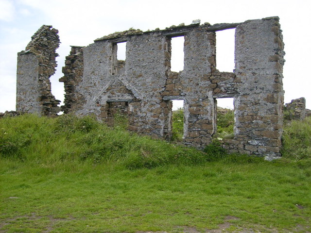
Remains survive above ground at the neck of the peninsula. Beside the car park stands the ruin of a small building marking the site of the mine, and the concrete blocks on which the crushing machinery was bedded are still visible nearby. Buildings on the peninsula believed to have served the mine have been photographed, one of them partially restored.
The remains of a small building at the mine site, which held the smithy and the miners' changing rooms, and the concrete blocks that carried the ore-crushing machinery. Further buildings on the peninsula are believed to be associated with the working, one partially restored.
Nearby mines
- Ballacorkish Mine — 2.2 miles (3.5 km) NW
- Glenchass Mine — 4.7 miles (7.5 km) W
- Bradda Head Mines — 6.3 miles (10.1 km) W
- Foxdale Mines — 6.9 miles (11.1 km) N
- Douglas Head Mine — 7.6 miles (12.3 km) NE
Straight-line distance, within 9 miles (15 km). Show on the map.
What's uncertain
Points where sources disagree or the record could not be settled; both accounts are kept. All open questions in the archive.
- Mining for metals on the Isle of Man probably began as early as the Bronze Age, with early sites identified at Langness and Bradda Head, where copper could be seen outcropping in the cliffs. (uncertain) 2
Recorded claims
Individual factual claims, each attached to the source(s) that support it below. Where sources disagree, both are kept.
- The 1902 List of Mines records Langness at Castletown, worked for copper ore by the Langness Copper Co. Ltd. of 29 Gracechurch Street, London, with J. Lace as agent, six men employed underground, and the remark 'Standing'. 1
- The mine went down 40 fathoms (240 ft); the ore was crushed by machines bedded on concrete blocks which can still be seen nearby, and was hoisted from underground by machinery in the main building, with a smithy and changing rooms for the miners on site. 2
- Mining for metals on the Isle of Man probably began as early as the Bronze Age, with early sites identified at Langness and Bradda Head, where copper could be seen outcropping in the cliffs. (uncertain) 2
- The copper pyrites of Langness are associated with olivine-dolerite dykes, probably of Tertiary age; evidence obtained at Langness contributed to the Geological Survey abandoning the miners' view that such dykes cut out and spoiled the lodes they crossed. 3
- The remains of a small building beside the car park mark the spot of the Langness copper mine, where there was a smithy and changing rooms for the miners. 2
Photographs & further reading
The Manx cultural foundation's guide to the peninsula, which walks past the mine and describes what survives of it — the building, the crushing blocks, the depth of the shaft — alongside the rest of Langness's history.
View sourceSources
- (primary) 1902 List of Mines under the Metalliferous Mines Act: Isle of Man — Durham Mining Museum
- (secondary) Langness — Culture Vannin
- (primary) Geology of the Isle of Man (Chapter 12) — G.W. Lamplugh, HMSO, 1903
Record created: 5 September 2026 · Last researched: 5 September 2026