 MineArchive
Beldon Lead Mine
| Also known as | Beldon Mine, Beldon Shields Mine |
|---|---|
| Location | Beldon Shields, Hunstanworth, County Durham — 54.8406, -2.1127 (approximate) |
| Commodities | Lead, Fluorspar |
| Type | Metal |
| Worked | 18th century–By 1820 |
| Maximum depth | Unknown. The extent of the underground workings is unclear. |
Overview
A lead mine and ore works on two levels of the narrow Beldon Burn above Blanchland, opened in the 18th century, enlarged in 1805 with what is thought to have been a Boulton and Watt engine, and closed by 1820 before a second working in the 1860s and 1870s. Fluorspar trials were made on the dumps in 1924 but came to nothing.
History
Lead mining in the Blanchland, Edmondbyers and Healeyfield part of the Derwent valley goes back to medieval workings, the mines being reckoned silver producers in the 15th century and worked on and off for lead for five hundred years afterwards; successive operators failed to put in enough capital, and the high costs of working and maintenance brought the Derwent lead industry down for good in 1883. Beldon worked a number of small veins — Standalone, Fellgrove, Shildon, Old Shildon, Garden, Sluice, Gin o' the Wood and Andrew's among them — though the extent of the underground workings is unclear. The visible remains belong to two periods: the first from the 18th century, when the mine opened, to its closure by 1820, with an enlargement in 1805 when it is thought a Boulton and Watt steam engine was installed; the second a reworking of the mine and ore works in the 1860s and 1870s. Surface trials for fluorspar were made on the ground in 1924, but no further work followed, and vein material is still abundant on the dumps.
Geology
The mine worked a group of small lead veins in the Carboniferous rocks of the Derwent valley, on the northern edge of the Northern Pennine orefield. Fluorite is plentiful in the veinstuff on the dumps, which is what drew the fluorspar prospectors of the 1920s.
Workings
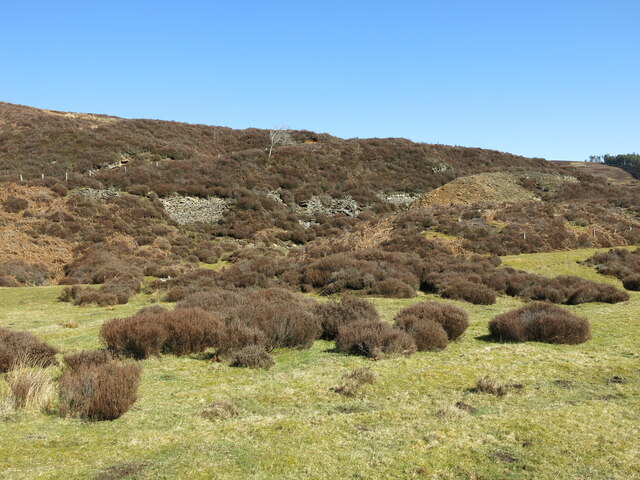
The mine and its ore works stand on two levels on the floor of the narrow Beldon Burn. Two stone-lined shafts, both thought to belong to the first phase, gave access: one at the north-west corner of the site is 10 m square, its upper parts showing as lengths of rubble walling half buried in spoil, and a roughly circular, water-filled shaft lies 20 m south beyond a line of spoil heaps. An adit immediately south-east of the circular shaft survives as two parallel rubble walls 2 m high with its stone portal buried under rubble, and further ruined structures east of it are thought to be bouse teams. Attached to the south side of the circular shaft are the remains of the engine house, its lower courses standing up to 3 m high and 8 m wide, filled with its own collapsed upper walls; 30 m east is a two-roomed building 12 m by 6 m with an annexe at each gable and a low enclosing wall, read as the mine workshop and smithy.
Closure
The first working closed by 1820 and the second, in the 1860s and 1870s, was the last: the Derwent lead industry collapsed in 1883. The 1924 fluorspar trials on the surface led to no further work.
What remains
The remains of the mine and ore works are a scheduled monument, visible as earthworks and ruined buildings and structures on the burn floor. The pair of stone-walled shafts, the adit walls, the engine house footings and the workshop stand among spoil heaps on open moorland; veinstuff is abundant on the dumps.
Two stone-lined shafts, one water-filled; the walls of an adit; probable bouse teams; the lower courses of the engine house; a two-roomed workshop and smithy with its enclosure; and spoil heaps carrying abundant veinstuff.
Redevelopment
None. The site is open moorland in the Beldon Burn valley.
Nearby mines
- Shildon Lead Mine — 3.4 km NE, Northumberland
- Derwent Lead Mines — 4.1 km SE
- Blanchland Fluor Mines — 4.2 km E, Northumberland
- Groverake Mine — 6.1 km SW
- Lintzgarth Mine — 6.4 km S
Straight-line distance, within 15 km. Show on the map.
Recorded claims
Individual factual claims, each attached to the source(s) that support it below. Where sources disagree, both are kept.
- The visible remains belong to two periods: the first from the 18th century until closure by 1820, with an enlargement in 1805 when it is thought a Boulton and Watt steam engine was installed, and a second working in the 1860s–70s. 1
- The mine worked a number of veins — Standalone, Fellgrove, Shildon, Old Shildon, Garden, Sluice, Gin o' the Wood and Andrew's — though the extent of the underground workings is unclear. 1,2
- Surface trials for fluorspar were made at Beldon in 1924, but no further work was done; veinstuff remains abundant on the dumps. 2
- The high cost of mining and maintenance, and successive operators' failure to invest, brought the collapse of the Derwent lead industry in 1883. 3
Photographs & further reading
The locality record for the mine, naming the veins worked, the 1924 fluorspar trials and the fluorite found on the dumps.
View sourceSources
- (primary) Beldon lead mine and ore works at Beldon Shields, Hunstanworth (List entry 1016462) — Historic England
- (secondary) Beldon Mine, Blanchland, Northumberland — Mindat
- (secondary) Hunstanworth parish: lead mining in the Derwent valley — Keys to the Past (Durham and Northumberland HER)
- (primary) Abandoned mine plan catalogue entry: BELDON — British Geological Survey
Record created: 22 September 2026 · Last researched: 22 September 2026