 MineArchive
Barrow Mine
| Also known as | Uzzicar Mine |
|---|---|
| Location | Uzzicar, Newlands valley, near Braithwaite and Stair, Cumbria — 54.5842, -3.1869 (approximate) |
| Commodities | Lead, Silver, Zinc |
| Type | Metal |
| Worked | By the 1680s–1889 |
| Maximum depth | 42 fathoms (about 77 m) in the shaft by 1889 |
| Operators | Keswick Mining Company (1847–1858), Barrow Mining Company (1883–1887), Braithwaite Mining Company (1887–1889), John Tebay (1830–1839) |
Overview
An old lead mine at the eastern foot of Barrow fell in the Newlands valley, near Braithwaite, whose pale spoil fans sweep down towards the Braithwaite to Buttermere road. Named in a letter of the 1680s and probably worked long before, it was reopened for the old men's leavings by the Keswick Mining Company in the 1850s and last sunk on from a shaft near Uzzicar by two short-lived companies of the 1880s, before mining ceased in 1889.
History
Barrow is an old mine and possibly a very old one: the Elizabethans are recorded working lead in the Derwentwater area at Barrow among other places, and the earliest document naming the mine is a letter of the 1680s from the mining engineer David Davies to Charles, Duke of Somerset, Davies being active throughout the Derwent Fells and taking a particular interest in Goldscope and Barrow. Various people held and worked it through the 18th century without leaving any informative record. John Tebay, who had an interest in most of the Derwent mines, leased it in the 1830s but seems to have been put off by its dilapidated state. The Keswick Mining Company, which worked most of the mines in the area, acquired it in 1847, had Nos. 2 and 4 levels cleared and timbered by 1854, and between 1854 and 1857 took out 300 tons of ore yielding 1,700 ounces of silver, all of it from ground the old miners had left. With the easy ore gone by 1858 and its own finances weak, the company closed the mine rather than pay for exploration. H. K. Spark and B. Plunner took it in 1870, prospected for three years and extended No. 3 level, then moved the miners to Yewthwaite, another of their mines. In 1883 Henry Vercoe formed the Barrow Mining Company and sank a shaft at the foot of the fell; by 1886 the workings were 30 fathoms down and a 60-foot, 75-horsepower waterwheel was dressing and pumping. That company was in liquidation by 1887, and its successor, the Braithwaite Mining Company, took the shaft to 42 fathoms before it too failed in 1889; only 210 tons of lead ore and 21 tons of blende were raised between 1886 and 1888. The plant and machinery were sold on 2 January 1896.
Geology
The Barrow Lode courses about twenty degrees west of north and is believed to be part of one large vein of which the Yewthwaite and Thornthwaite lodes are others. At the mine it splits into two parallel branches roughly 17 fathoms apart: the western Sand Vein, almost vertical and full of friable quartz that could run like sand and fill the workings within minutes, and the main eastern branch, which hades slightly east and was much more solid. The ore was argentiferous galena with some blende, cerussite, pyromorphite and iron pyrite, and the permeable vein-stuff made the mine a wet one. The fell itself is laminated mudstone and siltstone of the Kirkstile Formation, in the Skiddaw Group.
Geological setting: Hydrothermal Deposits (well documented example), Veins and Lodes (well documented example)
Workings
Numbered levels on the west side of the Braithwaite to Buttermere road, of which Nos. 2 and 4 were reopened and timbered in the 1850s and No. 3 extended in the early 1870s, and on the east side, near Uzzicar, the shaft sunk from 1883, which reached 30 fathoms by 1886 and 42 fathoms under the Braithwaite Mining Company. A 60-foot, 75-horsepower waterwheel served both dressing and pumping. Plans from the Cumbrian Amenity Trust collection held by the BGS show Nos. 2 and 3 levels, and a section through levels 1 to 4 with a plan of the Uzzicar shaft.
Closure
Mining ceased in 1889, when the Braithwaite Mining Company went into liquidation two years after taking over from Vercoe's Barrow Mining Company, and the plant and machinery were sold in January 1896. Some accounts give 1888 as the closing year, which is the last year of the recorded output of 1886 to 1888; the National Trust's record dates the end of mining to the second company's failure in 1889. The mine had closed once before, in 1858, when the Keswick Mining Company stopped rather than pay for exploration once the easily reached ore was gone.
What remains
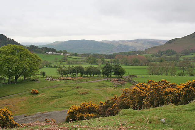
The spoil from the early workings forms a huge pale fan down the fellside west of the road, clearly visible from afar and said to be in continual slight movement; a 2018 photograph taken from the Swinside Inn shows it as screes on the flank of the fell. The later workings around Uzzicar survive as rough ground, photographed in 2013. The National Trust's record, drawing on a 2020 historic landscape survey of Derwentwater, notes some recent land slippage.
The large spoil fan below the early levels west of the road, and the rough ground of the later shaft workings beside Uzzicar.
Redevelopment
No redevelopment: the spoil and the later workings remain as rough ground on the fellside and beside Uzzicar.
Related mines
- Brandelhow Mine — John Tebay, who reopened Brandelhow from 1819, also leased Barrow in the 1830s.
- Thornthwaite Mine — The National Trust's record reads the Barrow Lode as part of one large vein of which the Thornthwaite and Yewthwaite lodes are others.
- Yewthwaite Mine — H. K. Spark and B. Plummer (Plunner) held both; when their prospecting at Barrow failed in the early 1870s they moved its miners to Yewthwaite. The two lodes are also read as parts of one large vein.
Nearby mines
- Goldscope Mine — 1.0 km E
- Brandelhow Mine — 1.4 km E
- Thornthwaite Mine — 2.6 km NE
- Yewthwaite Mine — 2.6 km S
- Force Crag Mine — 3.3 km W
Straight-line distance, within 15 km. Show on the map.
People
- David Davies · engineer, 1680–1689 — Mining engineer working throughout the Derwent Fells in the 1680s, with a particular interest in Goldscope and Barrow; his letter to the Duke of Somerset is the earliest document naming the mine.
- B. Plummer · lessee, 1870–1873 — Spelled 'B. Plunner' in the National Trust's Barrow record and 'B. Plummer' in its Yewthwaite record; took Barrow with H. K. Spark in 1870.
- H. K. Spark · lessee, 1870–1873 — Took the mine with B. Plunner in 1870, prospected and extended No. 3 level for three years, then moved the miners to Yewthwaite.
- John Tebay · lessee, 1830–1839 — via the operator record
- Henry Vercoe · proprietor, 1883–1887 — via the operator record Barrow Mining Company
What's uncertain
Points where sources disagree or the record could not be settled; both accounts are kept. All open questions in the archive.
- Barrow mine first opened in the 17th century. (disputed) 3
- Mining ceased in 1889, when the Braithwaite Mining Company went into liquidation; the plant and machinery were sold on 2 January 1896. (disputed) 1
- Barrow mine closed in 1888. (disputed) 3,5
Recorded claims
Individual factual claims, each attached to the source(s) that support it below. Where sources disagree, both are kept.
- The earliest document naming the mine is a letter of the 1680s from the mining engineer David Davies to Charles, Duke of Somerset; Davies took a particular interest in Goldscope and Barrow. 1
- The Elizabethans worked lead mines in the Derwentwater area, Barrow among them. 2
- Barrow mine first opened in the 17th century. (disputed) 3
- Between 1854 and 1857 the Keswick Mining Company took 300 tons of ore from old ground left by earlier miners, yielding 1,700 ounces of silver. 1
- Henry Vercoe's Barrow Mining Company sank a shaft from 1883; by 1886 the workings were 30 fathoms down with a 60-foot, 75-horsepower waterwheel for dressing and pumping, and the Braithwaite Mining Company later took the shaft to 42 fathoms. 1,4
- Only 210 tons of lead ore and 21 tons of blende were raised between 1886 and 1888. 1
- Mining ceased in 1889, when the Braithwaite Mining Company went into liquidation; the plant and machinery were sold on 2 January 1896. (disputed) 1
- Barrow mine closed in 1888. (disputed) 3,5
- The lode divides into two branches about 17 fathoms apart; the western Sand Vein held so much friable quartz that it could flow like sand and fill the workings within a few minutes. 1
- The spoil heaps from the early workings sweep down to the road and are said to be in continual slight movement. 1,3
Photographs & further reading
The fullest account of the mine: the Barrow Lode and its Sand Vein, and the working history from the 1680s to the sale of the plant in 1896.
View sourceA Cumbrian Amenity Trust plan showing levels 1 to 4 in section with the Uzzicar shaft.
View sourceThe mine's spoil heaps seen as screes on the fellside from the Swinside Inn.
View sourceSources
- (primary) Barrow (Uzzicar) Mine near Low Uzzicar, Derwentwater, Borrowdale (MNA118610) — National Trust Heritage Records Online
- (secondary) Lead and Zinc — Industrial History of Cumbria
- (secondary) Barrow (Lake District) — Wikipedia
- (primary) Mine plan CT212, BARROW MINE KESWICK: section of levels 1 to 4 and plan of Uzzicar shaft — BGS / Cumbrian Amenity Trust Historical Mining Society mine plans
- (observational) Towards Barrow (photograph, 2018) — Geograph Britain and Ireland
- (observational) Barrow Mine (photograph, 2013) — Geograph Britain and Ireland
- (primary) Brandelhow Barrow Dalehead Forcecrag Goldscope Plumbago Thornthwaite (BGS Mine Plans Catalogue) — British Geological Survey / The Coal Authority
- (primary) Mine plan CT184, BARROW MINE: plan showing Nos. 2 and 3 levels — BGS / Cumbrian Amenity Trust Historical Mining Society mine plans
- (primary) Plan showing position of the Thornthwaite, Barrow, Brandlehow, Force Crag and Goldscope lead mines, 1858 — BGS / Cumbria Amenity Trust Mining History Society mine plans
Record created: 18 September 2026 · Last researched: 18 September 2026