 MineArchive
Wheal Hermon
| Also known as | Wheal St Just, Hermeno, Hermon Mine, Wheal Hermann, Wheal Herman |
|---|---|
| Location | Cot Valley, between Porth Nanven and Letcha, St Just, Cornwall — 50.1166, -5.6973 (exact) |
| Commodity | Tin |
| Type | Metal |
| Worked | 1560–1915 (last production) |
| Maximum depth | At least 100 ft (the level unwatered for sampling in 1964). |
| Operators | Wheal Hermon Mining Company (1874–1881), H. F. Olds (1914–1914), Corderoy Mines Ltd (1924–?), Uroz Company Ltd (1924–1932), Penwith Mineral Explorations Ltd (1964–1976) |
Overview
Reputed to be the oldest tin mine in Cornwall marked on a map -- Hatfield's 1560 survey of the St Just district, which shows it as 'Hermeno' -- with recorded working continuing on and off into the early 19th century.
History
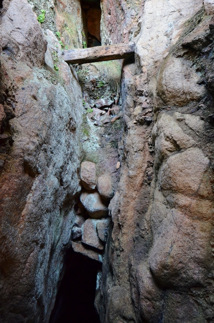
Wheal Hermon, also known as Wheal St Just, lies at the seaward end of the Cot Valley between Porth Nanven and Letcha Farm, St Just. It is reputed to be the oldest tin mine in Cornwall marked on any map: the 1560 Hatfield survey of St Just mining operations shows a working called 'Hermeno', generally identified as Wheal Hermon, and documented working is thought to have continued from around that date until sometime after 1584, when the mine was recorded again by the surveyor John Norden. Mining activity in the area very likely predates even this documentary record. An anvil stone made from a beach boulder, turned up between two shafts on the main lode, is taken as a sign of the site's antiquity, and at one spot in the adit early miners cut their initials, among them 'W.R. 1759' and 'J.P. 1759'.
Later activity is recorded in 1716, and again from 1753 to around 1770; part of the sett was reworked under the name Lower Hermon Bounds in 1787, and is next mentioned, as part of Great and Little Hermon Bounds, in 1816. After a few idle years the mine was at work again in 1822, drained by a waterwheel 32 feet across and 3 feet wide; Cornwall Calling has this working begin in 1821 as Wheal St Just, with a single shaft sunk on the Hermon lode just above high-water mark, and take the name Wheal Hermon from 1822. It was worked together with Letcha and Wheal Oak until 1835, when it was offered for sale. A reworking from 1837 to 1841 has been suggested but is not borne out by the records, and by 1857 the sett was being mapped as Letcha Mine, with Wheal Hermon occupying only its north-western corner.
The mine restarted in 1874, was suspended between 1876 and 1878, and had stopped again by 1881 after another short run; it appears in the official lists of mines of these years under the Wheal Hermon Mining Company. A company formed in 1891 to restart it bought engines, but an inspection by Captain Josiah Thomas of Dolcoath in 1892 held out little hope and nothing more was done. In 1914 H.F. Olds reopened the mine; he was killed by a fall down a shaft the same year, but production continued until the end of 1915.
Corderoy Mines Ltd acquired the mine in 1924 together with Letcha and Progo and granted an option to work it to the Uroz Company, which lapsed four years later without any production; the Consolidated Mines and Minerals Development Corporation, which had taken over Uroz, held an option until 1932. The ground was examined during the Second World War without result. In 1890, meanwhile, a separate venture, Wheal Bellan, had been formed at the western end of the Cot Valley to work the lodes of St Just United and Wheal Hermon at depth and out under the sea, but very little mining followed and that site was abandoned after the war.
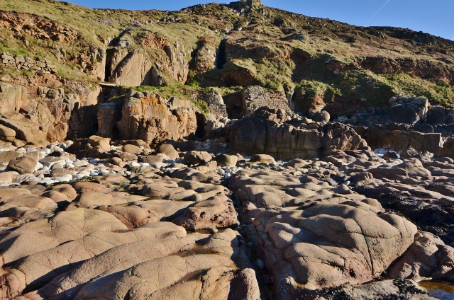
In 1964 the sett was leased from Penwith Mineral Explorations Ltd by another Mr Olds, who unwatered the mine to the 100-foot level for sampling; the company went into liquidation in 1976 without any development, and the Trevithick Society accordingly gives the mine's span as 1560 to 1976. The lodes outcrop on the foreshore and in the cliffs, and have in many places been worked open to surface. A medieval wood-and-iron drainage pump tube from the mine has been dated by York Archaeological Trust for the National Trust.
Geology
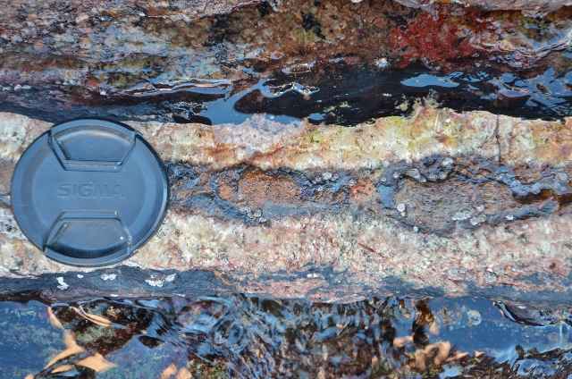
Tin lodes in granite at the seaward end of the Cot Valley, St Just: seven lodes or lode groups, most trending north-west to south-east, outcropping on the foreshore at Porth Nanven and in the cliffs, where the vein can be seen as a thin band of quartz and dark mineral in the granite. A prospecting adit in the valley floor was driven on the Riblows Lode. Cassiterite, the tin ore, and fluorite are recorded from the mine.
Workings
Seven lodes or groups of lodes, most trending north-west to south-east, were worked from the beach at Porth Nanven up the southern slopes of the Cot Valley towards Letcha Farm: chains of outcrop pits and openworks on the valley lodes, narrow slot-like gunnises with large waste dumps on the central lodes in the cliff, and small gunnises on eight minor lodes on Hermon Cliff. Hermon Shaft, on the main central lode, was refitted in the 20th century with a steam winder and a concrete headframe; adits enter from the beach and the valley floor, several of them only prospecting cross-cuts. Part of the sett was reworked as Lower Hermon Bounds from 1787, and in 1964 the mine was unwatered to the 100-foot level.
Closure
The last recorded production was in 1915, after H.F. Olds' short reopening of 1914; the options held by the Uroz Company and its successor to 1932, a wartime examination, and the 1964 unwatering for sampling all ended without a further working, and the sett company was wound up in 1976. The mine's life is notable for how far back it can be documented rather than for when it finally ended.
What remains
Described by the Cornwall Archaeological Unit's 1997 survey as one of the best-preserved early mining landscapes in West Cornwall, and part of the Cornwall and West Devon Mining Landscape World Heritage Site. Hundreds of metres of open or partly choked gunnises and outcrop workings survive on Hermon Cliff and the southern slopes of the Cot Valley, with a small number of open shafts, some hedged, fenced or grilled in 1997.
Chains of overgrown outcrop pits, openworks and cliff gunnises with their waste dumps; stone-collared shafts; adits at beach level and in the valley; the concrete headframe and engine plinths, a lined tank and the footings of a small building at Hermon Shaft, exposed in 1997; a section of massive masonry walling at the back of Nanven beach, variously read as a wheelpit for the 1822 waterwheel, the start of an engine house or a headgear plinth; and a walled enclosure that held a horse whim on the 1880 Ordnance Survey map. Few other structures survive.
Related mines
- Letcha Mine — Adjoining setts worked together until 1835; Symons's 1857 Letcha Mine took in Hermon (kept as separate records under the user's ruling of 2026-10-08).
- Wheal Bellan — Wheal Bellan was formed in 1890 at the western end of the Cot Valley to work the lodes of St Just United and Wheal Hermon at depth and out under the sea (Cornwall Calling).
Nearby mines
- Letcha Mine — 0.2 miles (0.3 km) S
- Wheal Bellan — 0.4 miles (0.6 km) N
- St Just Amalgamated Mines — 0.5 miles (0.9 km) NW
- Wheal Cunning — 0.7 miles (1.2 km) N
- Boswedden Mine — 0.8 miles (1.3 km) N
Straight-line distance, within 9 miles (15 km). Show on the map.
Recorded claims
Individual factual claims, each attached to the source(s) that support it below. Where sources disagree, both are kept.
- The 1560 Hatfield survey of St Just mining operations shows a working called 'Hermeno', generally identified as Wheal Hermon -- reputedly the oldest tin mine in Cornwall marked on any map. 1
- Later activity at Wheal Hermon is recorded in 1716, 1753-1770, and as Lower Hermon Bounds from 1787, next mentioned in 1816. 2
- Cornwall Calling has the mine started in 1821 as Wheal St Just, with a single shaft sunk on the Hermon lode just above high-water mark, and worked as Wheal Hermon from 1822; the lodes outcrop on the foreshore and in the cliffs, where in many places they have been worked open to surface. The Trevithick Society records the mine as Wheal Hermon 1560-1976, and it was prospected several times in the 20th century, most recently in the late 1960s and early 1970s. In 1890 Wheal Bellan was formed at the western end of the Cot Valley to work the lodes of St Just United and Wheal Hermon at depth and out to sea, but very little mining took place and the site was abandoned after the Second World War. York Archaeological Trust dated a medieval wood-and-iron drainage pump tube from the mine for the National Trust. 3
- The British Geological Survey's catalogue holds a scanned vertical longitudinal section of Wheal Hermon, section O-O (MP24443). 4
- The National Trust Heritage Record places the mine at grid reference SW 3579 3060, at the seaward end of the Cot Valley between Porth Nanven and Letcha. 2
- The mine was at work again in 1822, drained by a 32-foot by 3-foot waterwheel, and was worked with Letcha and Wheal Oak until it was offered for sale in 1835. 2
- The mine restarted in 1874, was suspended between 1876 and 1878, and had stopped again by 1881; the official lists of mines of these years carry it under the Wheal Hermon Mining Company. 2,5
- A company formed in 1891 to restart the mine purchased engines, but an inspection by Captain Josiah Thomas of Dolcoath in 1892 gave little encouragement and nothing was done. 2
- H.F. Olds reopened the mine in 1914 and was killed by a fall down a shaft the same year; production continued until the end of 1915. 2
- Corderoy Mines Ltd acquired the mine with Letcha and Progo in 1924 and granted the Uroz Company an option to work it, which ended after four years without production; the Consolidated Mines and Minerals Development Corporation, Uroz's successor, held an option until 1932. 2
- In 1964 the sett was leased from Penwith Mineral Explorations Ltd by a Mr Olds, who unwatered the mine to the 100-foot level for sampling; the company went into liquidation in 1976 without development. 2
- Seven lodes or groups of lodes, most trending north-west to south-east, were worked between Porth Nanven and Letcha Farm, the most productive outcropping on a line from just south of Pen Nanven to Letcha Farm. 2
- Hermon Shaft, at SW 3580 3061, carries mass-concrete headframe plinths and the plinths of a small steam engine from its 20th-century refitting; the 1880 Ordnance Survey marked horse whims on the main lode, one of them destroyed by that refitting. 2
- Early miners inscribed initials in the adit, including 'W.R. 1759' and 'J.P. 1759', and an anvil stone made from a beach boulder was found between two shafts on the main lode. 2
- The Cornwall Archaeological Unit's 1997 survey called Hermon one of the best-preserved early mining landscapes in West Cornwall; it lies within the Cornwall and West Devon Mining Landscape World Heritage Site. 2
- Cassiterite and fluorite are recorded from the mine. 1
Photographs & further reading
The locality page, with the position, photographs of the stopes on the Hermon lode and the minerals recorded from the mine.
View sourceThe 1997 Cornwall Archaeological Unit assessment of the mine, lode by lode, with its documented history from 1560 to 1976 and the grid reference of the site.
View sourceZoomable scan of the Geevor Tin Mines Ltd longitudinal section through Wheal Hermon (section O-O, 1:2500), showing the shafts, the Hermon lode and the ground beneath the shore.
View sourceSources
- (secondary) Wheal Hermon (Wheal St Just), Cot Valley, St Just — Mindat
- (primary) Wheal Hermon Tin Mine, Letcha and the Cot Valley, St Just — National Trust Heritage Records
- (secondary) Wheal Hermon Mine, Cornwall (Cornwall Calling) — Cornwall Calling
- (primary) Mine plan: vertical longitudinal section, Wheal Hermon, section O-O (MP24443) (BGS Mine Plans catalogue) — British Geological Survey
- (secondary) Hermon (Whl) — NMRS mine directory entry — Northern Mine Research Society
Record created: 1 September 2026 · Last researched: 30 September 2026