 MineArchive
Warrix Colliery
| Also known as | Warrix Pit, Warrix No. 2 |
|---|---|
| Location | Warrix, Irvine, North Ayrshire — 55.6073, -4.6519 (approximate) |
| Commodities | Coal, Fireclay |
| Type | Coal |
| Worked | 1894–November 1950 |
| Maximum depth | Unknown. |
| Operators | Bourtreehill Coal Co., Ltd. (1894–1947), National Coal Board (1947–1950) |
Overview
The Bourtreehill Coal Company's coal and fireclay pit at Warrix, near Irvine, sunk in 1894 during a strike and worked until November 1950, with a fireclay works beside it.
History
Warrix Colliery was sunk at Warrix, near Irvine, in 1894 by the Bourtreehill Coal and Fire Clay Company of Dreghorn. The sinkers reached the coal in August that year, during a miners' strike: men were set to take coal out at the bottom of the shaft, it was carted away and sold at fifteen shillings a ton, and pickets thirty-five strong went out on two mornings to stop the work, without success. By December a good field of fireclay had been found beside the new pit, and the company built the Warrix Fireclay Works to use it. The sinking was held up by a strong post of whinstone, but in 1899 the company struck the Ell coal, the Ladyha' seam having been passed through earlier, with clay beneath it to supply the works for years.
Warrix raised household and manufacturing coal with fireclay. It employed 71 people in 1900 but only 33 in 1910, working the Ladyha' and Major seams. No. 1 Pit had been given up by 1915, and No. 2, in the McNaught and Tourha' seams, employed 128 in 1920. The Kenneth family, coalmasters at Bourtreehill and Shewalton, had the Warrix pits and fireclay works. At nationalisation in 1947 Warrix employed 109 people and raised 38,000 tons. It closed in November 1950, and the abandonment plans of No. 2 are dated December that year. The site of the pits and fireclay works is now the Warrix Interchange.
Geology
Ayrshire coalfield: the Ladyha', Ell, Major, McNaught and Tourha' seams, with fireclay under the coal.
Workings
Nos. 1 and 2 Pits, sunk from 1894; No. 1 given up by 1915; a fireclay works alongside, built from about 1894.
Closure
Closed by the National Coal Board in November 1950; the No. 2 Pit plans of the McNaught and Tourha' seams are dated December 1950. Earlier McNaught and Tourha' workings were abandoned in 1925.
What remains
The site is occupied by the Warrix Interchange.
Redevelopment
The Warrix Interchange occupies the site of the pits and fireclay works.
Nearby mines
- Bartonholm Colliery — 2.3 miles (3.7 km) NW
- Fergushill Colliery — 3.2 miles (5.2 km) N
- Doura Colliery — 4.4 miles (7.0 km) N
- Annandale Colliery — 4.7 miles (7.6 km) E, East Ayrshire
- Auchenharvie Colliery — 5.0 miles (8.0 km) W
Straight-line distance, within 9 miles (15 km). Show on the map.
Recorded claims
Individual factual claims, each attached to the source(s) that support it below. Where sources disagree, both are kept.
- Warrix was sunk by the Bourtreehill Coal and Fire Clay Company, whose sinkers reached the coal in August 1894 during a strike. 1
- In 1899 the company struck the Ell coal at Warrix after the sinking was held up by whinstone. 1
- Warrix employed 71 people in 1900, 33 in 1910, 128 in 1920 and 109 in 1947, when it raised 38,000 tons. 2,3
- Warrix closed in November 1950; its No. 2 Pit plans are dated December 1950. 4,5
- The site of the Warrix pits and fireclay works is now the Warrix Interchange. 6
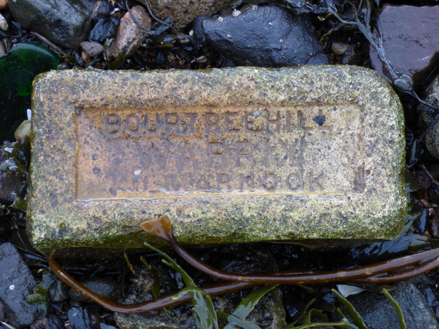
- Bricks stamped 'Bourtreehill Warrix Kilmarnock' survive far from the works. 7
Photographs & further reading
Owners, employment, seams and output of the colliery.
View sourceNewspaper reports of the sinking of the pit and the building of its fireclay works.
View sourceSources
- (secondary) Warrix Fire Clay Works, Irvine, North Ayrshire — Scottish Brick History
- (primary) Warrix Colliery — Durham Mining Museum
- (primary) Bourtreehill Coal Co., Ltd. — Durham Mining Museum
- (secondary) NCB Collieries - Scotland (Northern Mine Research Society) — Northern Mine Research Society
- (primary) BGS mine plan: Warrix No 2, McNaught and Tourha, abandoned December 1950 — BGS / Mining Remediation Authority mine plans
- (secondary) Dreghorn, Ayrshire: Collieries — Dreghorn, Ayrshire (local history site)
- (observational) Old brick at Garvel Point (Geograph 6815139) — Geograph
Record created: 4 October 2026 · Last researched: 4 October 2026